Nipissing, Ontario
Nipissing is an incorporated (political) township in Parry Sound District in Central Ontario, Canada.[1][3] It is on Lake Nipissing and is part of the Almaguin Highlands region. Nipissing was surveyed between 1874 and 1881, and was incorporated in 1888. Among the first settlers in the area were the Chapman and Beatty families. Nipissing Township annexed Gurd Township in 1970. The township also contains a community named Nipissing, which is located on the South River near Chapman's Landing, on the South Bay of Lake Nipissing. The township administrative offices are located in Nipissing.
Nipissing | |
|---|---|
| Township of Nipissing | |
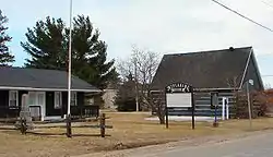 Nipissing Township Museum | |
| Motto(s): Life the Way it Should Be. | |
 Nipissing Location of Nipissing Township in Ontario | |
| Coordinates: 46°03′N 79°33′W[1] | |
| Country | Canada |
| Province | Ontario |
| District | Parry Sound |
| Settled | 1862 |
| Incorporated | 1888 |
| Government | |
| • Type | Township |
| • Mayor | Tom Piper |
| • Federal riding | Nipissing—Timiskaming |
| • Prov. riding | Nipissing |
| Area | |
| • Land | 393.80 km2 (152.05 sq mi) |
| Population (2016)[2] | |
| • Total | 1,707 |
| • Density | 4.3/km2 (11/sq mi) |
| Time zone | UTC-5 (EST) |
| • Summer (DST) | UTC-4 (EDT) |
| Postal Code | P0H |
| Area code(s) | 705 |
| Website | nipissingtownship |
The township includes the communities of Alsace, Christian Valley, Commanda, Hotham, Nipissing and Wade's Landing.
History
The founder of Nipissing, John Beattie (John Beatty) arrived by canoe from Eganville in 1862. He was looking for land suitable for settlement. To lay claim to the property, he made brush piles, and was granted free land by the Government of Ontario. Around 1869 James Chapman and his wife, Phoebe Edwards, built their first house and barn at the top of the chutes that later took their name. The family farmed the area and James carried the mail by canoe, dog team and later horse on a route stretching 200 miles (320 km) between the villages of Magnetawan and Mattawa. The Chapman Valley and Chapman Township near Magnetawan are named after the family. James and Phoebe are among the pioneers buried in the Nipissing village cemetery. The Chapman family donated the land to the municipal government, and the landing became a municipal boat launch, public dock and swimming hole for village children.
Originally supplies were brought into Nipissing from Pembroke by canoe over the Champlain Trail, as well as the South River. Nipissing village became the main route for shipping supplies. Around 1875 a colonization road was completed which connected tiny Nipissing village to Rosseau near Parry Sound in the south and this created road travel and another route for shipment of supplies. An Ontario Historical Plaque was erected at the Nipissing Township Museum by the province to commemorate the Rosseau-Nipissing Road's role in Ontario's heritage.[4] However, in 1886 the Northern and Pacific Junction Railway connected Gravenhurst to Callander cutting out Nipissing village from its main route and the life of the village as a key port began to fade.
Etymology
Named in 1879 after the lake, on whose south shore it is located. The community of Nipissing in the township, 25 km south of North Bay, was called Nipissingan in 1870, but its name was changed to Nipissing in 1881.[5]
Transportation
The township is served in its northern part by Ontario Highway 534 and Ontario Highway 654, which connect east to Ontario Highway 11 at the communities of Powassan and Callander respectively; Ontario Highway 534 also connects west to Restoule Provincial Park, and via Ontario Highway 524 to Ontario Highway 522. The township is served across its southern part by Ontario Highway 522, which connects east to Highway 11 at Trout Creek and west to Ontario Highway 69 at the community of Cranberry.
Demographics
| Canada census – Nipissing, Ontario community profile | |||
|---|---|---|---|
| 2016 | 2011 | ||
| Population: | 1,707 (+0.2% from 2011) | 1,704 (+3.8% from 2006) | |
| Land area: | 393.8 km2 (152.0 sq mi) | 393.6 km2 (152.0 sq mi) | |
| Population density: | 4.3/km2 (11/sq mi) | 4.3/km2 (11/sq mi) | |
| Median age: | 52.0 (M: 52.7, F: 51.2) | 49.1 (M: 49.4, F: 49.0) | |
| Total private dwellings: | 1,051 | 993 | |
| Median household income: | $70,229 | ||
| References: 2016[6] 2011[7] earlier[8] | |||
See also
References
- "Nipissing". Geographical Names Data Base. Natural Resources Canada. Retrieved 2013-03-04.
- "Census Profile, 2016 Census: Nipissing, Township". Statistics Canada. Retrieved June 27, 2019.
- "Pringle" (PDF). Geology Ontario - Historic Claim Maps. Ontario Ministry of Northern Development, Mines and Forestry. Retrieved 2013-03-04.
- "The Rosseau-Nipissing Road". OntarioPlaques.com. Alan L. Brown. Retrieved June 27, 2019.
- Rayburn, Alan (1997). Place Names of Ontario. Toronto: University of Toronto Press. p. 243. ISBN 0-8020-7207-0. OCLC 36342881.
- "2016 Community Profiles". 2016 Canadian Census. Statistics Canada. February 21, 2017. Retrieved 2019-06-27.
- "2011 Community Profiles". 2011 Canadian Census. Statistics Canada. July 5, 2013. Retrieved 2019-06-27.
- "2001 Community Profiles". 2001 Canadian Census. Statistics Canada. February 17, 2012.
Other map sources:
- Map 8 (PDF) (Map). 1 : 700,000. Official road map of Ontario. Ministry of Transportation of Ontario. 2012-01-01. Retrieved 2013-03-04.
- Restructured municipalities - Ontario map #4 (Map). Restructuring Maps of Ontario. Ontario Ministry of Municipal Affairs and Housing. 2006. Retrieved 2013-03-04.
- Official Plan - Schedule 'A' (PDF) (Map). 1 : 40,000. Township of Nipissing. 2005-10-28. Retrieved 2013-03-04.
External links
Places adjacent to Nipissing, Ontario | |
|---|---|
| Towns | 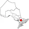 | |
|---|---|---|
| Townships | ||
| Villages | ||
| First Nations | ||
| Indian reserves | ||
| Local services boards | ||
| Unorganized areas | ||
| ||