Attock Tehsil
Attock Tehsil (in Punjabi and Urdu: تحصیل اٹک) is one of the six tehsils of Attock District in the Punjab Province of Pakistan.[2] The Indus River bounds it on the north-west, dividing it from the Khyber Pakhtunkhwa, while the Haro River flows through from east to west.[3]
Attock Tehsil | |
|---|---|
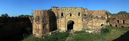 View of Attock Fort | |
 Attock Tehsil | |
| Coordinates: 33°46′0″N 72°22′0″E | |
| Country | Pakistan |
| Province | Punjab |
| District | Attock |
| Population (2017) | |
| • Total | 434,705[1] |
| Time zone | UTC+5 (PST) |
The north-west corner is occupied by the fertile Chach Valley. South of this lies a dry sandy plain, beyond which rises the Kala Chitta Range. The eastern half consists of the tract known as the Nala, which includes, along with a number of low hills and much broken country, a considerable area of fairly good level land, portions of which are irrigated from wells and by cuts from the Haro and other smaller streams.[4]
History
According to the Imperial Gazetteer of India:
"The population in 1901 was 150,550 compared with 141,063 in 1891. It contains the towns of Attock (population, 2,822), Hazro (9,799), the cantonment of Campbellpur (5,036) and 191 villages. The land revenue and cesses amounted in 1903-4 to 9 lakhs. Hasan Abdal, is a place of historical interest.[4]
References
- "POPULATION AND HOUSEHOLD DETAIL FROM BLOCK TO DISTRICT LEVEL: PUNJAB (ATTOCK DISTRICT)" (PDF). Pakistan Bureau of Statistics, Government of Pakistan. Retrieved Jul 14, 2020.
- POPULATION CENSUS ORGANIZATION, Government of Pakistan Archived December 30, 2010, at the Wayback Machine
- "Attock (Tehsil, Pakistan) - Population Statistics, Charts, Map and Location". www.citypopulation.de. Retrieved 2018-09-05.
- Attock Tahsil - Imperial Gazetteer of India, v. 6, p. 138