Augerville-la-Rivière
Augerville-la-Rivière is a commune in the Loiret department in north-central France. It is the site of the Château d'Augerville.
Augerville-la-Rivière | |
|---|---|
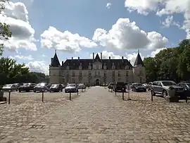 Château d'Augerville, now a hotel | |
 Coat of arms | |
Location of Augerville-la-Rivière 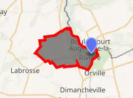
| |
 Augerville-la-Rivière  Augerville-la-Rivière | |
| Coordinates: 48°15′10″N 2°26′14″E | |
| Country | France |
| Region | Centre-Val de Loire |
| Department | Loiret |
| Arrondissement | Pithiviers |
| Canton | Malesherbes |
| Intercommunality | CC Pithiverais-Gâtinais |
| Government | |
| • Mayor (2014-2020) | Olivier Citron |
| Area 1 | 4.03 km2 (1.56 sq mi) |
| Population (2017-01-01)[1] | 232 |
| • Density | 58/km2 (150/sq mi) |
| Time zone | UTC+01:00 (CET) |
| • Summer (DST) | UTC+02:00 (CEST) |
| INSEE/Postal code | 45013 /45330 |
| Elevation | 72–120 m (236–394 ft) |
| 1 French Land Register data, which excludes lakes, ponds, glaciers > 1 km2 (0.386 sq mi or 247 acres) and river estuaries. | |
Population
| Year | Pop. | ±% |
|---|---|---|
| 1793 | 280 | — |
| 1800 | 269 | −3.9% |
| 1806 | 276 | +2.6% |
| 1821 | 284 | +2.9% |
| 1831 | 301 | +6.0% |
| 1836 | 322 | +7.0% |
| 1841 | 305 | −5.3% |
| 1846 | 291 | −4.6% |
| 1851 | 304 | +4.5% |
| 1856 | 304 | +0.0% |
| 1861 | 306 | +0.7% |
| 1866 | 300 | −2.0% |
| 1872 | 264 | −12.0% |
| 1876 | 264 | +0.0% |
| 1881 | 267 | +1.1% |
| 1886 | 224 | −16.1% |
| 1891 | 238 | +6.2% |
| 1896 | 222 | −6.7% |
| 1901 | 232 | +4.5% |
| 1906 | 212 | −8.6% |
| 1911 | 234 | +10.4% |
| 1921 | 207 | −11.5% |
| 1926 | 183 | −11.6% |
| 1931 | 158 | −13.7% |
| 1936 | 153 | −3.2% |
| 1946 | 149 | −2.6% |
| 1954 | 134 | −10.1% |
| 1962 | 177 | +32.1% |
| 1968 | 165 | −6.8% |
| 1975 | 165 | +0.0% |
| 1982 | 164 | −0.6% |
| 1990 | 170 | +3.7% |
| 1999 | 193 | +13.5% |
| 2006 | 228 | +18.1% |
| 2009 | 233 | +2.2% |
| 2015 | 234 | +0.4% |
See also
References
- "Populations légales 2017". INSEE. Retrieved 6 January 2020.
| Wikimedia Commons has media related to Augerville-la-Rivière. |
| Authority control |
|---|
This article is issued from Wikipedia. The text is licensed under Creative Commons - Attribution - Sharealike. Additional terms may apply for the media files.