Baie-Johan-Beetz, Quebec
Baie-Johan-Beetz is a municipality and village in the Côte-Nord region of the province of Quebec in Canada, located some 60 kilometres (37 mi) east of Havre-Saint-Pierre. It has the lowest population of all incorporated places in the Côte-Nord region.
Baie-Johan-Beetz | |
|---|---|
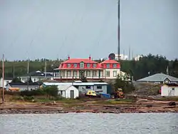 Le château | |
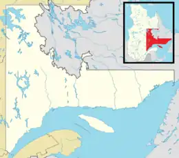 Baie-Johan-Beetz Location in Côte-Nord region of Quebec. | |
| Coordinates: 50°17′N 62°48′W[1] | |
| Country | |
| Province | |
| Region | Côte-Nord |
| RCM | Minganie |
| Constituted | 1 January 1966 |
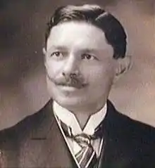
| Named for | Johan Beetz |
| Government | |
| • Mayor | Martin Côté |
| • Federal riding | Manicouagan |
| • Prov. riding | Duplessis |
| Area | |
| • Total | 525.40 km2 (202.86 sq mi) |
| • Land | 360.28 km2 (139.10 sq mi) |
| Elevation | 10 m (30 ft) |
| Population (2011)[4] | |
| • Total | 81 |
| • Density | 0.2/km2 (0.5/sq mi) |
| • Pop 2006-2011 | |
| • Dwellings | 46 |
| Time zone | UTC-5 (Within the AST legislated time zone boundary but observes EST[5]) |
| • Summer (DST) | UTC-4 (EDT) |
| Postal code(s) | G0G 1B0 |
| Area code(s) | 418 and 581 |
| Highways | |
| Website | www |
History
Joseph Tanguay, originally from Berthier, settled at the Little Watshishou River in 1854. Tanguay and his sons fished mostly for salmon on the Piashti, Corneille, Petite Watshishou, Watshishou and Quetachou rivers. In 1862 Tanguay moved to Baie Piashti.[6] Other early settlers came from the Magdalen Islands. The place was originally identified as "Piastre Bay", from the Innu expression piashite-pets, meaning "there where the water passes over/on top", or possibly originating from the word piashtibé, meaning "dry bay" or "where the water rises", which is a reference to the local bay that during low tide runs dry.[1]
The bay's name was spelled in a variety of ways, including Piashti Bay, Pillage Bay, Baie-de-Pillage, Piastibe, Piashte Bay, and Piestebé. Perhaps for this reason, its residents expressed a desire to change the village's name to Baie-Johan-Beetz in 1910. Johan Beetz (1874-1949) was a Belgian naturalist, who lived in the Bay from 1897 to 1922. He had moved there to breed fur animals, particularly foxes, and built a luxurious manor that residents today call le château (the castle). The bay was renamed in 1914, but the name was not officially adopted until 1965 when the place was incorporated.[1]
In 1996, Highway 138 was extended to Baie-Johan-Beetz, linking it to the municipality of Havre-Saint-Pierre and thereby breaking its isolation.[1]
Demographics
Population
| Canada census – Baie-Johan-Beetz, Quebec community profile | |||
|---|---|---|---|
| 2011 | 2006 | ||
| Population: | 81 (-14.7% from 2006) | 95 (+6.7% from 2001) | |
| Land area: | 360.28 km2 (139.10 sq mi) | 360.28 km2 (139.10 sq mi) | |
| Population density: | 0.2/km2 (0.52/sq mi) | 0.3/km2 (0.78/sq mi) | |
| Median age: | 53.8 (M: 49.5, F: 55.0) | 51.8 (M: 49.5, F: 53.0) | |
| Total private dwellings: | 46 | 49 | |
| Median household income: | $.N/A | $.N/A | |
| Notes: Income data for this area has been suppressed for data quality or confidentiality reasons. – References: 2011[3] 2006[7] earlier[8] | |||
|
|
|
Language
| Canada Census Mother Tongue - Baie-Johan-Beetz, Quebec[9] | ||||||||||||||||||
|---|---|---|---|---|---|---|---|---|---|---|---|---|---|---|---|---|---|---|
| Census | Total | French |
English |
French & English |
Other | |||||||||||||
| Year | Responses | Count | Trend | Pop % | Count | Trend | Pop % | Count | Trend | Pop % | Count | Trend | Pop % | |||||
2011 |
80 |
80 | 100.00% | 0 | 0.00% | 0 | 0.00% | 0 | 0.00% | |||||||||
2006 |
90 |
90 | 100.00% | 0 | 0.00% | 0 | 0.00% | 0 | 0.00% | |||||||||
2001 |
85 |
85 | 100.00% | 0 | 0.00% | 0 | 0.00% | 0 | 0.00% | |||||||||
1996 |
80 |
80 | n/a | 100.00% | 0 | n/a | 0.00% | 0 | n/a | 0.00% | 0 | n/a | 0.00% | |||||
Climate
| Climate data for Baie-Johan-Beetz | |||||||||||||
|---|---|---|---|---|---|---|---|---|---|---|---|---|---|
| Month | Jan | Feb | Mar | Apr | May | Jun | Jul | Aug | Sep | Oct | Nov | Dec | Year |
| Record high °C (°F) | 8.9 (48.0) |
6.5 (43.7) |
11 (52) |
16.5 (61.7) |
32 (90) |
29 (84) |
28.5 (83.3) |
29 (84) |
28.3 (82.9) |
20.6 (69.1) |
13.3 (55.9) |
8.3 (46.9) |
32 (90) |
| Average high °C (°F) | −8.3 (17.1) |
−7.2 (19.0) |
−1.5 (29.3) |
4 (39) |
10.3 (50.5) |
15.7 (60.3) |
19.3 (66.7) |
18.8 (65.8) |
14 (57) |
7.8 (46.0) |
1.7 (35.1) |
−5.1 (22.8) |
5.8 (42.4) |
| Daily mean °C (°F) | −13.7 (7.3) |
−12.8 (9.0) |
−6.6 (20.1) |
0.2 (32.4) |
6 (43) |
11.2 (52.2) |
14.9 (58.8) |
14.2 (57.6) |
9.7 (49.5) |
4.2 (39.6) |
−1.9 (28.6) |
−9.7 (14.5) |
−1.3 (29.7) |
| Average low °C (°F) | −19.1 (−2.4) |
−18.4 (−1.1) |
−11.7 (10.9) |
−3.7 (25.3) |
1.6 (34.9) |
6.6 (43.9) |
10.4 (50.7) |
9.7 (49.5) |
5.3 (41.5) |
0.6 (33.1) |
−5.4 (22.3) |
−14.2 (6.4) |
−3.2 (26.2) |
| Record low °C (°F) | −37.8 (−36.0) |
−38 (−36) |
−35 (−31) |
−23.5 (−10.3) |
−11.1 (12.0) |
−2.5 (27.5) |
2.8 (37.0) |
−0.6 (30.9) |
−5.6 (21.9) |
−12.2 (10.0) |
−21.5 (−6.7) |
−33.9 (−29.0) |
−38 (−36) |
| Average precipitation mm (inches) | 72.4 (2.85) |
40.4 (1.59) |
60.5 (2.38) |
56.8 (2.24) |
90.8 (3.57) |
99.4 (3.91) |
101.4 (3.99) |
95.3 (3.75) |
103.9 (4.09) |
105.7 (4.16) |
89.7 (3.53) |
73.3 (2.89) |
989.6 (38.96) |
| Source: Environment Canada[10] | |||||||||||||

Transports
The city is served by the Baie-Johan-Beetz Seaplane Base (SPB) (IATA: YBJ).
See also
References
- "Baie-Johan-Beetz (Municipalité)" (in French). Commission de toponymie du Québec. Archived from the original on 23 May 2012. Retrieved 9 September 2010.
- Ministère des Affaires municipales, des Régions et de l'Occupation du territoire - Répertoire des municipalités: Baie-Johan-Beetz Archived 28 July 2011 at the Wayback Machine
- "2011 Community Profiles". 2011 Canadian Census. Statistics Canada. 5 July 2013. Retrieved 16 February 2014.
- "Baie-Johan-Beetz Census Profile". Statistics Canada, 2011 Census of Population. 8 February 2012. Retrieved 27 May 2012.
- National Research Council Canada - Time Zones & Daylight Saving Time Archived 17 March 2010 at the Wayback Machine
- Dumont 1986, pp. 44–45.
- "2006 Community Profiles". 2006 Canadian Census. Statistics Canada. 30 March 2011. Retrieved 16 February 2014.
- "2001 Community Profiles". 2001 Canadian Census. Statistics Canada. 17 February 2012.
- Statistics Canada: 1996, 2001, 2006, 2011 census
- Environment Canada Canadian Climate Normals 1971–2000, accessed 14 July 2010
| Wikimedia Commons has media related to Baie-Johan-Beetz. |
Sources
- Dumont, Jean (June 1986), Prolongement de la route 138 entre Baie Johan-Beetz et la Rivière Pashashibou (PDF) (in French), retrieved 24 September 2019
Adjacent Municipal Subdivisions | |
|---|---|
| Administrative units |
| ||||
|---|---|---|---|---|---|
| Protected areas | |||||
| Major river basins | |||||
| Significant lakes | |||||
| Transport infrastructure | |||||
| |||||