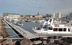
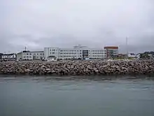
Havre-Saint-Pierre
Havre-Saint-Pierre is a town on Pointe-aux-Esquimaux, which is on the Quebec north shore (Côte-Nord) of the Saint Lawrence River in Canada]. Located along Route 138 some 200 kilometres (120 mi) east of Sept-Îles, it is the largest town and seat of the Minganie RCM, and home to many government, municipal, and regional services.
Havre-Saint-Pierre | |
|---|---|
 | |
| Motto(s): Terre digne de richesses | |
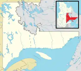 Havre-Saint-Pierre Location in Côte-Nord region of Quebec. | |
| Coordinates: 50°14′N 63°36′W[1] | |
| Country | Canada |
| Province | Quebec |
| Region | Côte-Nord |
| RCM | Minganie |
| Settled | 1857 |
| Constituted | January 1, 1873 |
| Government | |
| • Mayor | Berchmans Boudreau |
| • Federal riding | Manicouagan |
| • Prov. riding | Duplessis |
| Area | |
| • Total | 3,896.30 km2 (1,504.37 sq mi) |
| • Land | 2,817.92 km2 (1,088.00 sq mi) |
| Population (2016)[3] | |
| • Total | 3,460 |
| • Density | 1.2/km2 (3/sq mi) |
| • Pop 2011-2016 | |
| • Dwellings | 1,641 |
| Time zone | UTC−05:00 (EST) |
| • Summer (DST) | UTC−04:00 (EDT) |
| Postal code(s) | G0G 1P0 |
| Area code(s) | 418 and 581 |
| Highways | |
| Website | www |
Historically, the town's first inhabitants came from the Magdalen Islands in the nineteenth century. As a result, the people of the town speak a dialect much more closely related to Acadian French than to Quebec French.
Other important geological features near the town include the Romaine River to the north and west, les Chutes Manitou, on the Manitou River to the west, l'Ile du Havre, less than a kilometre offshore from the town, and Anticosti Island, which on clear days can be seen to the south of the town.
History
In 1857, a group of Acadian families from the Magdalen Islands, who had been deported from Savannah (Georgia, USA), settled on Eskimo Point (Pointe aux Esquimaux). The first mass was held on June 29, 1857, day of the feast of Saint Peter. In 1872, the Parish of Saint-Pierre-de-la-Pointe-aux-Esquimaux was officially established, the same year its post office opened under the name Esquimaux Point.[1]
In 1873, the place was incorporated as a municipality. In 1924, the post office changed its name to Havre-Saint-Pierre, followed by the town in 1927, in order to focus on the harbor, which characterizes the area, while retaining the original parish name. It remained the largest town on the North Shore until 1936 when it was overtaken by Baie-Comeau.[1]
Demographics
Population
| Canada census – Havre-Saint-Pierre community profile | |||
|---|---|---|---|
| 2016 | 2011 | 2006 | |
| Population: | 3,460 (+1.2% from 2011) | 3,418 (+8.5% from 2006) | 3,150 (-4.3% from 2001) |
| Land area: | 2,817.92 km2 (1,088.00 sq mi) | 2,821.65 km2 (1,089.45 sq mi) | 2,821.65 km2 (1,089.45 sq mi) |
| Population density: | 1.2/km2 (3.1/sq mi) | 1.2/km2 (3.1/sq mi) | 1.1/km2 (2.8/sq mi) |
| Median age: | 43.9 (M: 43.1, F: 45.3) | 44.2 (M: 43.5, F: 44.5) | 42.7 (M: 41.5, F: 44.0) |
| Total private dwellings: | 1,641 | 1,484 | 1,376 |
| Median household income: | $84,992 | $.N/A | $64,197 |
| Notes: 2011 income data for this area has been suppressed for data quality or confidentiality reasons. – References: 2016[3] 2011[4] 2006[5] earlier[6] | |||
|
|
|
Language
| Canada Census Mother Tongue - Havre-Saint-Pierre, Quebec[7] | ||||||||||||||||||
|---|---|---|---|---|---|---|---|---|---|---|---|---|---|---|---|---|---|---|
| Census | Total | French |
English |
French & English |
Other | |||||||||||||
| Year | Responses | Count | Trend | Pop % | Count | Trend | Pop % | Count | Trend | Pop % | Count | Trend | Pop % | |||||
2011 |
3,315 |
3,270 | 98.64% | 25 | 0.75% | 15 | 0.45% | 5 | 0.15% | |||||||||
2006 |
3,065 |
3,015 | 98.37% | 15 | 0.49% | 0 | 0.00% | 35 | 1.14% | |||||||||
2001 |
3,210 |
3,170 | 98.75% | 30 | 0.93% | 10 | 0.31% | 0 | 0.00% | |||||||||
1996 |
3,375 |
3,340 | n/a | 98.96% | 25 | n/a | 0.74% | 10 | n/a | 0.30% | 0 | n/a | 0.00% | |||||
Economy
The city hospital is the major employer in the region. Havre-Saint-Pierre is also located near Canada's only titanium mine, for which the town serves as a port. Since 1948, the Quebec Iron and Titanium Company mines deposits of ilmenite, a mineral composed of iron and titanium, at a site some 40 kilometres (25 mi) north.[1] The Chemin de fer de la Rivière Romaine brings it by rail cars to Havre-Saint-Pierre.
Tourism contributes significantly to the local economy due to the town's position near the Mingan Archipelago National Park Reserve, a park encompassing a large number of islands in Mingan Archipelago of the Gulf of Saint Lawrence. It is noted for the unique variety of flora and fauna to be found there, such as puffins and the rare Mingan Thistle, and for the unique geological features on many of the islands, which are referred to as "monoliths".
The town is also noted for the excellent fishing, being made up largely of snow crab, scallops, and lobster, with excellent salmon and trout to be found in the numerous rivers and lakes.
Climate
In spite of its maritime position just above the 50th parallel, Havre-Saint-Pierre has a relatively harsh subarctic climate,[8] with cold winters and cool summers, although the fourth-warmest month of September is relatively close to the 10 °C (50 °F) isotherm to be cold humid continental.[9] The high precipitation brings a lot of snowfall in winter.
| Climate data for Havre-Saint-Pierre | |||||||||||||
|---|---|---|---|---|---|---|---|---|---|---|---|---|---|
| Month | Jan | Feb | Mar | Apr | May | Jun | Jul | Aug | Sep | Oct | Nov | Dec | Year |
| Average high °C (°F) | −9.9 (14.2) |
−8.3 (17.1) |
−2.4 (27.7) |
3.9 (39.0) |
10.8 (51.4) |
16.0 (60.8) |
19.6 (67.3) |
19.2 (66.6) |
14.0 (57.2) |
7.5 (45.5) |
0.7 (33.3) |
−6.4 (20.5) |
5.4 (41.7) |
| Daily mean °C (°F) | −15.5 (4.1) |
−14.2 (6.4) |
−8.0 (17.6) |
−0.3 (31.5) |
5.9 (42.6) |
11.0 (51.8) |
14.6 (58.3) |
14.4 (57.9) |
9.5 (49.1) |
3.6 (38.5) |
−3.3 (26.1) |
−11.4 (11.5) |
0.5 (32.9) |
| Average low °C (°F) | −21.1 (−6.0) |
−20.1 (−4.2) |
−13.6 (7.5) |
−4.5 (23.9) |
0.9 (33.6) |
5.9 (42.6) |
9.5 (49.1) |
9.5 (49.1) |
4.9 (40.8) |
−0.3 (31.5) |
−7.2 (19.0) |
−16.4 (2.5) |
−4.4 (24.1) |
| Average precipitation mm (inches) | 77.4 (3.05) |
46 (1.8) |
60.5 (2.38) |
63.7 (2.51) |
87 (3.4) |
105.7 (4.16) |
99.9 (3.93) |
108.6 (4.28) |
96.6 (3.80) |
118.6 (4.67) |
99.4 (3.91) |
94.7 (3.73) |
1,058 (41.7) |
| Source: Weatherbase[9] | |||||||||||||
Notable residents
- Roland-Benoît Jomphe, CM CQ, poet
- Jean-François Jomphe, NHL ice hockey player, was born in Havre-Saint-Pierre
See also
References
- "Havre-Saint-Pierre (Municipalité)" (in French). Commission de toponymie du Québec. Retrieved 2010-09-09.
- Ministère des Affaires municipales, des Régions et de l'Occupation du territoire - Répertoire des municipalités: Havre-Saint-Pierre Archived 2012-05-01 at the Wayback Machine
- "2016 Community Profiles". 2016 Canadian Census. Statistics Canada. February 21, 2017. Retrieved 2018-12-21.
- "2011 Community Profiles". 2011 Canadian Census. Statistics Canada. July 5, 2013. Retrieved 2014-02-16.
- "2006 Community Profiles". 2006 Canadian Census. Statistics Canada. March 30, 2011. Retrieved 2014-02-16.
- "2001 Community Profiles". 2001 Canadian Census. Statistics Canada. February 17, 2012.
- Statistics Canada: 1996, 2001, 2006, 2011 census
- "Havre-St-Pierre, Quebec Climate Summary". Weatherbase. Retrieved 7 March 2015.
- "Havre-St-Pierre, Quebec Temperature Averages". Weatherbase. Retrieved 7 March 2015.
| Wikimedia Commons has media related to Havre-Saint-Pierre. |
Adjacent Municipal Subdivisions | |
|---|---|
| Administrative units |
| ||||
|---|---|---|---|---|---|
| Protected areas | |||||
| Major river basins | |||||
| Significant lakes | |||||
| Transport infrastructure | |||||
| |||||
| Authority control |
|---|
