Bainbridge, Pennsylvania
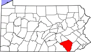
Bainbridge is an unincorporated community and census-designated place (CDP) in Conoy Township, Lancaster County, Pennsylvania, United States, with a ZIP code of 17502. Bainbridge is located along Pennsylvania Route 441. As of the 2010 census the popululation was 1,355.[2]
Bainbridge, Pennsylvania | |
|---|---|
 Bainbridge Location in Pennsylvania  Bainbridge Location in the United States | |
| Coordinates: 40°05′27″N 76°40′03″W | |
| Country | United States |
| State | Pennsylvania |
| County | Lancaster |
| Township | Conoy |
| Area | |
| • Total | 2.30 sq mi (5.96 km2) |
| • Land | 2.28 sq mi (5.91 km2) |
| • Water | 0.02 sq mi (0.05 km2) |
| Elevation | 310 ft (90 m) |
| Population | |
| • Total | 1,355 |
| • Density | 594/sq mi (229.4/km2) |
| Time zone | UTC-5 (Eastern (EST)) |
| • Summer (DST) | UTC-4 (EDT) |
| ZIP code | 17502 |
| Area code(s) | 717 and 223 |
| FIPS code | 42-03800 |
| GNIS feature ID | 1168585 |
Prior to European settlement, Bainbridge was the site of a Conoy village in the first decades of the 18th century, possibly called Conejoholo.[3][4]
History
Bainbridge became home to the Conoy and Nanticoke tribes in the early 1700s when English settlers pushed them out of their original homes. Prior to the move, the Conoys lived in the area that is now Baltimore, and the Nanticokes lived across the Chesapeake Bay in what is now Delaware. In 1632 there were about 2,500 among the tribes, and by 1697 there were only about 300 due to diseases brought over by the English.
Geography
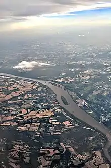
Bainbridge is in western Lancaster County, in the southern part of Conoy Township. Pennsylvania Route 441 passes through the community northeast of the downtown, leading northwest (upstream along the Susquehanna River) 9 miles (14 km) to Middletown and southeast (downstream) 10 miles (16 km) to Columbia.
According to the U.S. Census Bureau, the Bainbridge CDP has a total area of 2.3 square miles (6.0 km2), of which 0.02 square miles (0.05 km2), or 0.85%, are water.[1]
Tourism
White Cliffs
The White Cliffs of Conoy, south of Bainbridge, are quite old, but have only recently been open to the public. The cliffs look out over the Susquehanna River and are the direct result of a limestone quarry.
References
- "2019 U.S. Gazetteer Files: Places: Pennsylvania". United States Census Bureau. Retrieved September 14, 2020.
- "Total Population: 2010 Census DEC Summary File 1 (P1), Bainbridge CDP, Pennsylvania". data.census.gov. U.S. Census Bureau. Retrieved September 14, 2020.
- "NPAP Where/When Demo Opening Map Page". Hiddenhistory.com. Retrieved 2013-12-25.
- "C- Pennsylvania Indian Villages, Towns and Settlements". Access Genealogy. 2013-10-18. Retrieved 2013-12-25.