Mount Joy Township, Lancaster County, Pennsylvania
Mount Joy Township is a township in northwestern Lancaster County, Pennsylvania, United States. The population was 9,873 at the 2010 census.
Mount Joy Township, Lancaster County, Pennsylvania | |
|---|---|
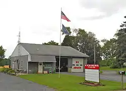 Mt. Joy Township Forest Fire Co. | |
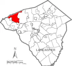 Map of Lancaster County highlighting Mount Joy Township | |
| Country | United States |
| State | Pennsylvania |
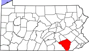
| County | Lancaster |
| Settled | 1735 |
| Incorporated | 1759 |
| Government | |
| • Type | Board of Supervisors |
| Area | |
| • Total | 28.02 sq mi (72.56 km2) |
| • Land | 27.84 sq mi (72.09 km2) |
| • Water | 0.18 sq mi (0.47 km2) |
| Population (2010) | |
| • Total | 9,873 |
| • Estimate (2016)[2] | 10,800 |
| • Density | 387.99/sq mi (149.80/km2) |
| Time zone | UTC-5 (Eastern (EST)) |
| • Summer (DST) | UTC-4 (EDT) |
| Area code(s) | 717 |
| FIPS code | 42-071-51664 |
| Website | www |
Geography
According to the United States Census Bureau, the township has a total area of 28.0 square miles (72.4 km2), all of it recorded as land. The borough of Elizabethtown borders the township to the southwest, and the borough of Mount Joy borders the southern end of the township. Unincorporated communities in the township include Bellaire, Aberdeen, Milton Grove, Anchor, and part of Rheems.
Demographics
| Historical population | |||
|---|---|---|---|
| Census | Pop. | %± | |
| 1850 | 2,626 | — | |
| 1860 | 2,150 | −18.1% | |
| 1870 | 2,037 | −5.3% | |
| 1880 | 2,554 | 25.4% | |
| 1890 | 2,258 | −11.6% | |
| 1900 | 2,252 | −0.3% | |
| 1910 | 2,222 | −1.3% | |
| 1920 | 2,022 | −9.0% | |
| 1930 | 2,286 | 13.1% | |
| 1940 | 2,729 | 19.4% | |
| 1950 | 3,086 | 13.1% | |
| 1960 | 4,135 | 34.0% | |
| 1970 | 4,228 | 2.2% | |
| 1980 | 5,131 | 21.4% | |
| 1990 | 6,227 | 21.4% | |
| 2000 | 7,944 | 27.6% | |
| 2010 | 9,873 | 24.3% | |
| 2016 (est.) | 10,800 | [2] | 9.4% |
| U.S. Decennial Census[3] | |||
As of the census[4] of 2010, there were 9,873 people, 3,621 households, and 2,810 families living in the township. The population density was 354.6 people per square mile. There were 3,768 housing units. The racial makeup of the township was 95.3% White, 1.1% African American, 0.1% Native American, 1.0% Asian, 1.0% from other races, and 1.5% from two or more races. Hispanic or Latino of any race were 2.9% of the population.
There were 3,621 households, out of which 35.0% had children under the age of 18 living with them, 65.5% were married couples living together, 8.4% had a female householder with no husband present, and 22.4% were non-families. 17.4% of all households were made up of individuals, and 5.4% had someone living alone who was 65 years of age or older. The average household size was 2.73 and the average family size was 3.07.
In the township the population was spread out, with 26.0% under the age of 18 and 11.4% who were 65 years of age or older. The median age was 37.4 years.
Government and infrastructure
The Pennsylvania Department of Corrections Training Academy is located in the township.[5][6]
Education
The township is served by the Elizabethtown Area School District[7] and Donegal School District.[8]
References
- "2016 U.S. Gazetteer Files". United States Census Bureau. Retrieved Aug 14, 2017.
- "Population and Housing Unit Estimates". Retrieved June 9, 2017.
- "Census of Population and Housing". Census.gov. Retrieved June 4, 2016.
- "U.S. Census website". United States Census Bureau. Retrieved 2008-01-31.
- "Zoning Map." (Archive) Mount Joy Township. Retrieved on October 5, 2012.
- "Pennsylvania Department of Corrections Training Academy." Pennsylvania Department of Corrections. Retrieved on October 5, 2012. "1451 North Market Street Elizabethtown, PA 17022"
- "About the Community". Elizabethtown Area School District. Retrieved 2 February 2015.
- "Donegal School District". Donegal School District. Retrieved 2 February 2015.