Bamanpukur
Bamanpukur is a census town in the Nabadwip CD block in the Krishnanagar Sadar subdivision of the Nadia district in the state of West Bengal, India.
Bamanpukur | |
|---|---|
Census Town | |
 Bamanpukur Location in West Bengal, India  Bamanpukur Bamanpukur (India) | |
| Coordinates: 23.445394°N 88.405317°E | |
| Country | |
| State | West Bengal |
| District | Nadia |
| Area | |
| • Total | 3.1022 km2 (1.1978 sq mi) |
| Population (2011) | |
| • Total | 9,137 |
| • Density | 2,900/km2 (7,600/sq mi) |
| Languages | |
| • Official | Bengali, English |
| Time zone | UTC+5:30 (IST) |
| PIN | 741313 |
| Telephone/STD code | 03472 |
| Lok Sabha constituency | Ranaghat |
| Vidhan Sabha constituency | Nabadwip |
| Website | nadia |
Geography
| Cities and towns in Krishnanagr Sadar subdivision of Nadia district M: municipal town/ city, CT: census town, R: rural/ urban centre, H: place of historical/ religious interest, T: place of tourist interest. Owing to space constraints in the small map, the actual locations in a larger map may vary slightly |
Location
Bamanpukur is located at 23.445394°N 88.405317°E.
Area overview
Nadia district is mostly alluvial plains lying to the east of Hooghly River, locally known as Bhagirathi. The alluvial plains are cut across by such distributaries as Jalangi, Churni and Ichhamati. With these rivers getting silted up, floods are a recurring feature.[1] The Krishnanagar Sadar subdivision, presented in the map alongside, has the Bhagirathi on the west, with Purba Bardhaman district lying across the river. The long stretch along the Bhagirathi has many swamps. The area between the Bhagirathi and the Jalangi, which flows through the middle of the subdivision, is known as Kalantar, a low-lying tract of black clay soil. A big part of the subdivision forms the Krishnanagar-Santipur Plain, which occupies the central part of the district. The Jalangi, after flowing through the middle of the subdivision, turns right and joins the Bhagirathi. On the south-east, the Churni separates the Krishnanagar-Santipur Plain from the Ranaghat-Chakdaha Plain. The east forms the boundary with Bangladesh.[2] The subdivision is moderately urbanized. 20.795% of the population lives in urban areas and 79.205% lives in rural areas.[3]
Note: The map alongside presents some of the notable locations in the subdivision. All places marked in the map are linked in the larger full screen map. All the four subdivisions are presented with maps on the same scale – the size of the maps vary as per the area of the subdivision.
Demographics
According to the 2011 Census of India, Bamanpukur had a total population of 9,137, of which 4,656 (51%) were males and 4,481 (49%) were females. Population in the age range 0–6 years was 957. The total number of literate persons in Bamanpukur was 6,262 (76.55% of the population over 6 years).[4]
Infrastructure
According to the District Census Handbook 2011, Nadia, Bamanpukur covered an area of 3.1022 km2. Among the civic amenities, the protected water supply involved tap water from untreated sources. It had 1,200 domestic electric connections, 100 road light points. Among the medical facilities it had 2 medicine shops. Among the educational facilities it had were 6 primary school, 2 secondary schools, 1 senior secondary school. Three important commodities it produced were rice, wheat, mustard oil. It had the branch office of 1 nationalised bank.[5]
Ballal Dhipi
Ballal Dhipi in Bamanpukur, is an ancient site, which has been excavated by the Archaeological Survey of India that indicates the existence of a Buddhist vihara dating back to 10-12th century or earlier.[6][7] Two separate sites are identified as Monuments of National Importance.[8]
Ballal Dhipi picture gallery
_20180728_111713.jpg.webp) Popular traditionally as Bamanpukur mound, these are now a part of Ballal Dhipi
Popular traditionally as Bamanpukur mound, these are now a part of Ballal Dhipi_20180728_111204.jpg.webp) It was earlier thought of as the remains of a fort
It was earlier thought of as the remains of a fort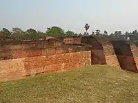 Ballal Dhipi: A part of the extensive structural complex
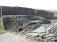 Ballal Dhipi: A part of the extensive structural complex
Education
Bamanpukur High School is a Bengali-medium coeducational institution established in 1921. It has facilities for teaching from class V to class XII. The school has a library with 1,650 books, 18 computers and a play ground.[9]
References
- Gangopadhyay, Basudev, Paschimbanga Parichay, 2001, (in Bengali), p. 70, Sishu Sahitya Sansad
- "District Census Handbook, Nadia, 2011, Series 20, Part XII A" (PDF). Pages 13,14. Directorate of Census Operations, West Bengal. Retrieved 15 October 2020.
- "District Statistical Handbook 2014 Nadia". Table 2.2, 2.4(a). Department of Planning and Statistics, Government of West Bengal. Retrieved 15 October 2020.
- "2011 Census – Primary Census Abstract Data Tables". West Bengal – District-wise. Registrar General and Census Commissioner, India. Retrieved 2 October 2020.
- "District Census Handbook Nadia, Census of India 2011, Series 20, Part XII A" (PDF). Section II Town Directory, Pages 635-656; Statement I: Status and Growth History, Page 635; Statement II: Physical Aspects and Location of Towns, Page 641; Statement III: Civic and other Amenities, Page 643; Statement IV: Medical Facilities, Page 646; Statement V: Educational, Recreational and Cultural Facilities, Page 655; Statement VI:Industry and Banking ,Page 2833. Directorate of census Operations V, West Bengal. Retrieved 30 September 2020.
- "Mound known as Bamanpukur Mound of Fort". ASI, Kolkata Circle. Retrieved 18 October 2020.
- "Pilgrimages & Tourist Spots". Ballal Dhipi. Egiye Bangla, official website of Nadia district. Retrieved 18 October 2020.
- "List of Ancient Monuments and Archaeological Sites and Remains of West Bengal - Archaeological Survey of India". Item nos. 130&131. ASI. Retrieved 18 October 2020.
- "Bamanpukur High School". Schools.org.in. Retrieved 19 October 2020.
Cities, towns and locations in Nadia District | |||||||||
|---|---|---|---|---|---|---|---|---|---|
| Cities, municipal and census towns |
| ||||||||
| Locations other than cities and towns |
| ||||||||
| Related topics |
| ||||||||
