Habibpur, Nadia
Habibpur is a village in the Ranaghat I CD block in the Ranaghat subdivision of the Nadia district, west Bengal, India
Habibpur | |
|---|---|
Village | |
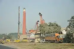 A rice mill | |
 Habibpur Location in West Bengal, India  Habibpur Habibpur (India) | |
| Coordinates: 23.176376°N 88.516123°E | |
| Country | |
| State | West Bengal |
| District | Nadia |
| Population | |
| • Total | 13,383 |
| Languages | |
| • Official | Bengali, English |
| Time zone | UTC+5:30 (IST) |
| Telephone code | 03473 |
| Vehicle registration | WB- |
| Nearest city | Ranaghat |
| Lok Sabha constituency | Ranaghat |
| Climate | Tropical monsoon (Köppen) |
| Avg. summer temperature | 35 °C (95 °F) |
| Avg. winter temperature | 20 °C (68 °F) |
Geography
| Cities and towns in Ranaghat subdivision of Nadia district M: municipal town/ city/notified area, CT: census town, R: rural/ urban centre. Owing to space constraints in the small map, the actual locations in a larger map may vary slightly |
Location
Habibpur is located at 23.176376°N 88.516123°E.
The maps of Ranaghat I and Ranaghat II CD blocks, in the District Census Handbook 2011, Nadia, shows the census towns of Kamgachhi, Raghabpur, Panpara, Aistala, Satigachha, Anulia, Halalpur Krishnapur, Hijuli and Ranaghat (CT) forming a cluster around Ranaghat. Certain other localitites such as Nokari, Nasra, Cooper's Camp, Birnagar, Habibpur, Gopalpur and Parbbatipur are also linked with this cluster.[1]
Area overview
Nadia district is mostly alluvial plains lying to the east of Hooghly River, locally known as Bhagirathi. The alluvial plains are cut across by such distributaries as Jalangi, Churni and Ichhamati. With these rivers getting silted up, floods are a recurring feature.[2] The Ranaghat subdivision has the Bhagirathi on the west, with Purba Bardhaman and Hooghly districts lying across the river. Topographically, Ranaghat subdivision is spread across the Krishnanagar-Santipur Plain, which occupies the central part of the district, and the Ranaghat-Chakdaha Plain, the low-lying area found in the south-eastern part of the district. The Churni separates the two plains. A portion of the east forms the boundary with Bangladesh. The lower portion of the east is covered by a portion of the North 24 Parganas district.[3] The subdivision has achieved reasonably high urbanisation. 41.68% of the population lives in urban areas and 58.32% lives in rural areas.[4]
Note: The map alongside presents some of the notable locations in the subdivision. All places marked in the map are linked in the larger full screen map. All the four subdivisions are presented with maps on the same scale – the size of the maps vary as per the area of the subdivision.
Demographics
According to the 2011 Census of India, Habibpur had a total population of 13,383, of which 6,924 (52%) were males and 6,459 (48%) were females. Population in the age range 0–6 years was 1,314. The total number of literate persons in Habibpur was 9,547 (79.10% of the population over 6 years).[5]
Civic administration
CD block HQ
The headquarters of Ranaghat I CD block are located at Habibpur.[6]
Transport
Habibpur railway station is situated on Ranaghat-Santipur branch line of Sealdah railway division.[7]
Healthcare
Habibpur (Jadav Dutta) Rural Hospital, with 30 beds at Habibpur, is the major government medical facility in the Ranaghat I CD block.[8]
References
- "District Census Handbook Nadia, Census of India 2011, Series 20, Part XII A" (PDF). Map of Ranaghat I CD block, page 449, and Map of Ranaghat II CD block, page 475. Directorate of census Operations V, West Bengal. Retrieved 8 October 2020.
- Gangopadhyay, Basudev, Paschimbanga Parichay, 2001, (in Bengali), p. 70, Sishu Sahitya Sansad
- "District Census Handbook, Nadia, 2011, Series 20, Part XII A" (PDF). Pages 13,14. Directorate of Census Operations, West Bengal. Retrieved 16 October 2020.
- "District Statistical Handbook 2014 Nadia". Table 2.2, 2.4(a). Department of Planning and Statistics, Government of West Bengal. Retrieved 16 October 2020.
- "2011 Census – Primary Census Abstract Data Tables". West Bengal – District-wise. Registrar General and Census Commissioner, India. Retrieved 6 October 2020.
- "District Census Handbook: Nadia, Series 20 Part XII A" (PDF). Map of Nadia with CD Block HQs and Police Stations (on the fourth page). Directorate of Census Operations, West Bengal, 2011. Retrieved 6 October 2020.
- "Habibpur Railway Station (HBE) : Station Code, Time Table, Map, Enquiry". www.ndtv.com. Retrieved 21 August 2020.
- "Health & Family Welfare Department" (PDF). Health Statistics – Rural Hospitals. Government of West Bengal. Retrieved 6 October 2020.
Cities, towns and locations in Nadia District | |||||||||
|---|---|---|---|---|---|---|---|---|---|
| Cities, municipal and census towns |
| ||||||||
| Locations other than cities and towns |
| ||||||||
| Related topics |
| ||||||||