Nadia district
Nadia district (pronounced [nɔd̪iːaː]) is a district in the state of West Bengal, India. It borders Bangladesh to the east, North 24 Parganas and Hooghly districts to the south, Purba Bardhaman to the west, and Murshidabad to the north.
Nadia district | |
|---|---|
District of West Bengal | |
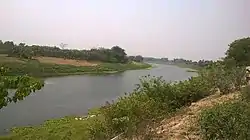 Jalangi river near Palashipara | |
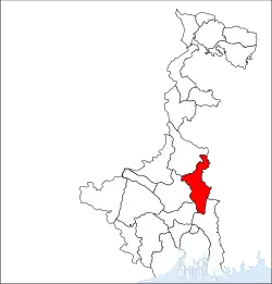 Location of Nadia district in West Bengal | |
| Country | |
| State | |
| Division | Presidency |
| Headquarters | Krishnanagar |
| Government | |
| • Lok Sabha constituencies | Krishnanagar, Ranaghat Some of area covered with Bangaon, North part is in Murshidabad Lok Shaba. |
| • Vidhan Sabha constituencies | Karimpur, Tehatta, Palashipara, Kaliganj, Nakashipara, Chapra, Krishnanagar Uttar, Nabadwip, Krishnanagar Dakshin, Santipur, Ranaghat Uttar Paschim, Krishnaganj, Ranaghat Uttar Purba, Ranaghat Dakshin, Chakdaha, Kalyani, Haringhata |
| Area | |
| • Total | 3,927 km2 (1,516 sq mi) |
| Population (2011) | |
| • Total | 5,167,601 |
| • Density | 1,300/km2 (3,400/sq mi) |
| • Urban | 979,519 |
| Demographics | |
| • Literacy | 75.58 per cent[1] |
| • Sex ratio | 947 |
| Time zone | UTC+05:30 (IST) |
| Major highways | NH 12 State Highway 11 |
| Website | http://nadia.nic.in/ |
History
Nabadwip, an ancient town within Nadia district, is often referred to as “Oxford of Bengal”.[2] Chaitanya Mahaprabhu (b.1486–d.1534) was born in Nabadwip.[3] One of the Indian schools of logic (Tarka sastra) called Navya Nyaya system was developed in Nabadwip, which produced great logicians in the 15th century. Nabadwip was an important seat of political power and the capital of Bengal under Ballal Sen and later Lakshman Sen, kings of the Sena Empire, who ruled from 1159 to 1206.[3] In 1202, Nabadwip was captured by Bakhtiyar Khilji. This victory paved the way for Muslim rule in Bengal.[4]
Demographics
| Year | Pop. | ±% p.a. |
|---|---|---|
| 1901 | 771,672 | — |
| 1911 | 774,459 | +0.04% |
| 1921 | 710,455 | −0.86% |
| 1931 | 720,944 | +0.15% |
| 1941 | 839,308 | +1.53% |
| 1951 | 1,142,686 | +3.13% |
| 1961 | 1,711,830 | +4.12% |
| 1971 | 2,223,911 | +2.65% |
| 1981 | 2,964,253 | +2.92% |
| 1991 | 3,852,097 | +2.65% |
| 2001 | 4,604,827 | +1.80% |
| 2011 | 5,167,600 | +1.16% |
| source:[5] | ||
According to the 2011 census Nadia district has a population of 5,167,600,[6] roughly equal to the US state of Colorado.[7] This gives it a ranking of 18th in India (out of a total of 640).[6] The district has a population density of 1,316 inhabitants per square kilometre (3,410/sq mi) .[6] Its population growth rate over the decade 2001-2011 was 12.24%.[6] Nadia has a sex ratio of 947 females for every 1000 males,[6] and a literacy rate of 75.58%. Scheduled Castes and Scheduled Tribes make up 29.9% and 2.7% of the population respectively.[6]
Governance
District Administration
The District of Nadia has its headquarter at Krishnanagar town. The British district of Nadia was formed in 1787. The present district of Nadia after partition was formed by Notification No.545-GA dated 23 February 1948. The District Administration is headed by the District Magistrate & District Collector, Nadia.
Administrative subdivisions
The district comprises four subdivisions: Krishnanagar Sadar, Kalyani, Ranaghat and Tehatta. Krishnanagar Sadar subdivision consists of Krishnanagar municipality, Nabadwip municipality and seven community development blocks: Kaliganj, Nakashipara, Chapra, Krishnanagar–I, Krishnanagar–II, Nabadwip and Krishnaganj. Kalyani subdivision consists of Chakdaha municipality, Gayespur municipality, Kalyani municipality and 3 community development blocks: Kalyani, Chakdaha and Haringhata. Ranaghat subdivision consists of Shantipur municipality, Ranaghat municipality, Birnagar municipality and four community development blocks: Hanskhali, Shantipur, Ranaghat–I and Ranaghat–II. Tehatta subdivision consists of four community development blocks: Karimpur–I, Karimpur–II, Tehatta–I and Tehatta–II.[11] Krishnanagar is the district headquarters. There are 19 police stations, 2 womens and 1 cyber crime P.s, 17 development blocks, 11 municipalities, 187 gram panchayats (3114 sets) and 2639 villages in this district.[11][12]
Other than municipality area, each subdivision contains community development blocks which in turn are divided into rural areas and census towns. In total there are 29 urban units: 8 municipalities and 15 census towns and two notified areas.[13] Ranaghat, Aistala, Satigachha, Nasra and Cooper's Camp together forms Ranaghat urban agglomeration. Nabadwip, Char Maijdia and Char Brahmanagar forms Nabadwip UA. Chakdaha, Gopalpur and Parbbatipur forms Chakdaha UA. Krishnanagar and Badkulla together forms Krishnanagar UA. Birnagar, Phulia and Taherpur together forms Birnagar UA.
Krishnanagar Sadar subdivision
- Krishnanagar: municipality
- Nabadwip: municipality
- Kaliganj (Community development block) consists of rural areas only with 15 gram panchayats.
- Nakashipara (Community development block) consists of rural areas with 15 gram panchayats and two census town: Jagadanandapur and Kshidirpur.
- Chapra, Nadia (Community development block) consists of rural areas with only 13 gram panchayats.
- Krishnanagar I (Community development block) consists of rural areas with 12 gram panchayats and one census town: Baruihuda.
- Krishnanagar II (Community development block) consists of rural areas only with 7 gram panchayats.
- Nabadwip (Community development block) consists of rural areas with 8 gram panchayats and three census towns: Bablari Dewanganj, Char Maijdia and Char Brahmanagar.
- Krishnaganj (Community development block) consists of rural areas only with 7 gram panchayats.
Kalyani subdivision
- Chakdaha: municipality
- Kalyani: municipality
- Gayespur: municipality
- Haringhata: municipality
- Chakdaha (Community development block) consists of rural areas with 10 gram panchayats and two census towns: Darappur and Madanpur.
- Kalyani (Community development block) consists of rural areas only with 7 gram Panchayats.
- Haringhata (Community development block) consists of rural areas only with 10 gram panchayats.
Ranaghat subdivision
- Shantipur: municipality
- Ranaghat: municipality
- Birnagar: municipality
- Taherpur: municipality
- Cooper's Camp: municipality
- Badkulla: gram panchayet
- Hanskhali (Community development block) consists of rural areas only with 13 gram panchayats.
- Santipur (Community development block) consists of rural areas with 10 gram panchayats and one census town, Phulia.
- Ranaghat I (Community development block) consists of rural areas with 10 gram panchayats and four census towns: Aistala, Satigachha, Gopalpur and Parbbatipur
- Ranaghat II (Community development block) consists of rural areas with 14 gram panchayats and one census town: Nasra
Tehatta subdivision
- Karimpur I (Community development block) consists of rural areas with 8 gram panchayats and one census town: Karimpur.
- Karimpur II (Community development block) consists of rural areas only with 10 gram panchayats.
- Tehatta I (Community development block) consists of rural areas only with 11 gram panchayats.
- Tehatta II (Community development block) consists of rural areas only with 7 gram panchayats.
Assembly constituencies
The district is divided into 17 assembly constituencies:[14]
- Karimpur (assembly constituency no. 77),
- Tehatta (assembly constituency no. 78),
- Palashipara (assembly constituency no. 79),
- Kaliganj (assembly constituency no. 80),
- Nakshipara (assembly constituency no. 81),
- Chapra (assembly constituency no. 82),
- Krishnanagar Uttar (assembly constituency no. 83),
- Nabadwip (assembly constituency no. 84),
- Krishnanagar Dakshin (assembly constituency no. 85),
- Santipur (assembly constituency no. 86),
- Ranaghat Uttar Paschim (assembly constituency no. 87),
- Krishnaganj (SC) (assembly constituency no. 88),
- Ranaghat Uttar Purba (SC) (assembly constituency no. 89),
- Ranaghat Dakshin (SC) (assembly constituency no. 90),
- Chakdaha (assembly constituency no. 91),
- Kalyani (SC) (assembly constituency no. 92) and
- Haringhata (SC) (assembly constituency no. 93).
Krishnaganj, Ranaghat Dakshin, Kalyani, Haringhata, Ranaghat Uttar Purba and Kaliganj constituencies are reserved for Scheduled Castes (SC) candidates. Along with six assembly constituencies from Murshidabad district, Karimpur assembly constituency forms the Murshidabad (Lok Sabha constituency). Palashipara, Nakashipara, Kaliganj, Chapra, Krishnaganj, Krishnanagar East and Krishnanagar West constituencies form the Krishnagar (Lok Sabha constituency). Nabadwip, Shantipur, Hanskhali, Ranaghat East, Ranaghat West, Chakdaha and Haringhata assembly constituencies form the Nabadwip (Lok Sabha constituency), which is reserved for Scheduled Castes (SC) candidates.
Impact of delimitation of constituencies
As per order of the Delimitation Commission in respect of the delimitation of constituencies in the West Bengal, the district will be divided into 17 assembly constituencies:[15]
| Sl. No. | Assembly Name | Reservation | Constituency no. |
|---|---|---|---|
| 1 | Karimpur | N/A | 77 |
| 2 | Tehatta | 78 | |
| 3 | Palashipara | 79 | |
| 4 | Kaliganj | 80 | |
| 5 | Nakshipara | 81 | |
| 6 | Chapra | 82 | |
| 7 | Krishnanagar Uttar | 83 | |
| 8 | Nabadwip | 84 | |
| 9 | Krishnanagar Dakshin | 85 | |
| 10 | Santipur | 86 | |
| 11 | Ranaghat Uttar Paschim | 87 | |
| 12 | Krishnaganj | SC | 88 |
| 13 | Ranaghat Uttar Purba | SC | 89 |
| 14 | Ranaghat Dakshin | SC | 90 |
| 15 | Chakdaha | N/A | 91 |
| 16 | Kalyani | SC | 92 |
| 17 | Haringhata | SC | 93 |
Flora and fauna
In 1980, Nadia district became home to the Bethuadahari Wildlife Sanctuary, which has an area of 0.7 km2 (0.3 sq mi).[16]
Education
University
- (Moulana Abul Kalam Azad University of technology)
College
- Tehatta Government ITI College, Tehatta
- Tehatta Government College, Tehatta
- Kaliganj Government College, Debagram
- Karimpur Pannadevi College, Karimpur
- Srikrishna College, Bagula
- Sudhiranjan Lahiri Mahavidyalaya, Majhdia
- Santipur College, Santipur
- Ranaghat College, Ranaghat
- Ranaghat Government Polytechnic, Ranaghat
- Nabadwip Vidyasagar College, Nabadwip
- Krishnagar Government College, Krishnanagar
- Krishnagar Women's College, Krishnanagar
- Haringhata Mahavidyalaya, Haringhata
- Dwijendralal College, Krishnanagar
- Dr. B.R. Ambedkar College, Betai
- Chakdaha College, Chakdaha
- Plassey College, Plassey
- Pritilata Waddedar Mahavidyalaya, Panikhali
- Bipradas Pal Chowdhury Institute of Technology, Krishnanagar
- Asannagar Madan Mohan Tarkalankar College, Asannagar
- Bethuadahari College, Bethuadahri
- Chapra Bangaljhi Mahavidyalaya, Chapra
- Chapra Government College, Chapra
- Muragacha Government College, Muragachha
- Kalyani Mahavidyalaya, Kalyani
- Kalyani Government Engineering College, Kalyani
- College of Medicine & JNM Hospital, Kalyani
Private College
- Global Institute of Management and Technology, Krishnanagar
- JIS College of Engineering, Kalyani
- Ideal Institute of Engineering, Kalyani
- Matiary B.Ed collage, Matiary
Transport
Rail
Nabadwip Dham is 65 km from Bandel, 105 km from Howrah and 112 km from Sealdah on the Bandel-Katwa-Azimganj (B.A.K Loop Line) section of Eastern Railway.[17] It has three Railway Stations as Nabadwip Dham railway station (NDAE), Bishnupriya (VSPR) of Howrah Division and Nabadwip Ghat (NDF) of Sealdah Division.
Krishnanagar City Junction is 100 km from Sealdah on the Sealdah-Lalgola Section of Eastern Railway.
Kalinarayanpur Junction is 78 km from Sealdah on the Sealdha-Lalgola section of Eastern Railway.
Ranaghat Junction is 74 km from Sealdah on the Sealdah-Lalgola Section of Eastern Railway.
Notable people
- Basanta Kumar Biswas, Independence revolutionary
- Dwijendralal Ray, poet, playwright and lyricist
- Ramtanu Lahiri, social reformer
- Bagha Jatin, Bengali revolutionary
- Soumitra Chatterjee, Actor, dramatist
- Lalon Shah, Sufi saint, philosopher, social reformer
- Sudhir Chakraborty, educator
- Jyotirmoyee Sikdar, Athlete
- Azizul Haque (educator),Advocate, diplomat
- Soma Biswas, Athlete
- Jhulan Goswami, Cricketer
- Hemanta Kumar Sarkar, philologist, author, leader of freedom Movement
- Subhash Mukhopadhyay, poet
- Dr. Sudhir Chakraborty, Educationist and Essayist
- Basanta Singha Roy, mountaineer, climbed Mount Everest in 2010.[18]
- Mohammad Mozammel Huq,Poet, Journalist
- Chaitanya Mahaprabhu, Bengali Hindu mystic, saint,Bhakti yoga, Achintya Bheda Abheda
- Gopal Bhar,Courtier and jester
- Krittibas Ojha ,medieval Bengali poet
- Jatindramohan Bagchi,Poet, editor
- Madan Mohan Tarkalankar,Poet, Sanskrit scholar
- Shibsankar Bandopadhyay, educationist and freedom fighter
References
- "District-specific Literates and Literacy Rates, 2001". Registrar General, India, Ministry of Home Affairs. Retrieved 10 October 2010.
- Cotton, H.E.A., Calcutta Old and New, 1909/1980, p1, General Printers and Publishers Pvt. Ltd.
- Official district website
- Tourist Department Archived 9 February 2010 at the Wayback Machine
- Decadal Variation In Population Since 1901
- "District Census 2011". Census2011.co.in. 2011. Retrieved 30 September 2011.
- "2010 Resident Population Data". U.S. Census Bureau. Retrieved 30 September 2011.
Colorado 5,029,196
- "Nadia Religion 2011". Retrieved 22 March 2017.
- http://www.censusindia.gov.in/2011census/C-16.html
- "DISTRIBUTION OF THE 22 SCHEDULED LANGUAGES-INDIA/STATES/UNION TERRITORIES - 2011 CENSUS" (PDF).
- "Directory of District, Sub division, Panchayat Samiti/ Block and Gram Panchayats in West Bengal, March 2008". West Bengal. National Informatics Centre, India. 19 March 2008. Archived from the original on 25 February 2009. Retrieved 30 November 2008.
- "District Profile". Official website of the Nadia district. Archived from the original on 17 January 2009. Retrieved 30 November 2008.
- "Population, Decadal Growth Rate, Density and General Sex Ratio by Residence and Sex, West Bengal/ District/ Sub District, 1991 and 2001". West Bengal. Directorate of census operations. Retrieved 12 November 2008.
- "General election to the Legislative Assembly, 2001 – List of Parliamentary and Assembly Constituencies" (PDF). West Bengal. Election Commission of India. Archived from the original (PDF) on 4 May 2006. Retrieved 22 November 2008.
- "Press Note, Delimitation Commission" (PDF). Assembly Constituencies in West Bengal. Delimitation Commission. Retrieved 22 November 2008.
- Indian Ministry of Forests and Environment. "Protected areas: West Bengal". Archived from the original on 23 August 2011. Retrieved 25 September 2011.
- Eastern Railway time table.
- https://m.telegraphindia.com/entertainment/mountain-man/cid/1667830
External links
| Wikimedia Commons has media related to Nadia district. |
Cities, towns and locations in Nadia District | |||||||||
|---|---|---|---|---|---|---|---|---|---|
| Cities, municipal and census towns |
| ||||||||
| Locations other than cities and towns |
| ||||||||
| Related topics |
| ||||||||