Bancroft, South Dakota
Bancroft is a town in northwest Kingsbury County, South Dakota, United States. The population was 19 at the 2010 census.
Bancroft, South Dakota | |
|---|---|
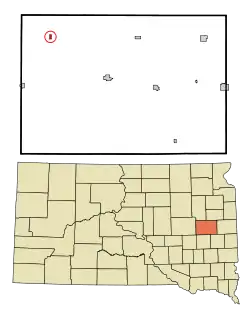 Location in Kingsbury County and the state of South Dakota | |
| Coordinates: 44°29′17″N 97°45′00″W[1] | |
| Country | United States |
| State | South Dakota |
| County | Kingsbury |
| Area | |
| • Total | 0.23 sq mi (0.60 km2) |
| • Land | 0.23 sq mi (0.60 km2) |
| • Water | 0.00 sq mi (0.00 km2) |
| Elevation | 1,572 ft (479 m) |
| Population | |
| • Total | 19 |
| • Estimate (2019)[4] | 19 |
| • Density | 81.55/sq mi (31.55/km2) |
| Time zone | UTC-6 (Central (CST)) |
| • Summer (DST) | UTC-5 (CDT) |
| ZIP code | 57353 |
| Area code(s) | 605 |
| FIPS code | 46-03420[5] |
History
Bancroft had its start in the late 1880s when the railroad was extended to that point.[6] The town most likely was named after L. L. Bancroft, a local newspaper publisher.[6] A post office was established at Bancroft in 1889.[7]
Geography
Bancroft is located on the west bank of Redstone Creek and approximately seven miles north of U.S. Route 14.[8]
According to the United States Census Bureau, the town has a total area of 0.23 square miles (0.60 km2), all of it land.[9]
Demographics
| Historical population | |||
|---|---|---|---|
| Census | Pop. | %± | |
| 1910 | 136 | — | |
| 1920 | 141 | 3.7% | |
| 1930 | 155 | 9.9% | |
| 1940 | 126 | −18.7% | |
| 1950 | 100 | −20.6% | |
| 1960 | 86 | −14.0% | |
| 1970 | 48 | −44.2% | |
| 1980 | 41 | −14.6% | |
| 1990 | 30 | −26.8% | |
| 2000 | 37 | 23.3% | |
| 2010 | 19 | −48.6% | |
| 2019 (est.) | 19 | [4] | 0.0% |
| U.S. Decennial Census[10] | |||
2010 census
As of the census[3] of 2010, there were 19 people, 10 households, and 6 families residing in the town. The population density was 82.6 inhabitants per square mile (31.9/km2). There were 13 housing units at an average density of 56.5 per square mile (21.8/km2). The racial makeup of the town was 94.7% White and 5.3% from two or more races.
There were 10 households, of which 10.0% had children under the age of 18 living with them, 60.0% were married couples living together, and 40.0% were non-families. 40.0% of all households were made up of individuals, and 30% had someone living alone who was 65 years of age or older. The average household size was 1.90 and the average family size was 2.50.
The median age in the town was 54.3 years. 15.8% of residents were under the age of 18; 0% were between the ages of 18 and 24; 26.3% were from 25 to 44; 26.4% were from 45 to 64; and 31.6% were 65 years of age or older. The gender makeup of the town was 42.1% male and 57.9% female.
2000 census
As of the census[5] of 2000, there were 37 people, 13 households, and 10 families residing in the town. The population density was 157.9 people per square mile (62.1/km2). There were 15 housing units at an average density of 64.0 per square mile (25.2/km2). The racial makeup of the town was 97.00% White.
There were 13 households, out of which 46.2% had children under the age of 18 living with them, 76.9% were married couples living together, and 15.4% were non-families. 15.4% of all households were made up of individuals, and 15.4% had someone living alone who was 65 years of age or older. The average household size was 2.85 and the average family size was 3.18.
In the town, the population was spread out, with 27.0% under the age of 18, 5.4% from 18 to 24, 27.0% from 25 to 44, 18.9% from 45 to 64, and 21.6% who were 65 years of age or older. The median age was 38 years. For every 100 females, there were 131.3 males. For every 100 females age 18 and over, there were 107.7 males.
The median income for a household in the town was $43,500, and the median income for a family was $44,000. Males had a median income of $23,333 versus $16,250 for females. The per capita income for the town was $14,753. None of the population or families were below the poverty line.
References
- "2019 U.S. Gazetteer Files". United States Census Bureau. Retrieved July 30, 2020.
- "U.S. Census website". United States Census Bureau. Retrieved 2012-06-21.
- "Population and Housing Unit Estimates". United States Census Bureau. May 24, 2020. Retrieved May 27, 2020.
- "U.S. Census website". United States Census Bureau. Retrieved 2008-01-31.
- Federal Writers' Project (1940). South Dakota place-names, v.1-3. University of South Dakota. p. 25.
- "Kingsbury County". Jim Forte Postal History. Retrieved 22 January 2015.
- Bancroft East, SD, 7.5 Minute Topographic Quadrangle, USGS 1971
- "US Gazetteer files 2010". United States Census Bureau. Archived from the original on January 12, 2012. Retrieved 2012-06-21.
- "Census of Population and Housing". Census.gov. Retrieved June 4, 2015.
Municipalities and communities of Kingsbury County, South Dakota, United States | ||
|---|---|---|
| Cities | 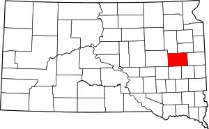 | |
| Towns | ||
| Unincorporated communities | ||
| Ghost town | ||
| Footnotes | ‡This populated place also has portions in an adjacent county or counties | |
| ||