Arlington, South Dakota
Arlington is a city in Brookings and Kingsbury counties in the State of South Dakota. The population was 915 at the 2010 census.
Arlington, South Dakota | |
|---|---|
 Location in Brookings County and the state of South Dakota | |
| Coordinates: 44°21′52″N 97°8′5″W | |
| Country | United States |
| State | South Dakota |
| Counties | Kingsbury, Brookings |
| Founded | 1880[1] |
| Area | |
| • Total | 1.72 sq mi (4.45 km2) |
| • Land | 1.72 sq mi (4.45 km2) |
| • Water | 0.00 sq mi (0.00 km2) |
| Elevation | 1,844 ft (562 m) |
| Population | |
| • Total | 915 |
| • Estimate (2019)[4] | 859 |
| • Density | 500.00/sq mi (193.06/km2) |
| Time zone | UTC-6 (Central (CST)) |
| • Summer (DST) | UTC-5 (CDT) |
| ZIP code | 57212 |
| Area code(s) | 605 |
| FIPS code | 46-02180 |
| GNIS feature ID | 1267666[5] |
| Website | www |
History
The city was platted by the Western Town Lot Company in 1880,[6] and originally named Nordland, with the platted streets given Norwegian names. The city was renamed a few years later, and in 1885 given the name of Arlington, after the colonial center in Virginia.[7] (It was briefly named Denver in the interlude, but postal authorities did not approve of the name.) The streets were not renamed until several decades passed, with Olaf Street eventually changed to Main Street, Kanut Street to Third Street, etc.
Geography
Arlington is at 44°21′52″N 97°8′5″W (44.364322, -97.134646),[8] primarily in Kingsbury County.
According to the United States Census Bureau, the city has a total area of 1.66 square miles (4.30 km2), all land.[9] Lake Poinsett is to the northeast.
Demographics
| Historical population | |||
|---|---|---|---|
| Census | Pop. | %± | |
| 1890 | 270 | — | |
| 1900 | 314 | 16.3% | |
| 1910 | 791 | 151.9% | |
| 1920 | 1,011 | 27.8% | |
| 1930 | 1,020 | 0.9% | |
| 1940 | 1,157 | 13.4% | |
| 1950 | 1,096 | −5.3% | |
| 1960 | 996 | −9.1% | |
| 1970 | 954 | −4.2% | |
| 1980 | 991 | 3.9% | |
| 1990 | 908 | −8.4% | |
| 2000 | 992 | 9.3% | |
| 2010 | 915 | −7.8% | |
| 2019 (est.) | 859 | [4] | −6.1% |
| U.S. Decennial Census[10] | |||
2010 census
As of the census[3] of 2010, there were 915 people, 420 households, and 243 families residing in the city. The population density was 551.2 inhabitants per square mile (212.8/km2). There were 489 housing units at an average density of 294.6 per square mile (113.7/km2). The racial makeup of the city was 97.4% White, 0.7% African American, 1.1% Native American, 0.1% Asian, 0.1% from other races, and 0.7% from two or more races. Hispanic or Latino of any race were 2.5% of the population.
There were 420 households, of which 23.8% had children under the age of 18 living with them, 48.8% were married couples living together, 6.2% had a female householder with no husband present, 2.9% had a male householder with no wife present, and 42.1% were non-families. 39.0% of all households were made up of individuals, and 18.5% had someone living alone who was 65 years of age or older. The average household size was 2.09 and the average family size was 2.77.
The median age in the city was 46 years. 21% of residents were under the age of 18; 5.2% were between the ages of 18 and 24; 22.4% were from 25 to 44; 27.9% were from 45 to 64; and 23.5% were 65 years of age or older. The gender makeup of the city was 50.4% male and 49.6% female.
2000 census
As of the census of 2000, there were 992 people, 424 households, and 262 families residing in the city. The population density was 635.6 people per square mile (245.5/km2). There were 473 housing units at an average density of 303.0 per square mile (117.1/km2). The racial makeup of the city was 98.49% White, 0.20% Native American, 0.71% Asian, and 0.60% from two or more races.
There were 424 households, out of which 25.5% had children under the age of 18 living with them, 54.2% were married couples living together, 5.2% had a female householder with no husband present, and 38.2% were non-families. 36.1% of all households were made up of individuals, and 22.9% had someone living alone who was 65 years of age or older. The average household size was 2.23 and the average family size was 2.90.
In the city, the population was spread out, with 21.9% under the age of 18, 6.8% from 18 to 24, 23.7% from 25 to 44, 18.2% from 45 to 64, and 29.4% who were 65 years of age or older. The median age was 43 years. For every 100 females, there were 90.8 males. For every 100 females age 18 and over, there were 84.1 males.
The median income for a household in the city was $34,688, and the median income for a family was $43,813. Males had a median income of $29,083 versus $19,531 for females. The per capita income for the city was $17,858. About 1.9% of families and 4.4% of the population were below the poverty line, including 5.8% of those under age 18 and 8.0% of those age 65 or over.
Education
Arlington Public Schools are part of the Arlington School District. The district has one elementary school, one junior high school and one high school.[11] Students attend Arlington High School.[12]
Media
The Arlington Sun has been published in Arlington since 1885.[13] It is a weekly newspaper currently published by Kenneth Reiste.[14]
Infrastructure
Transportation
The Arlington Municipal Airport is in Brookings County, two nautical miles (2.3 mi, 3.7 km) north of Arlington's central business district.[15]
Notable person
- Theodore Schultz, co-winner of the Nobel Prize in economics in 1979, was born in Arlington in 1902.[16] There is no mention nor memorial of Mr. Schultz within Arlington.
See also
References
- "SD Towns" (PDF). South Dakota State Historical Society. Archived from the original (PDF) on 10 February 2010. Retrieved 2010-02-10.
- "2019 U.S. Gazetteer Files". United States Census Bureau. Retrieved July 30, 2020.
- "U.S. Census website". United States Census Bureau. Retrieved 2012-06-21.
- "Population and Housing Unit Estimates". United States Census Bureau. May 24, 2020. Retrieved May 27, 2020.
- U.S. Geological Survey Geographic Names Information System: Arlington
- Chicago and North Western Railway Company (1908). A History of the Origin of the Place Names Connected with the Chicago & North Western and Chicago, St. Paul, Minneapolis & Omaha Railways. p. 39.
- Federal Writers' Project (1940). South Dakota place-names, v.1-3. University of South Dakota. p. 23.
- "US Gazetteer files: 2010, 2000, and 1990". United States Census Bureau. 2011-02-12. Retrieved 2011-04-23.
- "US Gazetteer files 2010". United States Census Bureau. Archived from the original on 2012-01-25. Retrieved 2012-06-21.
- "Census of Population and Housing". Census.gov. Retrieved June 4, 2016.
- "Arlington School District 38-1". education.com. Retrieved October 3, 2012.
- "Arlington School District". Arlington School District. Retrieved October 3, 2012.
- "The Arlington Sun". The Arlington Sun. Archived from the original on February 7, 2012. Retrieved October 3, 2012.
- "About The Arlington sun. (Arlington, S.D." Library of Congress. Retrieved October 3, 2012.
- FAA Airport Form 5010 for 3A9 PDF. Federal Aviation Administration. Effective 30 June 2011.
- "Theodore Schultz, 95, Winner Of a Key Prize in Economics". The New York Times. Retrieved October 3, 2012.
External links
| Wikimedia Commons has media related to Arlington, South Dakota. |
- Official website
- The Arlington Sun
- Arlington School District
- City-Data.com, comprehensive statistical data about Arlington
Municipalities and communities of Brookings County, South Dakota, United States | ||
|---|---|---|
| Cities | 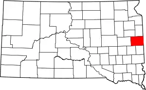 | |
| Towns | ||
| CDP | ||
| Other unincorporated communities | ||
| Townships |
| |
| Footnotes | ‡This populated place also has portions in an adjacent county or counties | |
| ||
Municipalities and communities of Kingsbury County, South Dakota, United States | ||
|---|---|---|
| Cities | 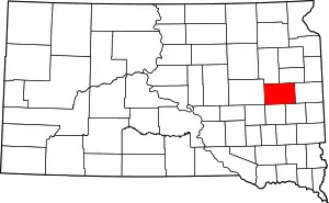 | |
| Towns | ||
| Unincorporated communities | ||
| Ghost town | ||
| Footnotes | ‡This populated place also has portions in an adjacent county or counties | |
| ||