Banggai Laut Regency
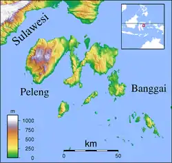
Banggai Laut Regency is a regency in the province of Central Sulawesi, Indonesia. The regency was established on 14 December 2012, partitioned from the Banggai Islands Regency.[1] It comprises the main island of Banggai itself (including 40 offshore islets), the islands of Labobo and Bangkurung to the west of Banggai Island, and the numerous small Bokan Islands (Kepulauan Bokan) to the southeast.
Banggai Laut Regency
Kabupaten Banggai Laut | |
|---|---|
 Coat of arms | |
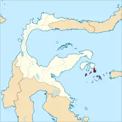 Location within Central Sulawesi | |
| Coordinates: 1.5888°S 123.5008°E | |
| Country | Indonesia |
| Region | Sulawesi |
| Province | Central Sulawesi |
| Capital | Banggai |
| Government | |
| • Regent | Wenny Bukamo |
| • Vice Regent | Tuty Hamid |
| Area | |
| • Total | 231.2 sq mi (598.8 km2) |
| Population (2010 Census) | |
| • Total | 62,163 |
| • Density | 270/sq mi (100/km2) |
| Time zone | UTC+8 (ICST) |
| Area code | (+62) 461 |
| Website | banggailautkab |

Administration
The new Banggai Laut Regency is composed of seven districts (kecamatan), tabulated below with their 2010 Census population:
| Name | Area in sq.km | Population Census 2010 |
|---|---|---|
| Banggai Utara (North Banggai) | 52.2 | 6,007 |
| Banggai | 79.9 | 19,977 |
| Banggai Tengah (Central Banggai) | 54.2 | 6,362 |
| Banggai Selatan (South Banggai) | 81.7 | 4,809 |
| Labobo (island) | 69.3 | 5,241 |
| Bangkurung (island) | 113.7 | 8,196 |
| Bokan Kepulauan (Bokan Islands) | 196.8 | 11,571 |
Climate
Banggai has a tropical rainforest climate (Af) with moderate rainfall from September to December and heavy to very heavy rainfall from January to August.
| Climate data for Banggai | |||||||||||||
|---|---|---|---|---|---|---|---|---|---|---|---|---|---|
| Month | Jan | Feb | Mar | Apr | May | Jun | Jul | Aug | Sep | Oct | Nov | Dec | Year |
| Average high °C (°F) | 30.7 (87.3) |
30.8 (87.4) |
30.9 (87.6) |
31.2 (88.2) |
30.8 (87.4) |
30.3 (86.5) |
29.8 (85.6) |
30.5 (86.9) |
31.2 (88.2) |
31.8 (89.2) |
32.1 (89.8) |
31.2 (88.2) |
30.9 (87.7) |
| Daily mean °C (°F) | 26.8 (80.2) |
26.9 (80.4) |
27.0 (80.6) |
27.2 (81.0) |
27.1 (80.8) |
26.7 (80.1) |
26.2 (79.2) |
26.5 (79.7) |
26.7 (80.1) |
27.0 (80.6) |
27.7 (81.9) |
27.2 (81.0) |
26.9 (80.5) |
| Average low °C (°F) | 23.0 (73.4) |
23.0 (73.4) |
23.1 (73.6) |
23.2 (73.8) |
23.5 (74.3) |
23.2 (73.8) |
22.7 (72.9) |
22.5 (72.5) |
22.3 (72.1) |
22.3 (72.1) |
23.4 (74.1) |
23.2 (73.8) |
23.0 (73.3) |
| Average rainfall mm (inches) | 137 (5.4) |
164 (6.5) |
209 (8.2) |
249 (9.8) |
286 (11.3) |
361 (14.2) |
238 (9.4) |
149 (5.9) |
121 (4.8) |
96 (3.8) |
100 (3.9) |
103 (4.1) |
2,213 (87.3) |
| Source: Climate-Data.org[2] | |||||||||||||
References
- "Malaka Akhirnya Menjadi Daerah Otonom Baru". Kompas. Retrieved 30 December 2012.
- "Climate: Banggai". Climate-Data.org. Retrieved 19 November 2020.
Regencies and cities of Central Sulawesi | ||
|---|---|---|
Capital: Palu | ||
| Regencies | ||
| Cities | ||
| Other populated places | ||
This article is issued from Wikipedia. The text is licensed under Creative Commons - Attribution - Sharealike. Additional terms may apply for the media files.
