Bean Station, Tennessee
Bean Station is a town in Grainger and Hawkins counties in the state of Tennessee, United States.[10][7] As of the 2010 census, the population was 2,826,[8] and was estimated to be 3,113 in 2019.[9] Settled in 1776, it is considered to be one of the earliest settled communities in Tennessee.[3]
Bean Station, Tennessee | |
|---|---|
| Town of Bean Station | |
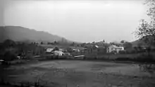
 Main Street (Old US 11W) in Bean Station | |
 Seal | |
| Nickname(s): | |
| Motto(s): "A Historical Crossroad" | |
 Location of Bean Station in Grainger and Hawkins counties in Tennessee | |
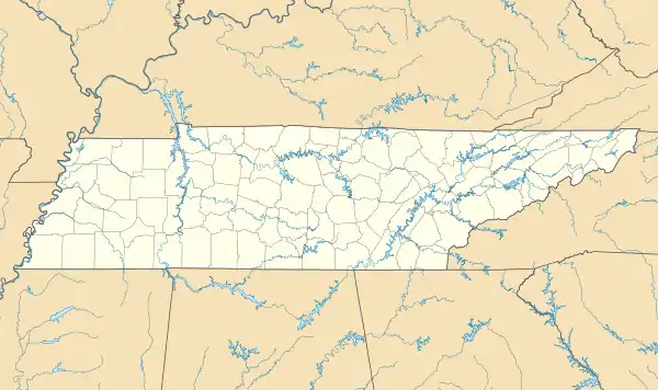 Bean Station Location of Bean Station in Grainger and Hawkins counties in Tennessee  Bean Station Bean Station (the United States) | |
| Coordinates: 36°20′37″N 83°17′03″W | |
| Country | United States |
| State | Tennessee |
| Counties | Grainger, Hawkins |
| Founded | 1776 |
| Incorporated | 1996 |
| Founded by | William Bean[3] |
| Named for | Bean family settlement[4] |
| Government | |
| • Type | Mayor-council |
| • Mayor | Ben Waller |
| • Vice Mayor | Jeff Atkins |
| • Town Council | Aldermen
|
| Area | |
| • Total | 5.99 sq mi (15.51 km2) |
| • Land | 5.99 sq mi (15.51 km2) |
| • Water | 0.00 sq mi (0.01 km2) |
| Elevation | 1,112 ft (339 m) |
| Population | |
| • Total | 2,826 |
| • Estimate (2019)[9] | 3,113 |
| • Density | 519.87/sq mi (200.72/km2) |
| Time zone | UTC-5 (Eastern (EST)) |
| • Summer (DST) | UTC-4 (EDT) |
| ZIP code | 37708, 37811 |
| Area codes | 865, 423 |
| GNIS feature ID | 2403829 |
| FIPS code | 47-03760 |
| Website | City of Bean Station at the Wayback Machine (archived December 30, 2005) |
Bean Station is located primarily at the junction of U.S. Route 11W and U.S. Route 25E, in the easternmost part of Grainger County. It is considered a popular lakeside community appealing to retirees and tourists, and a commuter town for the city of Morristown in neighboring Hamblen County.
It is part of both the Knoxville Metropolitan Statistical Area and the Morristown Metropolitan Statistical Area.[11]
History
.jpg.webp)
Early years and settlement
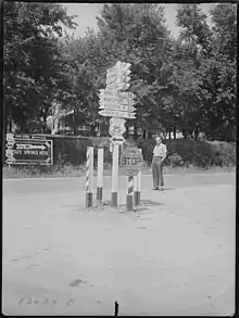
In 1775, pioneers Daniel Boone and William Bean had first observed what is now Bean Station after crossing the gap at Clinch Mountain during a long hunting excursion.[3] After fighting in the American Revolutionary War one year later, Bean was awarded 3,000 acres (12 km2) in the area he previously surveyed for settlement during his excursion with Boone.[3] Bean would later construtct a four-room cabin at this site, which served as his family's home, and as an inn for prospective settlers, fur traders, and longhunters.[12] This inn and its area would have many names: Bean's Cabin, Bean's Crossroads, and Bean's Station.[12] Bean Station would later grow into a frontier outpost established in the late 1780s by the sons of Bean. This outpost included the cabin that the Bean family resided in, a tavern, and a blacksmith's shop operated by Bean's sons.[3][12] The settlement was situated at the intersection of the Wilderness Road, a north–south pathway constructed in the 1780s that roughly followed what is present-day U.S. Route 25E, and the Great Indian Warpath, an east–west pathway that roughly followed what is now U.S. Route 11W.[13][14][15] This heavily trafficked crossroads location made Bean Station an important stopover for early American travelers, with taverns and inns were operating at the station by the early 1800s.[13]
Bean Station Tavern
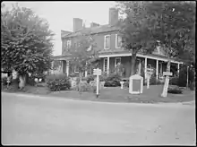
Through out the 1800s, Bean Station attracted the attention of numerous merchants and businessmen who appealed to the travelers that used the community's significant crossroads of the designated Wilderness Road and the East-West Road (Broadway of America) which replaced the Great Indian Warpath.[13][16] In 1825, Bean Station Tavern, with a 40-room capacity, wine cellar, and ballroom, was constructed at the crossroads. The tavern, was considered to be one of the largest of its time between New Orleans and Washington, D.C., and housed several famous guests including U.S. Presidents Andrew Jackson, Andrew Johnson, and James K. Polk.[13]
When the Tennessee Valley Authority announced the impounding of the Holston River and the site of Bean Station in the 1940s, efforts began to deconstruct and relocate the tavern to a new relocation site of the community.[17] Due to several components of the structure becoming lost, the effort to reconstruct the structure was cancelled.[17]
In 1961, the TVA had proposed plans to create a 50-acre historical park near the western interchange of US 11W and US 25E for a recreated version of the tavern. However, these plans were later scrapped.[18]
Battle of Bean’s Station and the Civil War
During the Civil War, the Battle of Bean's Station took place in the westernmost area of the community on December 14, 1863. Confederate Army General, James Longstreet, attempted to capture Bean Station en route to Rogersville after failing to drive Union forces out of Knoxville. Bean Station was held by a contingent of Union soldiers under the command of General James M. Shackelford. After two days of gruesome fighting, Union forces were forced to retreat.[13]
Tate Springs Resort
In the post-Civil War era, a businessman named Samuel Tate constructed a hotel just west of Bean Station that became the main focus of a resort known as Tate Springs.[19] Around the late 1870s, the property was purchased by Captain Thomas Tomlinson, who would transform the property into a vast resort, focused on a large Victorian-style luxury hotel, that advertised the supposed healing powers of its mineral spring’s water.[20] During its heyday, the resort complex included over three-dozen buildings, a 100-acre (40 ha) park, and an 18-hole golf course.[21] The resort had attracted some of the wealthiest people in America during this time.[19] The resort declined during the Great Depression.[22] The hotel was destroyed by fire in 1963, and the only remnants of the complex are the cabins of the site, the pool bathhouse, and the springhouse, the last of which was listed on the National Register of Historic Places in 1973.[22]
Peavine Railroad
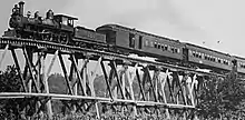
From the late 19th century until the early 20th century, Bean Station was a stop along the Knoxville and Bristol Railroad, commonly known by locals as the Peavine Railroad. The railroad was a branch line of the Southern Railway that ran from Morristown to Corryton, a bedroom community outside of Knoxville.[23] The Peavine Railroad had first operated between Morristown and Bean Station, with plans to connect north to the Cumberland Gap, but instead extended west through Grainger County towards Knoxville.[24] The Tate Springs resort located in west Bean Station, had its peak popularity between the 1890s and 1920s when the Peavine Railroad provided passenger rail connections to the site.[25]
Flooding and relocation
The construction of Cherokee Dam by the Tennessee Valley Authority (TVA) several miles downstream along the Holston River had plans that included impounding the site where the town was originally settled. Of the 195 to 200 families who lived at the original site of Bean Station,[26] 140 were mandated to move.[27]
Because of the historical significance, size and potential relocation problems presented with Bean Station, officials from the TVA, historians, and concerned community members gathered to discuss the future of the town and its relocation efforts in 1941.[28] A planning commission from the state government and TVA personnel developed plans for sites for Bean Station to relocate to. After controversy arose from negotiations from unwilling property owners and reluctance from citizens to relocate as a community, the planned community relocation project was abandoned, with the citizens relocating on their own will.[27] Many houses and other structures were demolished or moved, and at least one historical structure had to be relocated.[13]
Modern day
In 1967, a group of area residents organized and chartered the Bean Station Volunteer Fire Department.[1] Eight years later, the Bean Station Volunteer Rescue Squad was organized and chartered.[1]
Through the mid-20th century, Bean Station saw positive growth in population and economic progress as the community's two main transportation routes, U.S. Routes 11W and 25E were used prominently for the trucking industry, making the community a site of numerous truck stops.[29] However, after the completion of Interstate 81 south of Bean Station, the community saw a 60% decline in business.[29] As the region's economy began to diversify, manufacturing soon took over agriculture as the area's main source of income.[30]
In the early 1980s, US-25E/SR-32 was widened to a four-lane highway from Lakeshore Drive to a replacement bridge across Cherokee Lake into Morristown.[31]
In 1995, US-11W and US-25E were re-routed and widened into a four-lane divided-highway,[32] bypassing the then unincorporated area's central business district and prompting several businesses to relocate onto the new bypass.[30]
On May 23, 2013, an ex-police officer for the town shot four people in a pharmacy in downtown Bean Station, killing two. The following day, a vigil was held for the two victims with an estimated attendance of 300 individuals.[33]
1972 US-11W bus/semi-truck collision
On May 13, 1972, 14 people were killed and 15 injured in a head-on collision between a double-decker Greyhound bus and a tractor-trailer on U.S. Route 11W in Bean Station during its unincorporated era.[34][35] The accident is considered one of the deadliest and worst traffic collisions in the history of the state of Tennessee.[36][37] The accident led to outcry from politicians and citizens calling for traffic safety and infrastructure improvements, such as highway widenings, and the completion of Interstate 81 in Tennessee.[38]
Incorporation
As the population of the Bean Station region grew through-out the later 20th century, and the possibility of the community being annexed into the neighboring Morristown-Hamblen area,[30] residents gathered to incorporate Bean Station into a city. There were several attempts at incorporating the area that were never successful, the closest being in 1964 and 1977.[39][40][41] The last attempt would take place in 1994.[1] Bean Station was incorporated into a city of 2,171 residents by referendum election in 1996.[42][1][43] Before its incorporation into a city, Bean Station was represented as a census county division.[44]
Geography
Bean Station is located in rural easternmost Grainger County, 45 miles northeast of Knoxville,[45] where it borders the unincorporated community of Mooresburg at the line between Grainger and Hawkins counties. The town is situated in the Richland Valley (also known as Mooresburg Valley) with Clinch Mountain to the north and Cherokee Lake to the south. In the western of portion of Bean Station adjacent to Kingswood Home for Children on the Tate Springs resort site, two major highways merge, with U.S. Route 25E entering from the northwest, and U.S. Route 11W entering from the southwest. From this point, US-25E leads over Clinch Mountain 20 miles (32 km) to Tazewell in Claiborne County, while US-11W runs west through the Richland Valley 11 miles (18 km) to Rutledge, the seat of Grainger County. The highways split again just south of Bean Station's central business district, with 11W bypassing the business district and continining northeastward 17 miles (27 km) to Rogersville, and 25E continuing southward across Cherokee Lake into Hamblen County, 10 miles (16 km) to Morristown.
Tennessee State Route 375 (also known as Lakeshore Drive) also intersects US-25E south of the business district, which traverses into several of Bean Station’s affluent outskirt lakefront neighborhoods and subdivisions.
According to the U.S. Census Bureau, Bean Station has an area of 5.4 square miles (14.0 km2), of which 0.436 acres (1,763 m2), or 0.01%, are water.[8] The town limits include Wyatt Village, located next to an arm of Cherokee Lake along US-25E south of downtown, and portions of Tate Springs located near US-11W and Briar Fork Creek on Cherokee Lake. The town limits stretch 8 miles (13 km) along the heavily trafficked US-25E to the Olen R. Marshall Memorial Bridge across Cherokee Lake,[46] and 4 miles (6.4 km) along US-11W to Bean Station Elementary School.
Since 2014, portions of unincorporated Hawkins County in the Mooresburg area have been annexed into the town limits.[47]
Neighborhoods
- Bayside
- Campbell Heights
- Clinchview Landing
- Country Club Hills
- Crosby Park
- Gammon Springs
- Hillview Acres
- Lakeview Estates
- Leon Rock
- Livingston Heights
- Meadow Branch
- Meadow Creek Estates
- Shields Crossing
- Tanglewood
- Tate Springs
- Wyatt Village
Demographics
| Historical population | |||
|---|---|---|---|
| Census | Pop. | %± | |
| 2000 | 2,514 | — | |
| 2010 | 2,826 | 12.4% | |
| 2019 (est.) | 3,113 | [9] | 10.2% |
| Sources:[48] | |||
As of the 2010 United States Census, there were 2,826 people, 1,149 households, and 827 families residing in the town.
96.8% were White, 0.6% Black or African American, 0.5% Native American, 0.1% Asian and 0.7% of two or more races. 2.3% were Hispanic or Latino (of any race).
The average household size was 2.46 and the average family size was 2.88. 25% of households had children under the age of 18 living with them, 51.8% were married couples living together, 6.3% had a male householder with no wife present, and 13.9% were female householders with no husband present. 28% of households were non-families. The median age of residents in the town was 47.8. 21.7% of residents were under the age of 18, and 16.2% were age 65 years or older.
Economy
In its retail and commercial markets, Bean Station has a small selection of restaurants and stores. A large cluster of run-down firework stores are located through out the town due to Grainger County being among the few counties in Tennessee allowing the sale of fireworks.[2][49] A family-operated IGA Market is the only grocery store in Bean Station area.[50]
Bean Station is home to a furniture manufacturing facility,[51] a Clayton Homes manufacturing facility,[52] and a construction materials supplier.[53]
In 2010, 72% of the town’s population was reported to commute outside of Grainger County for work, with most finding employment in Morristown.[54] The average commute time for Bean Station residents is 24 minutes.[55]
Arts and culture
Since 1996, the town hosts an annual harvest festival in its downtown district celebrating the area's agricultural and craftsmanship scenes.[43] The festival attracts thousands of festival-goers and tourists alike every third weekend in October.[56][57] In 2007, the town made national headlines after breaking a Guinness World Record for the world's largest pot of beans at the 11th annual Harvest Pride festival, with the pot holding 600 gallons of baked beans.[56][58][59]
Historic sites
- Battle of Bean's Station site[60]
- Original Bean Station settlement site, Bean cabin site, and historical marker[61]
- Tate Springs resort site and Tate Springs Springhouse[1]
Parks and recreation
The town is considered popular with boaters and anglers alike due to its access to Cherokee Lake.[43] Clinch Mountain, located north of the town, provides the opportunity for hiking.[43] A public golf course is also located within the town limits.[43]
Parks and public recreation areas include:
Government
Bean Station uses the mayor-aldermen system, which was established in 1996 when the town was incorporated. It is governed locally by a five-member Board of Mayor and Aldermen. The citizens elect the mayor and four aldermen to four-year terms. The board elects a vice mayor from among the four aldermen.[65]
Bean Station is represented in the 35th District of the Tennessee House of Representatives by Jerry Sexton, a Republican.[66]
It is represented in the 8th District of the Tennessee Senate by Frank Niceley, also a Republican.[67]
Bean Station is represented in the United States House of Representatives by Republican Tim Burchett of the 2nd congressional district.[68]
Education
Bean Station Elementary School, located at the westernmost part of the town, is operated by the Grainger County Department of Education. Elementary students attend Bean Station Elementary, middle school students attend Rutledge Middle, and high school students attend Grainger High School in Rutledge, along with other students in the Grainger County Schools District, excluding the Washburn area.[69]
Kingswood Home for Children, located in the Tate Springs area of Bean Station, operates as a children’s home.[70]
Media
Newspaper
- Grainger Today
In film
The 1981 horror film, The Evil Dead, had filmed a part of its opening scene in the northern Grainger County, and in Bean Station along Old U.S. Route 25E near Bean Station Elementary School.[71]
Infrastructure
Utilities
Bean Station Utility District, (BSUD), a municipal utilities company, connects the town and portions of eastern Grainger County with municipal water services.[72]
Appalachian Electric Cooperative (AEC), a utilities company based out of New Market in neighboring Jefferson County, provides electricity and the option for fiber broadband internet for all of Bean Station, portions of Hamblen County (including portions of Morristown), Jefferson County (including New Market, Baneberry, Jefferson City, Dandridge, and White Pine), and eastern Grainger County (including Rutledge).[73][74] AEC, as of June 2018, provides services to 46,000 customers.[74]
Sewer
Bean Station, as of 2019, does not have access to public sewer.[75] Since the town's incorporation, officials have expressed interest and have proposed several unsuccessful attempts towards constructing a sewage treatment system.[43][76] In 2019, a master plan conducted by a Knoxville based engineering firm found that there was a definite need for public sewer service in Bean Station, as many existing septic tank and drain field systems in the town have reported failures posing health hazards to residents, and development opportunities providing job and economic growth are limited with the lack of access to public sewer.[75]
In January 2021, proposals for a sewer line extension by Morristown Utilities System into south Bean Station were approved by the town council.[77]
Transportation
All U.S. routes and state routes in Bean Station are maintained by the Tennessee Department of Transportation (TDOT) in TDOT Region 1, which consists of 24 counties in the East Tennessee region.[78] Streets in the town are maintained by the Bean Station Street Department.[79]
Principal highways
 US 11W (Lee Highway)
 US 25E (East Tennessee Crossing Byway, Appalachian Development Corridor S)
 SR 1 (Concurrent to US 11W)
 SR 32 (Concurrent to US 25E)
 SR 375 (Lakeshore Drive)
Notable people
- Peter Ellis Bean - filibuster[82]
- William Bean - longhunter, namesake, and town founder[3]
- Jimmy Duncan - U.S. House Representative[83]
- Robert E. Preston - Director of United States Mint[84]
- William Tandy Senter - U.S. House Representative[85]
- Jerry Sexton - politician[86]
- John K. Shields - United States Senator[13]
In popular culture
Bean Station was referenced on the NBC police procedural comedy series Brooklyn Nine-Nine, as one of the secondary characters on the show, Bill Hummertrout, cited it as his hometown.[87]
References
| Wikimedia Commons has media related to Bean Station, Tennessee. |
- Grainger County Heritage Book Committee (January 1, 1998). Grainger County, Tennessee and Its People 1796-1998. Walsworth Publishing. Retrieved August 7, 2020.
- Rankin, Joe (June 30, 1977). "Business Booming Again in Grainger". Kingsport Times-News. p. 1, 10. Retrieved October 29, 2020 – via Newspapers.com.
- Coffey, Ken (October 19, 2012). "The First Family of Tennessee". Grainger County Historic Society. Thomas Daugherty. Retrieved August 20, 2020.
- Miller, Larry (2001). Tennessee Place Names. Indiana University Press. p. 14. ISBN 0-253-33984-7. Retrieved June 25, 2020 – via Google Books.
- University of Tennessee, Municipal Technical Advisory Service. "Bean Station". MTAS.tennessee.edu. Retrieved June 22, 2020.
- "2019 U.S. Gazetteer Files". United States Census Bureau. Retrieved July 30, 2020.
- "City of Bean Station". Geographic Names Information System. United States Geological Survey. Retrieved September 12, 2020.
- "Geographic Identifiers: 2010 Demographic Profile Data (G001): Bean Station city, Tennessee". American Factfinder. U.S. Census Bureau. Retrieved February 17, 2017.
- "Population and Housing Unit Estimates". United States Census Bureau. May 24, 2020. Retrieved May 27, 2020.
- Bobo, Jeff (February 5, 2020). "2020 a big year for Hawkins BOE, municipal elections". Kingsport Times-News. Retrieved July 27, 2020.
In Bean Station, which has a small section in Hawkins County, the alderman seats held by Patsy Harrell and Jeff Atkins are up for re-election.
- "Revised Delineations of Metropolitan Statistical Areas, Micropolitan Statistical Areas, and Combined Statistical Areas, and Guidance on Uses of the Delineations of These Areas" (PDF). Office of Management and Budget. Retrieved April 27, 2014.
- Barksdale, Kevin (July 11, 2014). The Lost State of Franklin: America's First Secession (E-book). University Press of Kentucky. p. 19. ISBN 9780813150093. Retrieved December 3, 2020.
- Coffey, Ken. "History of Bean Station". Town of Bean Station. Archived from the original on July 24, 2015. Retrieved July 23, 2015.
- Brown, Fred (2005). Marking Time (Paperback). University of Tennessee Press. pp. 99–101. ISBN 9781572333307. Retrieved October 17, 2020.
- Lane, Ida M. (December 1, 1929). "Once The Teeming Crossroads Of The Wilderness, Bean Station Now Lapsed Into Village Peace". Knoxville News Sentinel. p. 23. Retrieved November 7, 2020 – via Newspapers.com.
- Ball, Randy; Wolfe, Terry (November 19, 2013). Tate Springs 1898: Town of Bean Station, Tennessee. Town of Bean Station. p. 4. Retrieved January 20, 2021.
- Howes, Robert (January 1, 1944). The Bean Station Tavern Restoration Project. Knoxville: Tennessee Valley Authority, Department of Regional Studies. Retrieved August 20, 2020.
- "Restore Bean Station Tavern, Create Park, Morristown Asks". Knoxville News Sentinel. March 19, 1961. p. 4. Retrieved October 29, 2020 – via Newspapers.com.
- Seitz, Robert. "Tate Springs Resort and Hotel 1865-1941". Kingswood School History. Archived from the original on March 27, 2015. Retrieved December 21, 2020.
- Phillips, Bud (July 18, 2010). "Tate Springs was once a popular health resort". Bristol Herald Courier. Retrieved July 2, 2020.
- "Spring Histories". Tennessee State Library and Archives. Retrieved July 2, 2020.
- Beasley, Ellen (January 8, 1973). "NATIONAL REGISTER OF HISTORIC PLACES INVENTORY - NOMINATION FORM". National Register of Historic Places. National Park Service. Retrieved December 21, 2020.
- Faulkner, Charles (1985). "Industrial Archaeology of the "Peavine Railroad": An Archaeological and Historical Study of an Abandoned Railroad in East Tennessee". Tennessee Historical Quarterly. Tennessee Historical Society. 44 (1): 40–58. JSTOR 42626500.
- Hill, Howard (January 20, 1957). "The Old Peavine Railroad". Morristown Daily Gazette and Mail. p. 6. Retrieved August 7, 2020 – via Newspapers.com.
- West, Carroll Van (1995). Tennessee's Historic Landscapes: A Traveler's Guide. University of Tennessee Press. pp. 166–167. ISBN 9780870498817 – via Google Books.
- Coffey, Ken (May 20, 2018). "Lost by water: Bean Station History". Grainger Today. Archived from the original on July 24, 2018. Retrieved January 20, 2021.
- Tennessee Valley Authority (1946). The Cherokee Project: A Comprehensive Report on the Planning, Design, Construction, and Initial Operations of the Cherokee Project. Washington D.C.: United States Government Printing Office. pp. 32, 249 – via Google Books.
- Caruthers, Amelia (April 26, 1942). "Cherokee Lake Will Flood Site of East Tennessee Shrine, But Bean Tavern is 'Packed Away,' All Ready To Be Rebuilt". Knoxville News Sentinel. p. 26. Retrieved November 7, 2020 – via Newspapers.com.
- Rankin, Joe (July 17, 1977). "They're Waiting For The Trucks". Kingsport Times-News. p. 1, 10. Retrieved October 29, 2020 – via Newspapers.com.
- "A Brief History of Bean Station". City of Bean Station. Archived from the original on February 4, 2005. Retrieved August 7, 2020.
- SR-32, US-25E, Appalachian Corridor S, Grainger County: Environmental Impact Statement, Volume 2. Tennessee Department of Transportation. Federal Highway Administration. 1981 – via Google Books.CS1 maint: others (link)
- SR-32, US-25E, Appalachian Corridor S, Grainger County Environmental Impact Statement. Washington, D.C.: Federal Highway Administration. 1981. Retrieved January 1, 2021.
- Coleman, Lance (May 24, 2013). "Police: Bean Station pharmacy victims shot execution-style". The Knoxville News Sentinel. Retrieved June 7, 2020.
- "14 Die in Tennessee Bus Truck Crash". The New York Times. May 14, 1972. Retrieved May 6, 2020.
- Wolfe, Tracey (June 24, 2020). "Victim reunites with rescue workers 48 years after deadly crash". Grainger Today. Retrieved June 25, 2020.
- Lakin, Matt (August 26, 2012). "Blood on the asphalt: 11W wreck left 14 people dead". Knoxville News Sentinel. Retrieved May 6, 2020.
- Ahillen, Steve (October 3, 2013). "Jefferson wreck echoes Tennessee's most deadly bus accident". Knoxville News Sentinel. Retrieved July 14, 2020.
- Smith, Bob (May 14, 1972). "11-W Disaster Brings New Highway Pleas". Kingsport Times-News. p. 1, 10 – via Newspapers.com.
- "Voters Reject Incorporation". The Knoxville Journal. June 11, 1964. p. 13. Retrieved October 29, 2020.
- "Hawkins elections underway". Kingsport Times-News. September 7, 1977. Retrieved October 29, 2020.
- "Bean Station Plan Fails". Kingsport Times-News. September 19, 1977. p. 8. Retrieved October 19, 2020 – via Newspapers.com.
- "Petition for incorporation election for the City of Bean Station - Tennessee". Municipal Technology Advisory Service. 1996. Retrieved July 29, 2020.
- "About Bean Station". City of Bean Station. Archived from the original on February 4, 2005. Retrieved August 7, 2020.
- "Bean Station Division". Geographic Names Information System. United States Geological Survey. August 1, 1991. Retrieved September 13, 2020.
- "Locatior Map". City of Bean Station. Archived from the original on February 4, 2005. Retrieved December 13, 2020.
- Jacobs, Dan (May 23, 2010). "Murder Mysteries: Bean Station slaying still unsolved". Knoxville News Sentinel. Retrieved December 3, 2020.
- Bobo, Jeff (August 27, 2013). "Bean Station will seek referendum to annex Hawkins plant". Kingsport Times-News. Retrieved December 10, 2020.
- "Census of Population and Housing: Decennial Censuses". United States Census Bureau. Retrieved March 4, 2012.
- "Bean Station, TN to Tazewell, TN". Walk Over States.
- "Holt's Food Center IGA". holtsfoodcenter.iga.com/. Retrieved June 26, 2020.
- "Sexton Furniture Manufacturing LLC". Bloomberg. Retrieved June 26, 2020.
- "Norris Homes by Clayton Homes". Norris Homes. Retrieved May 8, 2020.
- Vulcan Materials. "Facilties". vulcanmaterials.com. Retrieved June 7, 2020.
- East Tennessee Development District (April 1, 2012). "Grainger County 2010 Census Report" (PDF). ETDD.org. Retrieved May 8, 2020.
- "Bean Station, TN". DataUSA.io. Retrieved May 18, 2020.
- Cason, Steve. "City to cook the world's largest pot of beans" (PDF). City of Bean Station. Archived from the original (PDF) on May 9, 2008. Retrieved August 9, 2020.
- Littleton, Wade (October 19, 2019). "Harvest Pride Festival attracts hundreds". The Citizen Tribune. Retrieved June 17, 2020.
- Branston, John (September 7, 2007). "Tennessee City Gassed Over World Record Pot of Beans". The Memphis Flyer. Retrieved July 12, 2020.
- "Bean festival scores an appropriate sponsor". AdWeek. October 23, 2007. Retrieved July 12, 2020.
- Morfe, Don (October 20, 2013). "Battle of Bean's Station". The Historical Marker Database. Retrieved December 28, 2020.
- Morfe, Don (October 20, 2013). "Bean Station". The Historical Marker Database. Retrieved December 28, 2020.
- "Cherokee Reservoir". Tennessee Valley Authority. Retrieved July 14, 2020.
- "Boating Ramps and Access". Tennessee Wildlife Resources Agency. Retrieved July 14, 2020.
- "Lakeside Marina". lakeside-marina.com. Retrieved July 1, 2020.
- "City Government". City of Bean Station. Archived from the original on April 22, 2011.
- "Representative Jerry Sexton". capitol.tn.gov. Retrieved June 25, 2020.
- "Senator Frank S. Niceley". capitol.tn.gov. Retrieved June 25, 2020.
- "Our District". Congressman Tim Burchett. Retrieved June 25, 2020.
- "Schools". Grainger County Schools. Retrieved July 3, 2020.
- Lakins, Laura (October 14, 2020). "Kingswood Home for Children receives sidewalk and gazebo". Grainger Today. Retrieved October 17, 2020.
- "Locations". bookofthedead.ws. Retrieved July 12, 2020.
- "Business & Industry". Grainger County, Tennessee. Archived from the original on January 15, 2006. Retrieved September 8, 2020.
- "Outage Map". Appalachian Electric Cooperative. Retrieved August 8, 2020.
- "Facts About Your Cooperative" (PDF). Appalachian Electric Cooperative. June 30, 2018. Retrieved August 8, 2020.
- Fulghum Macindoe & Associates Inc. (March 12, 2019). "Bean Station, Tennessee Wastewater Treatment Master Plan" (PDF). Tennessee Department of Environment and Conservation. Retrieved August 10, 2020.
- Littleton, Wade (March 13, 2019). "Bean Station officials talk sewer at special-called meeting". Citizen Tribune. Retrieved September 13, 2020.
- Wolfe, Tracey (January 27, 2021). "Atkins re-elected vice mayor". Grainger Today. Retrieved January 27, 2021.
- "Find Information". Tennessee Department of Transportation. Retrieved July 22, 2020.
- "Street Department". Town of Bean Station. Archived from the original on February 21, 2014. Retrieved September 8, 2020.
- "Bean Station North" (PDF). Tennessee Department of Transportation. Federal Highway Administration. 2004. Retrieved September 8, 2020.
- "Bean Station South" (PDF). Tennessee Department of Transportation. Federal Highway Administration. 2004. Retrieved September 8, 2020.
- Weems, John Edward. "Bean, Peter Ellis". Handbook of Texas Online. Retrieved July 30, 2020.
- Vines, Georgiana (October 21, 2018). "Outgoing Congressman John J. 'Jimmy' Duncan reflects on 30 years in office". Knoxville News Sentinel. Retrieved June 22, 2020.
- Current History and Modern Culture: 1893. 3. Current History Company. 1894. p. 499 – via Google Books.
- Biographical Directory of the American Congress 1774-1971. U.S. Government. 1971. p. 1677 – via Google Books.
- "TN House Passes Bill for Monument to Unborn". WJHL. April 21, 2018.
- Payne, Alex (June 6, 2020). "Brooklyn Nine-Nine's Secondary Characters, Ranked". CBR. Retrieved September 7, 2020.
External links
Municipalities and communities of Grainger County, Tennessee, United States | ||
|---|---|---|
| Cities | ||
| Town | ||
| Unincorporated communities | ||
| Footnotes | ‡This populated place also has portions in an adjacent county or counties | |
| ||
Municipalities and communities of Hawkins County, Tennessee, United States | ||
|---|---|---|
| Cities | Hawkins County, Tennessee | |
| Towns | ||
| CDP | ||
| Unincorporated communities | ||
| Ghost town | ||
| Footnotes | ‡This populated place also has portions in an adjacent county or counties | |
| ||
| Principal City |   | |
|---|---|---|
| Other Cities | ||
| Counties | ||
| Principal City | 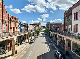  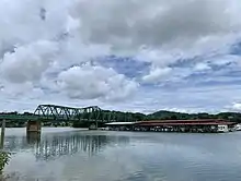 | |
|---|---|---|
| Other Cities | ||
| Counties | ||