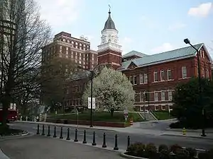
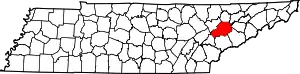
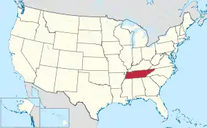
Knox County, Tennessee
Knox County is located in the U.S. state of Tennessee. As of the 2010 census, the population was 432,226,[2] making it the third-most populous county in Tennessee. It ranks as the 153rd-most populous county or county-equivalent in the nation. Its county seat is Knoxville,[3] which is the third-most populous city in Tennessee.
Knox County | |
|---|---|
| County of Knox | |
 | |
 Seal | |
 Location within the U.S. state of Tennessee | |
 Tennessee's location within the U.S. | |
| Coordinates: 35°59′N 83°56′W | |
| Country | |
| State | |
| Founded | June 11, 1792 |
| Named for | Henry Knox[1] |
| Seat | Knoxville |
| Largest city | Knoxville |
| Government | |
| • Mayor | Glenn Jacobs (R) |
| Area | |
| • Total | 526 sq mi (1,360 km2) |
| • Land | 508 sq mi (1,320 km2) |
| • Water | 18 sq mi (50 km2) 3.5%% |
| Population | |
| • Estimate (2019) | 470,313 |
| • Density | 850/sq mi (330/km2) |
| Congressional district | 2nd |
| Website | knoxcounty |
Knox County is included in the Knoxville metropolitan area. The county is located at the geographical center of the Great Valley of East Tennessee. Near the heart of the county is the origin of the Tennessee River, at the confluence of the Holston and French Broad rivers.
History
Knox County was created after the American Revolutionary War on June 11, 1792, by Governor William Blount from parts of Greene and Hawkins counties. It was one of the few counties created when this area was still known as the Southwest Territory.[1] It is one of nine United States counties named for American Revolutionary War general Henry Knox, who was appointed as the first United States Secretary of War.[4] As population increased, parts of Knox County were taken out to form Blount (1795), Anderson (1801), Roane (1801), and Union (1850) counties.
In 1783, James White and Francis Alexander Ramsey led an expedition to explore the Upper Tennessee Valley, now within the boundaries of Knox County. White moved to what is now the Riverdale community in the eastern part of the county in 1785, and the following year constructed a fort a few miles to the west. A community developed around the fortified trading post, ultimately becoming the city of Knoxville. Governor Blount designated the fort as the capital of the Southwest Territory in 1790, and gave the new town the name "Knoxville" after his superior, Henry Knox.[5]
Blount began construction of his house, Blount Mansion, in the early 1790s. This is one of a number of late eighteenth-century structures that have been preserved in the county. The house still stands in downtown Knoxville. The Alexander McMillan House, built in the mid-1780s by Alexander McMillan (1749–1837), still stands in eastern Knox County. The Alexander Bishop House, built by Stockley Donelson in 1793,[6] and a log house built in the same year by Nicholas Gibbs, both still stand in the northern part of the county.[7] Campbell's Station, a fort and stagecoach stop located in what is now Farragut, was built by Captain David Campbell (1753–1832) in 1787.[8] John Sevier established a plantation, known as Marble Springs, in the southern part of the county in the 1790s.[9] He was active in leading raids against the Cherokee people, who for years resisted with force American settlement in their territory.
Civil War
Important railroad lines passed through Knox County, making it a strategic area to control by both Union and Confederate forces throughout the Civil War. Since the mountainous terrain of East Tennessee was mostly unsuitable for plantation crops such as cotton, slavery was not as prevalent as it was in Middle and West Tennessee. The US 1860 census of Knox County showed a population of 20,020 white citizens and 2,370 enslaved African Americans.[10] The lack of slavery combined with the vestiges of a once strong abolitionist movement in the region were two of the reasons that most residents of Knox County, along with much of East Tennessee, were pro-Union. In February 1861, 89% of Knox Countians voted for the pro-Union ballot in a statewide referendum on secession. On June 8, 1861, the county voted against Tennessee's Ordinance of Secession by a margin of 3,108 to 1,226.[11]
Prior to secession, Unionists from Knox County collaborated with other East Tennessee Unionists in an attempt to secede from Tennessee itself and remain part of the Union. Oliver Perry Temple, a Knoxville lawyer, was named to a 3-man commission to appear before the General Assembly in Nashville and request East Tennessee and pro-Union Middle Tennessee counties be allowed to secede from the state.[12] The attempt failed. After the second state referendum for secession passed in 1861, Knox County and the rest of Tennessee joined the Confederacy.[13]
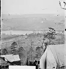
Knox County remained under Confederate control until September 3, 1863, when General Ambrose Burnside and the Union army marched into Knoxville unopposed. Parts of Middle Tennessee had been occupied by Union troops since 1862.
Union Colonel William Harris, son of New York Senator Ira Harris, wrote his father:[10]
'Glory be to God, the Yankees have come! The flag's come back to Tennessee!' Such were the welcomes all along the road, as we entered Knoxville, it was past all description. The people seemed frantic with joy. I never knew what the Love of Liberty was before. The old flag has been hidden in mattresses and under carpets. It now floats to the breeze at every staff in East Tennessee. Ladies wear it -- carry it -- wave it! Little children clap their hands and kiss it.
With the success of Burnside's troops in the Knoxville Campaign, and especially during the decisive Battle of Fort Sanders, Knox County remained under Union control for the duration of the Civil War.
Tennessee marble
In the late 19th and early 20th centuries, Knox County was an important venue for the quarrying and finishing of Tennessee marble, a type of limestone used in monument construction across the United States and Canada. Eleven quarries were operating in Knox County in 1882, and within ten years that number had doubled. Notable quarries in Knox included the Bond Quarry in Concord, an Evans Company quarry near Forks-of-the-River, and the Ross-Republic quarries near Island Home Park in South Knoxville. Finishing centers were located in Lonsdale and at the Candoro Marble Works in South Knoxville.[14][15]
Geography

According to the U.S. Census Bureau, the county has a total area of 526 square miles (1,360 km2), of which 508 square miles (1,320 km2) is land and 18 square miles (47 km2) (3.4%) is water.[16] The county lies amidst the Ridge-and-Valley Appalachians, which are characterized by long, narrow ridges, oriented northeast-to-southwest, alternating with similarly shaped valleys. Notable ridges in the county include Bays Mountain, McAnnally Ridge, Beaver Ridge, Sharp's Ridge and Copper Ridge. House Mountain, at 2,064 feet (629 m), is the county's highest point, and is the focus of a state natural area.[17]
The Holston and French Broad rivers join to form the Tennessee River in the eastern part of the county, an area known as "Forks-of-the-River." This section of the river is part of Fort Loudoun Lake, which is created by Fort Loudoun Dam on the river several miles downstream in Lenoir City.
Cherokee Caverns
Cherokee Caverns is 14 miles west of Knoxville and can be accessed by Highway 62. It was discovered in 1854 by Robert Crudgington, who noticed fog emerging between rocks on his farm. He dug the entrance open and explored the cave. His daughter Margaret Crudgington opened the cave to the public in 1929 under the name Gentrys Cave; the next year she changed the name to Grand Caverns.
The cave has been open to the public, sporadically, ever since, under a variety of names. It is currently called Cherokee Caverns, referring to the historic tribe that occupied this area at the time of European encounter.[18]
Indian artifacts located in the cave indicate that another entrance to the cave existed at some time in the past.[18]
Adjacent counties
- Union County (north)
- Grainger County (northeast)
- Jefferson County (east)
- Sevier County (southeast)
- Blount County (south)
- Loudon County (southwest)
- Roane County (west)
- Anderson County (northwest)
State protected areas
- Forks of the River Wildlife Management Area
- Fort Loudoun Wildlife Management Area
- House Mountain State Natural Area
- Marble Springs (state historic site)
- Seven Islands State Birding Park
Demographics
| Historical population | |||
|---|---|---|---|
| Census | Pop. | %± | |
| 1800 | 12,446 | — | |
| 1810 | 10,171 | −18.3% | |
| 1820 | 13,034 | 28.1% | |
| 1830 | 14,498 | 11.2% | |
| 1840 | 15,485 | 6.8% | |
| 1850 | 18,807 | 21.5% | |
| 1860 | 22,813 | 21.3% | |
| 1870 | 28,990 | 27.1% | |
| 1880 | 39,124 | 35.0% | |
| 1890 | 59,557 | 52.2% | |
| 1900 | 74,302 | 24.8% | |
| 1910 | 94,187 | 26.8% | |
| 1920 | 112,926 | 19.9% | |
| 1930 | 155,902 | 38.1% | |
| 1940 | 178,468 | 14.5% | |
| 1950 | 223,007 | 25.0% | |
| 1960 | 250,523 | 12.3% | |
| 1970 | 276,293 | 10.3% | |
| 1980 | 319,694 | 15.7% | |
| 1990 | 335,749 | 5.0% | |
| 2000 | 382,032 | 13.8% | |
| 2010 | 432,226 | 13.1% | |
| 2019 (est.) | 470,313 | [19] | 8.8% |
| U.S. Decennial Census[20] 1790-1960[21] 1900-1990[22] 1990-2000[23] 2010-2014[2] | |||
2000 census
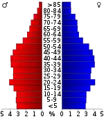
As of the census[25] of 2000, there were 382,032 people, 157,872 households, and 100,722 families residing in the county. The population density was 751 people per square mile (290/km2). There were 171,439 housing units at an average density of 337 per square mile (130/km2). The racial makeup of the county was 88.10% White, 8.63% Black or African American, 0.26% Native American, 1.29% Asian, 0.03% Pacific Islander, 0.50% from other races, and 1.18% from two or more races. 1.26% of the population were Hispanic or Latino of any race.
There were 157,872 households, out of which 28.50% had children under the age of 18 living with them, 49.80% were married couples living together, 10.90% had a female householder with no husband present, and 36.20% were non-families. 29.60% of all households were made up of individuals, and 9.10% had someone living alone who was 65 years of age or older. The average household size was 2.34 and the average family size was 2.92.
In the county, the population was spread out, with 22.30% under the age of 18, 11.60% from 18 to 24, 30.40% from 25 to 44, 23.10% from 45 to 64, and 12.70% who were 65 years of age or older. The median age was 36 years. For every 100 females, there were 93.50 males. For every 100 females age 18 and over, there were 90.10 males.
The median income for a household in the county was $37,454, and the median income for a family was $49,182. Males had a median income of $35,755 versus $25,140 for females. The per capita income for the county was $21,875. About 8.40% of families and 12.60% of the population were below the poverty line, including 14.50% of those under age 18 and 9.70% of those age 65 or over.
2010 census
As of the census[25] of 2010, there were 432,226 people, 177,249 households, and 110,757 families residing in the county. The population density was 821.72 persons per square mile. The average housing unit density was 348.92 units per square mile. The racial makeup of the county was 86.78% White, 8.8% Black or African American, 0.29% Native American, 1.87% Asian, 0.08% Pacific Islander, and 1.91% multiracial. Hispanics and/or Latinos (of any race) were 3.47% of the population.
Out of all of the households, 29.68% had children under the age of 18 living in them, 47.04% were family households, 3.95% had a male householder with no wife present, 11.49% had a female householder with no husband present, and 37.51% were non families. 29.65% of all households were made up of individuals living alone, and 9.14% had someone living alone who was 65 years of age or older. The average household size was 2.37 and the average family size was 2.95.
21.86% of the population was under the age of 18, 65.07% from ages 18 to 64, and 13.05% aged 65 and older. The median age was 37.2 years. 51.39% of the population was female, and 48.61% was male.
The median household income was estimated to be $52,458, and the per capita income was estimated to be $30,541. Approximately 13.5% of the population was below the poverty line.
Government and politics
Like most counties in heavily Unionist East Tennessee, Knox County has historically been strongly Republican. Although it is somewhat conservative for an urban county, it is slightly less Republican than the rest of East Tennessee. Presidentially, Franklin Roosevelt carried the county in three of his four presidential bids, while neighboring Blount, Sevier and Grainger counties are among the only counties in the nation to have never supported a Democratic candidate for president in their entire existence. Nevertheless, Democratic candidates have only crossed the 40 percent mark seven times since Roosevelt's death. In 1964, it was nearly swept up in Lyndon Johnson's national landslide; LBJ only lost the county by 330 votes. Jimmy Carter in 1976 and Bill Clinton in 1992 and 1996 are the only Democrats since then to come reasonably close to carrying the county, losing it by single-digit margins; in Clinton's case with Tennesseean Al Gore on the ticket. Gore lost the county by 17 points in 2000 during his own bid for president, but still managed 40 percent. The Democrats would not cross the 40 perce and another was in the Democratic landslide of 1964. In 2020, Joe Biden won 41 percent of the county's vote, the best showing for a Democrat in the county since Clinton.
| Year | Republican | Democratic | Third Parties |
|---|---|---|---|
| 2020 | 56.5% 124,540 | 41.5% 91,422 | 2.0% 4,594 |
| 2016 | 58.5% 105,767 | 34.8% 62,878 | 6.7% 12,052 |
| 2012 | 63.6% 109,707 | 34.4% 59,399 | 2.0% 3,401 |
| 2008 | 60.7% 113,015 | 37.7% 70,215 | 1.5% 2,856 |
| 2004 | 62.1% 110,803 | 37.0% 66,013 | 0.9% 1,603 |
| 2000 | 57.7% 86,851 | 40.5% 60,969 | 1.8% 2,766 |
| 1996 | 50.5% 70,761 | 43.7% 61,158 | 5.8% 8,126 |
| 1992 | 46.8% 66,607 | 41.9% 59,702 | 11.4% 16,167 |
| 1988 | 63.3% 73,092 | 36.2% 41,829 | 0.5% 600 |
| 1984 | 63.6% 76,965 | 35.9% 43,448 | 0.5% 574 |
| 1980 | 56.3% 66,153 | 38.8% 45,634 | 4.9% 5,798 |
| 1976 | 50.7% 56,013 | 48.0% 53,034 | 1.2% 1,362 |
| 1972 | 71.6% 64,747 | 26.6% 24,076 | 1.8% 1,661 |
| 1968 | 52.4% 47,202 | 27.3% 24,528 | 20.3% 18,277 |
| 1964 | 50.2% 42,797 | 49.8% 42,463 | |
| 1960 | 61.0% 50,811 | 38.4% 31,990 | 0.6% 499 |
| 1956 | 60.1% 46,167 | 38.7% 29,768 | 1.2% 896 |
| 1952 | 62.3% 44,358 | 37.5% 26,681 | 0.2% 139 |
| 1948 | 53.8% 21,074 | 40.7% 15,946 | 5.6% 2,176 |
| 1944 | 52.6% 20,742 | 46.9% 18,482 | 0.6% 228 |
| 1940 | 40.5% 13,877 | 59.0% 20,226 | 0.6% 201 |
| 1936 | 37.9% 12,183 | 61.8% 19,837 | 0.3% 100 |
| 1932 | 46.7% 9,774 | 51.4% 10,755 | 1.9% 398 |
| 1928 | 71.6% 14,627 | 28.2% 5,767 | 0.2% 49 |
| 1924 | 56.4% 10,709 | 36.5% 6,935 | 7.1% 1,340 |
| 1920 | 63.4% 12,005 | 35.9% 6,801 | 0.7% 125 |
| 1916 | 57.3% 5,791 | 41.7% 4,214 | 1.1% 106 |
| 1912 | 19.9% 1,984 | 40.7% 4,069 | 39.4% 3,938 |
| 1908 | 56.5% 5,817 | 39.7% 4,090 | 3.6% 378 |
| 1904 | 55.6% 4,309 | 41.2% 3,196 | 3.1% 243 |
| 1900 | 46.3% 3,982 | 51.0% 4,389 | 2.5% 221 |
| 1896 | 59.8% 6,243 | 38.5% 4,020 | 1.6% 172 |
| 1892 | 49.1% 4,182 | 46.8% 3,987 | 4.0% 347 |
| 1888 | 59.1% 6,123 | 37.9% 3,929 | 2.9% 305 |
| 1884 | 59.1% 5,248 | 39.2% 3,481 | 1.6% 149 |
| 1880 | 58.1% 4,361 | 41.6% 3,119 | 0.2% 16 |
The government of Knox County, Tennessee operates under a home rule format. The county administrator, formerly known as the County Executive, is called the County Mayor. There is also an elected county commission, which consists of 11 members. Knox County is divided into nine commission districts, with one commissioner elected from each district. Two commissioners are elected countywide and serve as at-large representatives. The county commissioners' districts do not correspond with those of the city of Knoxville, which has its own mayor and city council. Residents of the county living within Knoxville city limits vote in both city and county elections, are represented by city and county mayors, and pay city and county taxes. While the administration appears to be duplicated, services tend to be separated. Knox County runs the local school and library systems. Knoxville maintains a police department independent of the county sheriff. The property assessor's office, tax offices, and the Metropolitan Planning Commission are combined between the city and county governments. All Knox County elections are conducted on a partisan basis.[27]
Executive Branch
The county mayor is the head of the executive branch of Knox County Government. The current county mayor is Glenn Jacobs, better known by his WWE identity of Kane. According to the county's charter, the mayor is the chief financial officer of the county, which includes developing the county's annual budget, approving county contracts, etc. Other responsibilities of the county mayor's office include maintaining county roads, highways and bridges, codes enforcement and operating the county's health department and library system.[27]
The mayor has the authority to veto resolutions and ordinances passed by the Knox County Commission. A majority-plus-one vote is required to override a mayoral veto, unless the vetoed legislation was required to have a two-thirds vote for original passage. In such cases, a two-thirds vote of the commission is required to override the veto.[27]
Executive Branch Departments
- Finance
- Purchasing
- Community Development
- Engineering & Public Works
- Highway Engineering
- Highway Maintenance
- Stormwater Management
- Codes Enforcement
- Solid Waste & Recycling
- Fire Prevention Bureau
- Probation
- Risk Management & Human Resources
- Veterans Services
- Senior Services
- Health Department
- Air Quality
- Knox County Public Library
- Constituent Services
- Communications
- Information Technology
Legislative Branch
The Knox County Board of Commissioners is the legislative body of Knox County and consists of 11 members: nine elected at the district level and two elected countywide to serve at-large.[28] Commissioners meet multiple times each month, with their primary business meetings being a monthly work session and a monthly voting meeting. During the work session, commissioners generally debate items on the monthly agenda and take a non-binding vote on each item in advance of the more formal voting meeting, which is generally held the following week.[27]
The Board of Commissioners approves resolutions, ordinances, honorariums, road names, as well as most county contracts and large expenditures. Resolutions require a single vote for passage, while ordinances require two votes, or "two readings". The County Commission also serves as the appropriating body of the county and must approve an annual budget—presented by the mayor—which includes funding for the various county departments, including the Knox County Schools. The body also sets the property tax rate for the county.[27]
Sheriff
The Knox County Sheriff serves as the top law enforcement office of the county, and is elected countywide. The sheriff is responsible for overseeing the county jail, providing courtroom officers, serving warrants and providing general law enforcement functions, such as patrol and criminal investigation.
Controversies
July 27, 2019: Johnathan Binkley, age 35, died after being hogtied face down for 4 minutes. At least 7 law enforcement officers were present at the time of death. Binkley was pronounced dead within an hour of being stopped. [29] Binley's mother is suing the Sheriff's department. [30]
February 11 2017: Brandon Lambert was wanted on multiple warrants for property crimes. Sheriffs Deputies shot him to death in a Turkey Creek parking lot after, allegedly, his vehicle moved towards them. He was unarmed. There is no video of the shooting or the alleged movement of the vehicle. Knoxville Police Department investigated the incident and cleared all deputies. [31]
Transportation
Mass transportation
Knoxville Area Transit provides city bus service, while McGhee Tyson Airport features a variety of regional flights to Midwestern and Southern cities.
Communities
City
- Knoxville (county seat)
Town
Census-designated places
Unincorporated communities
- Ball Camp
- Bluegrass
- Byington
- Carter
- Concord
- Corryton
- Gibbs
- Hardin Valley
- Heiskell
- Kimberlin Heights
- Midway
- Millertown
- Mt. Olive
- Pedigo
- Ramsey
- Ritta
- Riverdale
- Skaggston
- Solway
- Thorn Grove
Further reading
- East Tennessee Historical Society, Mary Rothrock (ed.), The French Broad-Holston Country: A History of Knox County, Tennessee. Knoxville, Tenn.: East Tennessee Historical Society, 1946; revised 1972. ISBN 978-0941199025
See also
References
- Steve Cotham, "Knox County," Tennessee Encyclopedia of History and Culture. Retrieved: 18 October 2013.
- "State & County QuickFacts". United States Census Bureau. Archived from the original on June 7, 2011. Retrieved December 3, 2013.
- "Find a County". National Association of Counties. Archived from the original on 2011-05-31. Retrieved 2011-06-07.
- Gannett, Henry (1905). The Origin of Certain Place Names in the United States. Government Printing Office. pp. 177.
- Stanley Folmsbee and Lucile Deaderick, "The Founding of Knoxville," East Tennessee Historical Society Publications, Vol. 13 (1941), pp. 3-20.
- "The Wonderful 18th Century House of Alexander Bishop", "Ask Doc Knox," Metro Pulse, 9 August 2010. Accessed at the Internet Archive, 2 October 2015.
- Nicholas Gibbs Historical Society website. Retrieved: 18 October 2013.
- Doris Woods Owen, Kate Clabough, Concord-Farragut (Arcadia Publishing, 2009), p. 32.
- Carroll Van West, "Marble Springs." The Tennessee Encyclopedia of History and Culture, 2002. Retrieved: 4 April 2008.
- Tumblin, J.C. "Knoxville in the Civil War". Retrieved 2008-08-09.
- Eric Lacy, Vanquished Volunteers: East Tennessee Sectionalism from Statehood to Secession (Johnson City, Tenn.: East Tennessee State University Press, 1965), p. 217 (Appendix B). Oliver Perry Temple (East Tennessee and the Civil War, p. 199) gives the margin as 3,196 to 752.
- "Furman:East Tennessee Anti-Secession Resolutions". Retrieved 2008-08-09.
- "Ordinance of Secession of Tennessee". Archived from the original on 2012-02-06. Retrieved 2008-08-09.
- John Wooldridge, George Mellen, William Rule (ed.), Standard History of Knoxville, Tennessee (Chicago: Lewis Publishing Company, 1900; reprinted by Kessinger Books, 2010), pp. 204-206.
- Charles Gordon, The Marbles of Tennessee (State of Tennessee Geological Survey, 1911), pp. 5-33.
- "2010 Census Gazetteer Files". United States Census Bureau. August 22, 2012. Retrieved April 7, 2015.
- House Mountain State Natural Area, Tennessee Department of Environment and Conservation. Retrieved: 19 October 2013.
- "Caves of Knoxville and the Great Smoky Mountains" by Larry E. Matthews, 2008, ISBN 978-1-879961-30-2, Published by the National Speleological Society, Chapter 1 - Cherokee Caverns, pages 17-36.
- "Population and Housing Unit Estimates". Retrieved July 20, 2019.
- "U.S. Decennial Census". United States Census Bureau. Retrieved April 7, 2015.
- "Historical Census Browser". University of Virginia Library. Retrieved April 7, 2015.
- Forstall, Richard L., ed. (March 27, 1995). "Population of Counties by Decennial Census: 1900 to 1990". United States Census Bureau. Retrieved April 7, 2015.
- "Census 2000 PHC-T-4. Ranking Tables for Counties: 1990 and 2000" (PDF). United States Census Bureau. April 2, 2001. Retrieved April 7, 2015.
- Based on 2000 census data
- "U.S. Census website". United States Census Bureau. Retrieved 2011-05-14.
- Leip, David. "Dave Leip's Atlas of U.S. Presidential Elections". uselectionatlas.org. Retrieved 2018-03-11.
- "Knox County Charter". Municode.com. Retrieved April 21, 2013.
- http://www.knoxcounty.org/commission
- https://www.wbir.com/article/news/local/mother-of-powell-man-who-died-while-in-deputies-custody-sues-alleging-they-hogtied-and-kneed-him/51-dbd6ed5a-9a1b-43b7-be87-f82d775ddd84
- https://www.wate.com/wp-content/uploads/sites/42/2020/07/ledford-vs-knox-county-sheriffs-office-et.-al..pdf
- https://www.wbir.com/article/news/local/fugitive-killed-in-officer-involved-shooting-at-turkey-creek-struggled-with-addiction/51-408098412
External links
| Wikimedia Commons has media related to Knox County, Tennessee. |
Places adjacent to Knox County, Tennessee | ||||||||||
|---|---|---|---|---|---|---|---|---|---|---|
| ||||||||||
Municipalities and communities of Knox County, Tennessee, United States | ||
|---|---|---|
| City | ||
| Town | ||
| CDP | ||
| Other unincorporated communities | ||
| Footnotes | ‡This populated place also has portions in an adjacent county or counties | |
| ||
| Principal City |   | |
|---|---|---|
| Other Cities | ||
| Counties | ||

| Authority control |
|---|