U.S. Route 25E
U.S. Route 25E (US 25E) is the eastern branch of U.S. Route 25 from Newport, Tennessee, where US 25 splits into US 25E and US 25W, to North Corbin, Kentucky, where the two highways rejoin. The road, however, continues as US 25E for roughly 2 miles (3.2 km) until it joins Interstate 75 in North Corbin.
| |||||||||
|---|---|---|---|---|---|---|---|---|---|
| Route information | |||||||||
| Auxiliary route of US 25 | |||||||||
| Maintained by KYTC and TDOT | |||||||||
| Length | 112 mi[1] (180 km) | ||||||||
| Existed | November 26, 1926[2]–present | ||||||||
| Major junctions | |||||||||
| South end | |||||||||
| |||||||||
| North end | |||||||||
| Location | |||||||||
| States | Tennessee, Kentucky | ||||||||
| Counties | TN: Cocke, Jefferson, Hamblen, Grainger, Claiborne KY: Bell, Knox, Laurel | ||||||||
| Highway system | |||||||||
| |||||||||

All of US 25E in Tennessee, along with US 25 from Newport to the North Carolina state line is now designated as the East Tennessee Crossing Byway, a National Scenic Byway.[3] A portion of US 25E in Tennessee is also designated as Appalachian Development Corridor S. The corridor follows US 25E between I-81 in White Pine and State Route 63 (Corridor F) in Harrogate.[4]
In the 2013 fiscal year, 26.5 miles (42.6 km) has been completed of Corridor S along 25E, while 22.2 miles (35.7 km) remains to be constructed, which consists of rest areas and design and construction of interchanges to meet Interstate Highway standards along the stretch of 25E labeled Corridor S.[5][6]
Since 1982, US 25E from I-75 in North Corbin to I-81 in Morristown has been designated as a federal truck route in the National Truck Network.[7]
Since 1991, US 25E from its junction with I-75 in Corbin to I-81 to Morristown, has been recognized as High-Priority Corridor 12, part of the National Highway System.[8]
US 25E has been included in the U.S. Highway System since the system's inception in 1926.
US 25E is concurrent with unsigned Tennessee State Route 32 for its entire length in Tennessee.
Route description
Tennessee
Northbound US 25 and westbound US 70 leave Newport concurrent with one another. At an intersection west of the city, US 25 splits into two highways: US 25E, which heads north from this point as a two-lane highway, and US 25W, which continues west along a concurrency with US 70.[1]
US 25E then winds along the shoreline of Douglas Lake/French Broad River near the community of Gum Spring, and exits Cocke County after crossing the Douglas Lake impoundment of the French Broad River at the J.M. Walters Bridge.[1]
US 25E then enters Jefferson County east of Baneberry. Between White Pine and the Morristown neighborhood of Witt, the highway has an interchange with Interstate 81 (exit 8), and enters Hamblen County. North of the I-81, the road widens out to four lanes, and receives the Appalachian Development designation Corridor S. US 25E intersects US 11E east of Morristown. It then crosses the Cherokee Lake impoundment of the Holston River into Grainger County on the Olen Marshall Bridge.[1]

Between the interchange of SR 375 (Lakeshore Drive), old US 25E (Broadway Drive), and the interchange of US 11W/SR 1, US 25E becomes a controlled-access highway bypassing the town of Bean Station.[1]
The two roads split 3 miles (4.8 km) west of Bean Station near Briar Fork Creek at the base of Clinch Mountain, with US 11W heading west along the Richland Valley towards Knoxville, and US 25E northbound through Poor Valley ascending the southern slope of Clinch Mountain.[9]
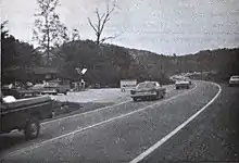
Northwest of Tazewell, the road bridges the Powell River, and then passes through Harrogate. In the town of Cumberland Gap, Tennessee, US 25E serves as the western terminus of US 58. US 25E used that highway en route to the Cumberland Gap prior to 1996; however, it now uses a new highway leading to the Cumberland Gap Tunnel, freeing up a portion of road that US 58 now uses. US 25E then passes through the tunnel, emerging on the other side in Kentucky.[1]
Kentucky
US 25E remains a multilane divided highway for its entire extent in Kentucky.[10] Upon departing the tunnel, the road heads west to the town of Middlesboro, Kentucky, where it intersects KY 74. US 25E turns north at Middlesboro toward Pineville, the county seat of Bell County. In Pineville, the route is the western terminus of US 119.
US 25E departs Pineville and heads northwest, indirectly serving Tinsley via KY 92, crossing into Knox County, and bypassing Flat Lick to the west. The route makes an S-shaped curve, dipping south then turning back northwest as it approaches Barbourville. After serving the east side of Barbourville, the highway passes near Heidrick and runs through Baileys Switch.
Between Baileys Switch and Gray, US 25E gradually turns more east–west. After running through Gray, the route serves as the northern terminus of KY 3041. The road then reunites with US 25W north of Corbin, and the unsuffixed US 25 continues to points north. However, the US 25E designation continues west to Interstate 75, where it ends at Exit 29.[11]
History
Before the Cumberland Gap Tunnel was opened in 1996, US 25E passed through the Cumberland Gap in Virginia. Prior to the U.S. highway system's arrival, Virginia's State Highway 10 began at the Cumberland Gap and proceeded to Bristol.[12] A short spur south to Tennessee was soon added, becoming State Route 107 in the 1923 renumbering, and State Route 100 in the 1928 renumbering.[13]
Early U.S. Highway planning assigned the number U.S. Route 411 to SR 10 through Cumberland Gap to Kentucky, and no number to SR 107.[14] By the final 1926 plan, US 411 was truncated to Cumberland Gap, and US 25E ran from Tennessee to Kentucky along SR 10 and SR 107.[2] The State Route numbers were dropped in the 1933 renumbering.
Through-out the 1970s to the 1990s, highway improvement projects conducted by a joint-effort between the Tennessee Department of Transportation (TDOT), the Federal Highway Administration (FHWA), and Appalachian Regional Commission (ARC), began to widen US 25E between the town of Cumberland Gap to Interstate 81 south of the city of Morristown, which was designated as Corridor S of the ARC's Appalachian Development Highway System (ADHS).[15]
Following the signing of the Intermodal Surface Transportation Efficiency Act in 1991, the US 25E corridor from Corbin, Kentucky to Morristown, Tennessee was defined as High-Priority Corridor 12, establishing US 25E as part of the National Highway System.[8]
Before the completion of the Cumberland Gap Tunnel, US 25E saw increased congestion following an uptick in truck traffic bypassing I-75 through Campbell County and Knoxville.[16]
Cumberland Gap project
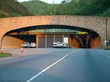
In the mid-to-late-20th century, US 25E between Middlesboro and Cumberland Gap had seen an uptick in fatal collisions, with the stretch of highway through the Cumberland Gap nicknamed "Massacre Mountain."[17] In 1973, officials with the National Park Service received initiatives to construct tunnels underneath the Cumberland Gap in order to resolve the accidents and restore the Cumberland Gap to its pioneer-era state of the 1770s, a motion set forth by the establishment of Cumberland Gap National Historical Park by the United States Congress in 1940. The plan, consisting of the construction of twin 4,600 foot long tunnels, five miles of new a four-lane controlled-access US 25E, two interchanges, seven bridges, and the restoration of the Cumberland Gap, was presented with a cost of $265 million dollars and was led by joint effort between the National Park Service and the Federal Highway Administration. Design work for the project started in 1979, and construction on the tunnels and the new four-lane 25E began in 1985.[17]
The Cumberland Gap Tunnel would open in 1996, completely bypassing Cumberland Gap and Virginia.[17] U.S. Route 58 was moved to a new alignment, meeting the new four-lane US 25E in Tennessee, decommissioning US 25E through Virginia. As old US 25E lied within the boundaries of the Cumberland Gap National Historical Park its pavement was torn up, and the path was restored into a hiking trail along the Wilderness Road through the Cumberland Gap.[18]
Major intersections
| State | County | Location | mi[11][1][19][20] | km | Exit | Destinations | Notes |
|---|---|---|---|---|---|---|---|
| Tennessee | Cocke | Newport | 0.0 | 0.0 | Southern terminus of US 25E; US 25E south and US 25W merge to form US 25; southern end of unsigned SR 32 concurrency | ||
| Douglas Lake/French Broad River | J. W. Walters Bridge | ||||||
| Jefferson | | Nina Road – Baneberry | Access road into Baneberry | ||||
| White Pine | 9.5 | 15.3 | Eastern terminus of SR 341 | ||||
| 11.1 | 17.9 | Southern end of SR 113 concurrency | |||||
| Hamblen | Morristown | 13.0 | 20.9 | I-81 exit 8 | |||
| 14.8 | 23.8 | Southern terminus of SR 343 | |||||
| 15.5 | 24.9 | Northern end of SR 113 concurrency | |||||
| 17.1 | 27.5 | 1 | Southern end of freeway; interchange | ||||
| 19 | 31 | 1A | College Square Drive/College Park Drive | Interchange | |||
| 19.5 | 31.4 | 2A | Southern end of US 11E/SR 34 concurrency; interchange | ||||
| 19.8 | 31.9 | 2B | Northern end of US 11E/SR 34 concurrency; northern end of freeway; interchange | ||||
| 22.3 | 35.9 | interchange; northern terminus of SR 343; southbound exit and northbound entrance; missing movements signed on Cherokee Park Road | |||||
| Cherokee Lake/Holston River | Olen R. Marshall Memorial Bridge | ||||||
| Grainger | Bean Station | 26.2 | 42.2 | Northern terminus of SR 375 | |||
| 29.3 | 47.2 | Southern end of US 11W/SR 1 concurrency; interchange | |||||
| 31.2 | 50.2 | Northern end of US 11W/SR 1 concurrency; interchange | |||||
| Thorn Hill | 38.6 | 62.1 | |||||
| Claiborne | | 45.5 | 73.2 | Southern end of SR 33 concurrency | |||
| Tazewell | 50.8 | 81.8 | Northern end of SR 33 concurrency | ||||
| 51.3 | 82.6 | Southern terminus of SR 345 | |||||
| Harrogate | 60.2 | 96.9 | Southern end of SR 63 concurrency | ||||
| 60.4 | 97.2 | Northern end of SR 63 concurrency | |||||
| Cumberland Gap | 61.2 | 98.5 | Interchange; western terminus of US 58/SR 383 | ||||
| Cumberland Gap | 65.9 0.000 | 106.1 0.000 | Cumberland Gap Tunnel | ||||
| Kentucky | Bell | Cumberland Gap NHP | 1.343 | 2.161 | Cumberland Gap National Park Visitor Center & Craft Shop | Interchange | |
| Middlesboro | 1.719 | 2.766 | |||||
| 2.781 | 4.476 | ||||||
| | 6.322 | 10.174 | |||||
| | 6.402 | 10.303 | |||||
| Ferndale | 8.313 | 13.378 | |||||
| | 8.900 | 14.323 | |||||
| | 11.604 | 18.675 | |||||
| Pineville | 12.355 | 19.883 | |||||
| 13.460 | 21.662 | ||||||
| 14.200 | 22.853 | ||||||
| | 17.360 | 27.938 | |||||
| | 17.576 | 28.286 | |||||
| Knox | | 19.075 | 30.698 | ||||
| | 20.309 | 32.684 | |||||
| | 21.543 | 34.670 | |||||
| | 21.709 | 34.937 | |||||
| | 22.471 | 36.164 | |||||
| | 24.081 | 38.755 | |||||
| | 25.581 | 41.169 | |||||
| Barbourville | 26.684 | 42.944 | |||||
| 27.418 | 44.125 | ||||||
| 28.470 | 45.818 | ||||||
| 29.439 | 47.377 | Southern end of KY 11 concurrency | |||||
| 29.596 | 47.630 | ||||||
| 30.205 | 48.610 | Northern end of KY 11 concurrency | |||||
| | 30.811 | 49.585 | |||||
| | 31.206 | 50.221 | |||||
| | 32.610 | 52.481 | |||||
| | 33.124 | 53.308 | |||||
| | 34.437 | 55.421 | |||||
| | 40.366 | 64.963 | |||||
| | 42.227 | 67.958 | |||||
| Corbin | 42.872 | 68.996 | |||||
| 44.301 | 71.296 | ||||||
| 44.593 | 71.765 | ||||||
| Laurel | North Corbin | 45.192 | 72.729 | US 25W and US 25E north merge to form US 25; US 25E signage continues | |||
| 45.703 | 73.552 | ||||||
| 46.805– 46.872 | 75.325– 75.433 | I-75 exit 29; northern terminus of US 25E | |||||
1.000 mi = 1.609 km; 1.000 km = 0.621 mi
| |||||||
See also
 U.S. roads portal
 United States portal
References
- Google (January 2, 2021). "U.S. Route 25E" (Map). Google Maps. Google. Retrieved January 2, 2021.
- Bureau of Public Roads; American Association of State Highway Officials (November 11, 1926). United States System of Highways Adopted for Uniform Marking by the American Association of State Highway Officials (Map). 1:7,000,000. Washington, DC: United States Geological Survey. OCLC 32889555. Retrieved November 7, 2013 – via Wikimedia Commons.
- O'Neil, Duay (October 20, 2009). "Hwy 25 East is Now a National Scenic Byway". The Newport Plain Talk. Archived from the original on July 14, 2011. Retrieved October 23, 2009.
- "ADHS Approved Corridors and Termini". Archived from the original on November 1, 2007.
- "Appalachian Development Highway System Completion Plan Report" (PDF). Appalachian Regional Commission. September 2013. Retrieved December 13, 2020.
- "Status of Corridors in Tennessee" (PDF). Appalachian Regional Commission. September 30, 2013. Archived from the original (PDF) on July 5, 2014. Retrieved June 30, 2014.
- Office of Highway Policy Information. "Figure 1-4: National Truck Network". Our Nation's Highways 2008. Federal Highway Administration. Retrieved February 5, 2021.
- "Intermodal Surface Transportation Efficiency Act of 1991, as Amended, §§1105(c)(12) and (f)(25)". Government Publishing Office. Retrieved July 12, 2020.
- "Eastern Tennessee" (Map). The Road Atlas (2008 Large Scale ed.). Rand McNally. p. 193.
- Official Highway Map (Map) (2008 ed.). Kentucky Transportation Cabinet.
- "HIS Official Milepoint Route Log Report (Laurel County)". Kentucky Transportation Cabinet. Retrieved January 19, 2010.
- State Highway Commission of Virginia (July 5, 1922). Minutes of the First Meeting of the State Highway Commission Created Under the Acts of 1922 (PDF) (Report). Richmond, VA: Commonwealth of Virginia., Proposed "State Highway System" for Virginia, as Recommended by the State Roads Committee, January 1918
- "VA 100". Virginia Highways Project.
- Secretary of Agriculture (November 18, 1925). Report of Joint Board on Interstate Highways, October 30, 1925 (Report). US Department of Agriculture.
- SR-32 Relocation, Appalachian Corridor S, Indian Creek to Briar Fork Creek, Grainger County Environmental Impact Statement. United States Federal Highway Administration. 1975. Retrieved January 2, 2021.
- Merchant, Heidi (October 15, 1999). "Cumberland Gap Tunnel Paves the Way for Economic Development". Union Express. Archived from the original on September 25, 2004. Retrieved February 3, 2021.
- "Cumberland Gap Highway Tunnel Celebrates 15th Anniversary". Cumberland Gap National Historical Park. National Park Service. October 11, 2011. Retrieved February 3, 2021.
- Cumberland Gap National Historical Park Map (PDF) (Map). National Park Service.
- "HIS Official Milepoint Route Log Report (Bell County)". Kentucky Transportation Cabinet. Retrieved January 19, 2010.
- "HIS Official Milepoint Route Log Report (Knox County)". Kentucky Transportation Cabinet. Retrieved January 19, 2010.
External links
| Wikimedia Commons has media related to U.S. Route 25E. |