Loudon County, Tennessee
Loudon County is a county in the U.S. state of Tennessee. It is located in the central part of East Tennessee. As of the 2010 census, the population was 48,556.[2] Its county seat is Loudon.[3]
Loudon County | |
|---|---|
| County of Loudon | |
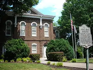 The Loudon County Courthouse in Loudon | |
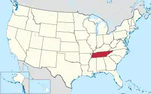
 Location within the U.S. state of Tennessee | |
 Tennessee's location within the U.S. | |
| Coordinates: 35°44′N 84°19′W | |
| Country | |
| State | |
| Founded | 1870 |
| Named for | Fort Loudoun[1] |
| Seat | Loudon |
| Largest city | Lenoir City (population) Loudon (area) |
| Government | |
| • County Mayor | Rollen "Buddy" Bradshaw |
| Area | |
| • Total | 247 sq mi (640 km2) |
| • Land | 229 sq mi (590 km2) |
| • Water | 18 sq mi (50 km2) 7.3%% |
| Population | |
| • Estimate (2019) | 54,068 |
| • Density | 212/sq mi (82/km2) |
| Time zone | UTC−5 (Eastern) |
| • Summer (DST) | UTC−4 (EDT) |
| Congressional district | 2nd |
| Website | www |
Loudon County is included in the Knoxville, TN Metropolitan Statistical Area.
History
Loudon County was formed on May 27, 1870, from portions of Roane, Monroe and Blount counties.[4] Originally, it was named Christiana County, but a few days later the name was changed to Loudon in honor of nearby colonial-era Fort Loudoun. The fort was named for John Campbell, 4th Earl of Loudoun and a commander of British forces during the French and Indian Wars. In August 1870, the county officers were chosen. On September 5, 1870, the county court was organized at the Baptist Church in Loudon. This church became the temporary quarters of the county court until the new building, built by J. W. Clark & Brothers, was finished in 1872.[4] Bussell Island, at the mouth of the Little Tennessee River, was inhabited by Native Americans for several thousand years before the arrival of the region's first European settlers.[5] The Overhill Cherokee village of Mialoquo was located along the Little Tennessee near modern Tellico Village.[6] Fort Loudoun was constructed by the British near modern Vonore in 1756, and was destroyed by the Cherokee four years later.
One of the earliest American settlements in what is now Loudon County was a river port and ferry known as Morganton, once located on the banks of the Little Tennessee River near modern Greenback. Morganton thrived during the early 19th century, but declined with the rise of the railroad in the latter half of the century. The town's remnants were inundated by Tellico Lake in the 1970s.[7]
Lenoir City is rooted in a plantation established by William Ballard Lenoir in 1810, which by the 1850s included a railroad stop known as Lenoir Station. The Lenoir City Company, established by Knoxville financiers Charles McClung McGhee and Edward J. Sanford, platted modern Lenoir City in the 1890s.[8]
The town of Loudon began as a ferry and later steamboat stop known as Blair's Ferry, established by James Blair and his brother-in-law, John Hudson Carmichael, in the 1810s. The town changed its name to "Loudon" during the early 1850s, when it expanded following the arrival of the railroad.[9] The railroad bridge at Loudon was one of eight bridges targeted for destruction by Union guerillas as part of the East Tennessee bridge-burning conspiracy in November 1861, at the outset of the Civil War. The bridge was too well-guarded by Confederate sentries, however, and the guerillas abandoned the effort.[10]
Geography

According to the U.S. Census Bureau, the county has a total area of 247 square miles (640 km2), of which 229 square miles (590 km2) is land and 18 square miles (47 km2) (7.3%) is water.[11]
The Little Tennessee River joins the Tennessee River at Lenoir City. The lower part of the Little Tennessee River is part of Tellico Lake, created by Tellico Dam near the mouth of the river. Fort Loudoun Dam spans the Tennessee River just upstream from its confluence with the Little Tennessee, creating Fort Loudoun Lake. The section of the river downstream from Fort Loudoun Dam is part of Watts Bar Lake.
Adjacent counties
- Knox County (northeast)
- Blount County (east)
- Monroe County (south)
- McMinn County (southwest)
- Roane County (northwest)
State protected areas
- Tellico Lake Wildlife Management Area (part)
Demographics
| Historical population | |||
|---|---|---|---|
| Census | Pop. | %± | |
| 1880 | 9,148 | — | |
| 1890 | 9,273 | 1.4% | |
| 1900 | 10,838 | 16.9% | |
| 1910 | 13,612 | 25.6% | |
| 1920 | 16,275 | 19.6% | |
| 1930 | 17,805 | 9.4% | |
| 1940 | 19,838 | 11.4% | |
| 1950 | 23,182 | 16.9% | |
| 1960 | 23,757 | 2.5% | |
| 1970 | 24,266 | 2.1% | |
| 1980 | 28,553 | 17.7% | |
| 1990 | 31,255 | 9.5% | |
| 2000 | 39,086 | 25.1% | |
| 2010 | 48,556 | 24.2% | |
| 2019 (est.) | 54,068 | [12] | 11.4% |
| U.S. Decennial Census[13] 1790-1960[14] 1900-1990[15] 1990-2000[16] 2010-2014[2] | |||
2010 census
As of the census of 2010,[18] there were 48,556 people, 19,826 households, and 14,483 families living in the county. The population density was 212.03 persons per square mile. The housing unit density was 86.58 units per square mile. The racial makeup of the county was 95.35% White, 1.11% African American, 0.28% Native American, 0.59% Asian, 0.10% Pacific Islander, and 1.08% from two or more races. 6.99% were Hispanic or Latino of any race.
Of the 19,826 households, 23.52% had children under the age of 18 living in them, 60.10% were married couples, 4.13% had a male householder with no wife present, 8.82% had a female householder with no husband present, and 16.95% were non-families. 23.21% were one person and 11.17% were one person aged 65 or older. The average household size was 2.42 and the average family size was 2.82.
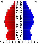
The age distribution was 20.32% under the age of 18, 58.19% ages 18 to 64, and 21.49% age 65 and older. The median age was 46.0 years. 50.93% of the population were females and 49.07% were males.
The median household income in the county was $49,343, and the median family income was $59,044. Males had a median income of $44,110, versus $29,441 for females. The per capita income for the county was $27,046. About 9.2% of families and 13.8% of the population were below the poverty line, including 23.8% of those under the age of 18 and 6.8% of those age 65 and over.
2000 census
At the 2000 census there were 39,086 people, 15,944 households, and 11,798 families living in the county. The population density was 171 people per square mile (66/km2). There were 17,277 housing units at an average density of 76 per square mile (29/km2). The racial makeup of the county was 95.90% White, 1.14% Black or African American, 0.32% Native American, 0.21% Asian, 0.02% Pacific Islander, 1.43% from other races, and 0.98% from two or more races. 2.29% of the population were Hispanic or Latino of any race.[19] Of the 15,944 households 28.40% had children under the age of 18 living with them, 61.70% were married couples living together, 8.90% had a female householder with no husband present, and 26.00% were non-families. 22.80% of households were one person and 10.10% were one person aged 65 or older. The average household size was 2.42 and the average family size was 2.82.
The age distribution was 21.90% under the age of 18, 6.70% from 18 to 24, 27.50% from 25 to 44, 27.70% from 45 to 64, and 16.20% 65 or older. The median age was 41 years. For every 100 females, there were 95.10 males. For every 100 females age 18 and over, there were 92.10 males.
The median household income was $40,401 and the median family income was $46,517. Males had a median income of $33,567 versus $23,164 for females. The per capita income for the county was $21,061. About 6.90% of families and 10.00% of the population were below the poverty line, including 12.80% of those under age 18 and 9.00% of those age 65 or over.
Education
The public schools in all areas of the county except Lenoir City are operated by Loudon County Schools.
Loudon County Schools
- Loudon High School
- Greenback School (K-12)
- Fort Loudoun Middle School
- North Middle School
- Eaton Elementary School
- Highland Park Elementary School
- Loudon Elementary School
- Philadelphia Elementary School
- Steekee Elementary School
- Loudon County Technology Center
Lenoir City Schools
- Lenoir City High School
- Lenoir City Intermediate/Middle School
- Lenoir City Elementary School
Politics
| Year | Republican | Democratic | Third Parties |
|---|---|---|---|
| 2016 | 75.3% 17,610 | 21.0% 4,919 | 3.7% 862 |
| 2012 | 75.7% 16,707 | 22.9% 5,058 | 1.4% 308 |
| 2008 | 71.3% 15,815 | 27.3% 6,058 | 1.4% 311 |
| 2004 | 70.7% 14,041 | 28.7% 5,708 | 0.6% 115 |
| 2000 | 62.6% 10,266 | 36.0% 5,905 | 1.4% 235 |
| 1996 | 51.7% 7,097 | 40.4% 5,552 | 7.9% 1,081 |
| 1992 | 47.7% 6,444 | 40.1% 5,414 | 12.2% 1,652 |
| 1988 | 66.7% 7,122 | 32.6% 3,480 | 0.7% 77 |
| 1984 | 68.4% 7,113 | 31.0% 3,227 | 0.6% 65 |
| 1980 | 61.5% 6,382 | 35.7% 3,699 | 2.8% 295 |
| 1976 | 48.3% 4,458 | 50.7% 4,683 | 1.0% 92 |
| 1972 | 75.1% 5,357 | 22.5% 1,604 | 2.4% 170 |
| 1968 | 54.6% 4,299 | 20.1% 1,581 | 25.3% 1,996 |
| 1964 | 55.2% 4,148 | 44.8% 3,365 | |
| 1960 | 65.5% 5,356 | 33.3% 2,722 | 1.3% 103 |
| 1956 | 60.9% 4,583 | 37.8% 2,844 | 1.3% 97 |
| 1952 | 66.5% 4,311 | 33.0% 2,138 | 0.5% 32 |
| 1948 | 57.7% 2,605 | 37.1% 1,673 | 5.3% 237 |
| 1944 | 65.7% 3,147 | 34.1% 1,632 | 0.2% 8 |
| 1940 | 51.6% 2,226 | 47.9% 2,068 | 0.5% 23 |
| 1936 | 52.0% 2,343 | 47.6% 2,146 | 0.4% 18 |
| 1932 | 51.9% 1,817 | 46.5% 1,629 | 1.6% 57 |
| 1928 | 78.2% 2,127 | 21.7% 589 | 0.1% 3 |
| 1924 | 66.6% 1,533 | 30.5% 703 | 2.9% 66 |
| 1920 | 72.7% 1,872 | 26.6% 686 | 0.7% 17 |
| 1916 | 62.1% 698 | 37.6% 423 | 0.3% 3 |
| 1912 | 29.5% 322 | 38.0% 415 | 32.5% 354 |
References
- Origins Of Tennessee County Names, Tennessee Blue Book 2005-2006, pages 508-513
- "State & County QuickFacts". United States Census Bureau. Archived from the original on June 7, 2011. Retrieved December 3, 2013.
- "Find a County". National Association of Counties. Retrieved 2011-06-07.
- Joe Spence, "Loudon County," Tennessee Encyclopedia of History and Culture. Retrieved: 22 October 2013.
- M.R. Harrington, Cherokee and Earlier Remains on Upper Tennessee River (New York: Museum of the American Indian, Heye Foundation, 1922), pp. 61–82.
- Kurt Russ and Jefferson Chapman, Archaeological Investigations at the Eighteenth Century Overhill Cherokee Town of Mialoquo (40MR3) (University of Tennessee Department of Anthropology, Report of Investigations 37, 1983), pp. 16-18.
- James Polhemus and Richard Polhemus, An Assessment of the Archaeological Potential of Townsite of Morganton in Loudon County, Tennessee (Knoxville, Tenn.: Tennessee Valley Authority, 1978), pp. 1-2.
- John Benhart, Appalachian Aspirations: The Geography of Urbanization and Development in the Upper Tennessee River Valley, 1865-1900 (Knoxville, Tenn.: University of Tennessee Press, 2007), pp. 74-79.
- Benhart, Appalachian Aspirations, pp. 23-25.
- Oliver Perry Temple, East Tennessee and the Civil War (Cincinnati: The Robert Clark Company, 1899), pp. 370–406.
- "2010 Census Gazetteer Files". United States Census Bureau. August 22, 2012. Retrieved April 7, 2015.
- "Population and Housing Unit Estimates". Retrieved July 20, 2019.
- "U.S. Decennial Census". United States Census Bureau. Retrieved April 7, 2015.
- "Historical Census Browser". University of Virginia Library. Retrieved April 7, 2015.
- Forstall, Richard L., ed. (March 27, 1995). "Population of Counties by Decennial Census: 1900 to 1990". United States Census Bureau. Retrieved April 7, 2015.
- "Census 2000 PHC-T-4. Ranking Tables for Counties: 1990 and 2000" (PDF). United States Census Bureau. April 2, 2001. Retrieved April 7, 2015.
- Based on 2000 census data
- "U.S. Census website". United States Census Bureau. Retrieved 2019-09-19.
- "U.S. Census website". United States Census Bureau. Retrieved 2011-05-14.
- Leip, David. "Dave Leip's Atlas of U.S. Presidential Elections". uselectionatlas.org. Retrieved 2018-03-11.
External links
| Wikimedia Commons has media related to Loudon County, Tennessee. |
- Official site
- Loudon County at Curlie
- Loudon County, TNGenWeb - free genealogy resources for the county
Places adjacent to Loudon County, Tennessee | ||||||||||
|---|---|---|---|---|---|---|---|---|---|---|
| ||||||||||
Municipalities and communities of Loudon County, Tennessee, United States | ||
|---|---|---|
| Cities | ||
| Towns | ||
| CDP | ||
| Unincorporated communities | ||
| Footnotes | ‡This populated place also has portions in an adjacent county or counties | |
| ||
| Principal City |   | |
|---|---|---|
| Other Cities | ||
| Counties | ||

| Authority control |
|---|