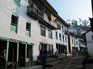
Bhojpur Municipality
Bhojpur (Nepali: भोजपुर) is one of the two urban municipalities of Bhojpur District of Province No. 1 of Nepal.
Bhojpur Municipality
भोजपुर नगरपालिका | |
|---|---|
 Bhojpur Municipality | |
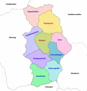 Map of Bhojpur District showing all local level units | |
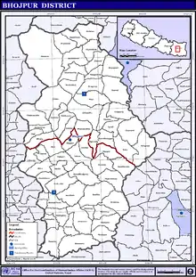
 Bhojpur Municipality Location in Province No. 1  Bhojpur Municipality Bhojpur Municipality (Nepal) | |
| Coordinates: 27°10′N 87°3′E | |
| Country | |
| Province | Province No. 1 |
| District | Bhojpur District |
| Wards | 12 |
| Headquarter | Bhojpur |
| Government | |
| • Type | Mayor-council |
| • Mayor | Kailash Kumar Ale (NC) |
| • Deputy Mayor | Mamita Rai (NCP) |
| Area | |
| • Total | 159.51 km2 (61.59 sq mi) |
| Population (2011) | |
| • Total | 27,204 |
| • Density | 170/km2 (440/sq mi) |
| Time zone | NST |
| Postal code | 57000 |
| Area code(s) | 029 |
| GDP (Nominal) | 2017 |
| - Total | RsBillion $Million(Billion, PPP) |
| - per capita | Rs $(PPP) |
| - GDP growth | Moderate (2016) |
| Licence plate prefixes | initiating with Province No 1,Koshi Zone |
| City flower | Rhododendron |
| City trees | Orange, Rudraksha and Amba |
| Climate | Cwb |
| Website | www |
Bhojpiur is the traditional home of Kirat Rai people and has a long history since the settlement of the Kirat Rai people. Bhojpur bazaar is famous for its metalwork, particularly khukuri knives and Karuwa (metal vessel). It is home to many businessmen as well as skilled craftsmen. Other major towns in the district include Dingla to the north, Ghoretar to the south, and Taksar near the airstrip, from where flights connect to Biratnagar and Kathmandu.
The design and construction of the 240 km Koshi Highway in east Nepal between Dharan on the Terai Plain and Num in the Middle Himalaya commenced in the early 1970s and was completed in 2012 when the first vehicles were able to drive to Num.[1] Construction of this highway links Bhjopur to other major cities and towns like Hile, Dhankuta and Dharan.
Historically it is a part of Majh Kirat (middle Kirat/ Khambuwan), and used to be called "east number 4". Middle Kirat consists mainly of Bhojpur and Khotang districts, the traditional home of kirat Rai people, an indigenous ethnic group of Nepal. In addition to Rais, other ethnic groups include castes like Chhetris, Bahuns, and Dalits.
Background
_before_2017.jpg.webp)
Bhojpur was a VDC in Bhojpur District before 2014. According to the 2011 Nepal census it had total population of 7,446 with 2,070 households.[2]
On 18 May 2014 Government of Nepal declared 72 new municipality within the hole country.[3] Same time Bhojpur Municipality declared, incorporating Bhojpur, Bhaisipankha, Bokhim and Taksar VDCs diving in 11 ward units.
In March 2017, the Government of Nepal restructured all the local level bodies of Nepal into 753 new local level structures. [4] [5] The previous Aamtep, Helauchha, Siddheshwar and Gupteshwar VDCs merged again in Bhojpur Municipality and rearranged the 11 wards into 12 wards.
Now total area of the municipality is 159.51 square kilometres (61.59 sq mi) and total population according to the 2011 Nepal census is 27,204. The admin headquarter of the municipality is located at Bhojpur Bazar (ward no. 7).[6]
| Former VDC | Ward | Area (KM²) | Population | Map |
|---|---|---|---|---|
| Helauchha | 1 | 19.08 | 1500 | 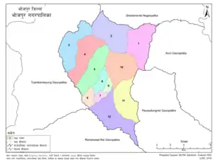 |
| 2 | 20.77 | 2211 | ||
| Gupteshwar | 3 | 17.31 | 1914 | |
| Siddheshwar | 4 | 17.47 | 2842 | |
| Bokhim | 5 | 16 | 2882 | |
| Bhojpur | 6 | 4.03 | 1710 | |
| 7* | 2.29 | 2805 | ||
| 8 | 4.75 | 1160 | ||
| 9 | 2.38 | 1771 | ||
| Bhaisipankha | 10 | 18.28 | 2434 | |
| Aamtep | 11 | 16.44 | 2635 | |
| Taksar | 12 | 20.72 | 33.50 |
Constituency
Bhojpur Municipality is divide into two Provincial constituencies as below:
| Constituency | MLA | Party | Ward No. | Neighborhood | |
|---|---|---|---|---|---|
| Bhojpur 1(A) | Rajendra Kumar Rai | Nepal Communist Party | 1 & 2 | Helauchha | |
| 3 | Gupteshwar | ||||
| 4 | Siddheshwar | ||||
| 5 | Bokhim | ||||
| 10 | Bhaisipankha | ||||
| Bhojpur 1(B) | Sher Dhan Rai | Nepal Communist Party | 6, 7, 8, 9 |
Bhojpur | |
| 11 | Aamtep | ||||
| 12 | Taksar | ||||
People
Religion
College & Universities
- Bhojpur Multiple Campus
- [[Nucleus Academy ]]
- Bidhyodaya Higher Secondary School
- PanchaKanya Secondary School
- Yasodhara Higher Secondary School
- Sidheswor Higher Secondary School
- Teachers Training Center
- Shree Janodaya Secondary School
- Shree Tyamke Primary School
- Shree Jaunagi Adharbhut School
Tourism Spots
- Suntale Danda
- Bhojpur Airport
- Bokhim
- Bhaisipankha
- Dipsha Village
- Tyamke Dada
- Maiyung Dada
- Shilichung
- Hatuwagadhi
- Siktel And Pikhuwa KHola
- Taksar Temple
- Siddhakali Temple
- [[Bhojpur Bazar]]
Notable People
- Ram Prasad Rai
- Dayahang Rai
- Bidhya Devi Bhandari
- Babu Bhogati
- Sher Dhan Rai
References
- Hearn, G. J. (2017-07-27). "Engineering geomorphology of the Koshi Highway, east Nepal". Quarterly Journal of Engineering Geology and Hydrogeology. 50 (3): qjegh2016–112. doi:10.1144/qjegh2016-112. ISSN 1470-9236.
- "National Population and Housing Census 2011 (Village Development Committee" (PDF). MOFALD. 2011. Retrieved 17 January 2021.
- "Government announces 72 new municipalities". The Kathmandu Post. Retrieved 2014-06-10.
- "New local level structure comes into effect from today". www.thehimalayantimes.com. The Himalayan Times. 10 March 2017. Retrieved 17 July 2018.
- "New local level units come into existence". www.kathmandupost.ekantipur.com. 11 March 2017. Retrieved 18 July 2018.
- "District Corrected Last for RAJAPATRA" (PDF). www.mofald.gov.np. Retrieved 17 July 2018.
