Bhojpur District, Nepal
Bhojpur District (Nepali: भोजपुर जिल्ला [bʱod͡zpur] (![]() listen)) is one of 14 districts of Province No. 1 of eastern Nepal. The district's area is 1,507 km² with a population of 182,459 (2011).[1] The administrative center is Bhojpur. It is surrounded by Dhankuta and Sankhuwasabha in the east, Khotang in the west, again Sankhuwasabha in north-east and Solukhumbu in the north-west and Udayapur in the South.
listen)) is one of 14 districts of Province No. 1 of eastern Nepal. The district's area is 1,507 km² with a population of 182,459 (2011).[1] The administrative center is Bhojpur. It is surrounded by Dhankuta and Sankhuwasabha in the east, Khotang in the west, again Sankhuwasabha in north-east and Solukhumbu in the north-west and Udayapur in the South.
Bhojpur District
भोजपुर जिल्ला | |
|---|---|
District | |
 Chandi Bazar: A famous spot of Kirat Rai Ubhauli festival in Balankha | |
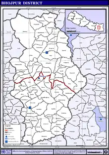
 Location of Bhojpur district | |
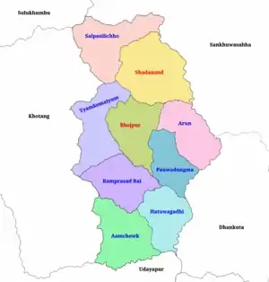 Political division of Bhojpur | |
| Coordinates: 27°10′21″N 87°02′53″E | |
| Country | |
| Province | Province No. 1 |
| Admin HQ. | Bhojpur |
| Municipality | |
| Government | |
| • Type | Coordination committee |
| • Body | DCC, Bhojpur |
| • Head | Mr. Laxman Khadka |
| • Deputy-Head | Mrs. Anisha Khadka |
| • Parliamentary constituencies | 1 |
| • Provincial constituencies | 2 |
| Area | |
| • Total | 1,507 km2 (582 sq mi) |
| Highest elevation | 4,153 m (13,625 ft) |
| Lowest elevation | 153 m (502 ft) |
| Population (2011) | |
| • Total | 182,459 |
| • Households | 39,393 |
| Demographics | |
| • Ethnic groups | Rai, Chetri, Tamang |
| • Female ♀ | 53% |
| • Male ♂/100 female | 89.96 |
| Human Development Index | |
| • Income per capita (US dollars) | $999 |
| • Poverty rate | 24.4 |
| • Literacy | 69% |
| • Life Expectancy | 68.3 |
| Time zone | UTC+05:45 (NPT) |
| Postal Codes | 57000, 57001..., 57015 |
| Telephone Code | 029 |
| Main Language(s) | Nepali, Rai, Tamang |
| Major highways | Mid-Hills Highway |
| Website | ddcbhojpur |
Etymology
According to the DCC Bhojpur, this place was named after the Betula utilis. Betula utilis was found here in large quantities. The Nepali name for Betula utilis is "Bhojpatra" (भोजपत्र).[2]
"Bhojpur" is a combination of two words "Bhoj" and "Pur", Bhoj refers to Bhojpatra (Betula utilis) and "Pur refers to a place or city.
According to history, Prithvi Narayan Shah gave a big party after winning a battle in this place. The Meaning of "Bhojpur" means party and "Pur" meaning "buried". After the party the food was more than enough for them and they were unable to eat it all. After that the Nepali armies buried all their wasted food here. So the name became Bhojpur.
Geography and climate
Classified as a Hill District, Bhojpur actually spans five of Nepal's eight climate zones.[3] 3% of the district's area is below 300 meters elevation in the Lower Tropical zone and 31% is Upper Tropical from 300 to 1,000 meters. 50% of the land area belongs to the Subtropical Zone between 1,000 and 2,000 meters and 15% is Temperate (2,000 to 3,000 meters). 2% rises higher into the Subalpine Zone.
| Climate Zone[4] | Elevation Range | % of Area |
|---|---|---|
| Lower Tropical | below 300 meters (1,000 ft) | 2.7% |
| Upper Tropical | 300 to 1,000 meters 1,000 to 3,300 ft. |
30.5% |
| Subtropical | 1,000 to 2,000 meters 3,300 to 6,600 ft. |
49.8% |
| Temperate | 2,000 to 3,000 meters 6,400 to 9,800 ft. |
15.1% |
| Subalpine | 3,000 to 4,000 meters 9,800 to 13,100 ft. |
1.7% |
Divisions
Bhojpur is divided into two urban and seven rural municipalities:
| No. | Type | Name | Population (2011) | Area | Wards | Website |
|---|---|---|---|---|---|---|
| 1 | Urban | Bhojpur | 28,107 | 159.51 | 12 | |
| 2 | Urban | Shadanand | 31,612 | 241 | 14 | |
| 3 | Rural | Hatuwagadhi | 20,404 | 142.61 | 9 | |
| 4 | Rural | Ramprasad Rai | 18,848 | 158.83 | 8 | |
| 5 | Rural | Aamchok | 18,720 | 184.89 | 10 | |
| 6 | Rural | Tyamke Maiyunm | 17,911 | 173.41 | 9 | |
| 7 | Rural | Arun Gaunpalika | 17,687 | 154.76 | 7 | |
| 8 | Rural | Pauwadungma | 15,394 | 118.86 | 6 | |
| 9 | Rural | Salpasilichho | 13,111 | 193.33 | 6 | |
| District | Bhojpur | 182,459 | 1,507 | 81 |
Towns and villages (former VDC)
- Aangtep
- Annapurna
- Baikunthe
- Balankha
- Basikhora
- Basingtharpu
- Bastim
- Bhaisipankha
- Bhubal
- Bhulke
- Bokhim
- Bhojpur
- Boya
- Champe
- Changre
- Charambi
- Chaukidanda
- Chhinamakhu
- Dalgaun
- Deurali
- Dewantar
- Dhodalekhani
- Dobhane
- Dummana
- Gogane
- Gupteshwar
- Hasanpur
- Helauchha
- Homtang
- Jarayotar
- Kimalung
- Keurepani
- Khairang
- Khartimchha
- Khatamma
- Khawa
- Kot
- Kudak Kaule
- Kulunga
- Lekharka
- Mane Bhanjyang
- Mulpani
- Nagi
- Nepaledada
- Okhre
- Pangcha
- Patle Pani
- Pawala
- Pyauli
- Ranibas
- Sangpang
- Sano Dumba
- Shadanand Municipality
- Shyamsila
- Siddheshwar
- Sindrang
- Syamsila
- Taksar
- Thidingkha
- Thulo Dumba
- Timma
- Tiwari Bhanjyang
- Tunggochha
- Yaku
- Yangpang
- Chaukidada
Demographics
At the time of the 2011 Nepal census, Bhojpur District had a population of 182,459. Of these, 49.1% spoke Nepali, 19.6% Bantawa, 7.5% Tamang, 4.5% Newari, 3.4% Magar, 3.0% Dungmali, 2.4% Kulung, 2.0% Sampang, 1.5% Sherpa, 1.4% Rai, 1.2% Chamling and 0.7% Nachhiring as their first language.
48.5% of the population in the district spoke Nepali and 0.6% Bantawa as their second language.[5]
53% of the population are female. Major ethnicities in the district are Rai (32%), Chhetri (20%), Tamang (9%), Newar (8%), Bahun (6%) and others (25%). The literacy rate is 69 percent.[6]
2015 Nepal earthquake
The district was affected by an earthquake on 25 April 2015.[7]
See also
References
- "National Population and Housing Census 2011(National Report)" (PDF). Central Bureau of Statistics. Government of Nepal. November 2012. Archived from the original (PDF) on 18 April 2013. Retrieved 1 November 2012.
- "संक्षिप्त परिचय". dccbhojpur.gov.np. DCC Bhojpur. Retrieved 25 January 2020.
- The Map of Potential Vegetation of Nepal – a forestry/agroecological/biodiversity classification system (PDF), . Forest & Landscape Development and Environment Series 2-2005 and CFC-TIS Document Series No.110., 2005, ISBN 87-7903-210-9, retrieved 22 November 2013
- The Map of Potential Vegetation of Nepal – a forestry/agroecological/biodiversity classification system (PDF), . Forest & Landscape Development and Environment Series 2-2005 and CFC-TIS Document Series No.110., 2005, ISBN 87-7903-210-9, retrieved 22 November 2013
- 2011 Nepal Census, Social Characteristics Tables
- "Bhojpur district in Nepal". nepalmap.org. Retrieved 6 March 2018.
- "Nepal family finds starting over tough in wake of earthquake". nwi.com. The Times. 13 June 2015. Retrieved 21 June 2015.
Further reading
- "Districts of Nepal". Statoids.
External links
Places adjacent to Bhojpur District, Nepal | ||||||||||
|---|---|---|---|---|---|---|---|---|---|---|
| ||||||||||
Headquarter: Bhojpur | ||
| Urban Municipality | | |
| Rural Municipality | ||
For former VDCs See here
| ||
| Wikimedia Commons has media related to Bhojpur District, Nepal. |