Bighorn Canyon National Recreation Area
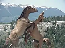
Bighorn Canyon National Recreation Area is a national park unit established by an act of Congress on October 15, 1966, following the construction of the Yellowtail Dam by the Bureau of Reclamation. It straddles the border between Wyoming and Montana.[3] The dam, named after the famous Crow leader Robert Yellowtail, harnesses the waters of the Bighorn River by turning that variable watercourse into Bighorn Lake.[3] The lake extends 71 miles (114 km) through Wyoming and Montana, 55 miles (89 km) of which lie within the national recreation area.[3] About one third of the park unit is located on the Crow Indian Reservation.[4] Nearly one-quarter of the Pryor Mountains Wild Horse Range lies within the Bighorn Canyon National Recreation Area.[5]
| Bighorn Canyon National Recreation Area | |
|---|---|
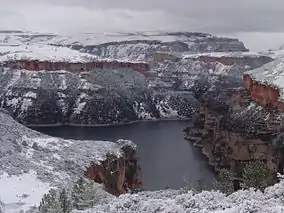 Snowfall on the Bighorn Canyon in the North District | |
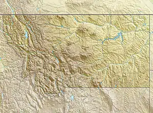  | |
| Location | Big Horn and Carbon counties, Montana & Big Horn County, Wyoming, USA |
| Nearest city | Billings, Montana |
| Coordinates | 45°11′40″N 108°7′50″W |
| Area | 120,296.22 acres (486.8215 km2)[1] |
| Established | October 15, 1966 |
| Visitors | 201,010 (in 2011)[2] |
| Governing body | National Park Service |
| Website | Bighorn Canyon National Recreation Area |

Park features
Afterbay Lake, located below Yellowtail Dam, is a popular spot for trout fishing as well as for viewing ducks, geese and other animals.[6] The Bighorn River below the Afterbay Dam is likewise a world-class trout fishing area.[6][7] In addition, the area features many archeological and historical resources.[8] Visitor centers and other developed facilities are located in Fort Smith, Montana and near Lovell, Wyoming.[3]
Bighorn Canyon National Recreation Area has four historic ranches within its boundaries:[9]
- L Slash Heart Ranch was owned by Caroline Lockhart, a notable journalist and novelist in the early 1900s.[10] Two of her books were made into silent films in the 1920s.[10]
- Mason-Lovell Ranch was operating during the open range days of the 1880s; the ranch once had 25,000 cattle roaming the entire Bighorn Basin.[11]
- Cedarvale Ranch, located in the ghost town of Hillsboro, Montana, was a dude ranch owned by native New Yorker Grosvener W. "Doc" Barry, and attracted people for vacations.[12] Visitors included Doc Barry's friend President Teddy Roosevelt, but attracting other vacationers proved more difficult.[12]
- Ewing-Snell Ranch is a former family ranch started by Erastus Ewing.[13] Ewing went west to get rich in gold mining, but he was not successful in the gold fields and turned to ranching.[13]
North of Lovell along the Sullivan Knob's Trail is one of the national recreation area's more unusual claims to fame.[14] There a visitor can stand in a certain spot on the canyon rim, shout across the canyon and then hear a "triple echo" in reply.[14]
The Bad Pass Trail runs through the Bighorn Canyon National Recreation Area. For thousands of years, this trail was used by prehistoric indigenous peoples, who may also have been following paths made by migrating game. During the winter, the prehistoric people would travel southward on the trail to reach the caves in the canyon, where they took shelter. In the spring, they would travel northward to hunting grounds in what is now called Montana. The trail is considered a cultural or sacred site by Native Americans, and in the 21st century, no one is allowed to walk or drive on it.
In the mid-19th century, fur trappers and traders known as mountain men used the trail when they were in the area. They named it as the Bad Pass Trail because of its ruggedness. Jim Bridger, a noted mountain man of this period, was the first person known to float a boat down the Bighorn River and leave a record of his trip. He said the rapids, when he made his trip in 1825, seemed to charge the water like foam.
See also
References
- "Listing of acreage as of December 31, 2011". Land Resource Division, National Park Service. Retrieved 2012-12-16.
- "NPS Annual Recreation Visits Report". National Park Service. Retrieved 2012-12-26.
- "Management: Bighorn Canyon National Recreation Area". National Park Service. Retrieved 2013-11-25.
- "The National Parks Index 2009-2011". National Park Service. Archived from the original on 2013-12-03. Retrieved 2013-11-25.
- "Wild Horses." Billings Field Office. Bureau of Land Management. United States Department of the Interior. May 2, 2011. Archived June 16, 2015, at the Wayback Machine Accessed 2011-05-18.
- "Federal Register, Volume 70, Issue 104 (July 1, 2005), pp. 31345-31353". Government Printing Office. Retrieved 2013-11-16.
- Maffly, Brian (2007). "Battle on the Bighorn: Holding back water for Bighorn Lake recreation could doom the world-class trout fishery downstream". Montana Outdoors. Montana Fish, Wildlife & Parks. Retrieved 2010-12-07.
- "Nature & Science: Bighorn Canyon National Recreation Area". National Park Service. Retrieved 2013-11-25.
- "Bighorn Canyon National Recreation Area, Lowell, Wyoming". National Park Service. Archived from the original on 2012-07-29. Retrieved 2013-11-26.
- Clayton, John. "The Old West's Female Champion: Caroline Lockhart and Wyoming's Cowboy Heritage". Wyoming State Historical Society, WyoHistory.org. Retrieved 2013-11-26.
- Albert, Saige. "Historic ranch makes its mark: Mason-Lovell influences Big Horn Basin cattle". Wyoming Livestock Roundup. Retrieved 2013-11-26.
- "Doc Barry and the Voyage of the Edith". National Park Service. Retrieved 2013-11-26.
- "The Erastus Ewing". National Park Service. Retrieved 2013-11-26.
- "Sullivan's Knob Trail: Bighorn Canyon National Recreation Area". National Park Service. Retrieved 2013-11-25.
Further reading
- Edwin C. Bearss. "Historic Structures Report and History Research Study" (PDF). National Park Service. Archived from the original (PDF) on 2012-11-13. Retrieved 2012-12-10.
- Edwin C. Bearss (1970). "Bighorn Canyon National Recreation Area-Montana-Wyoming History Basic Data Volume 1" (PDF). Archived from the original (PDF) on 2012-11-13. Retrieved 2012-12-10.
- Edwin C. Bearss (1970). "Bighorn Canyon National Recreation Area-Montana-Wyoming History Basic Data Volume 2" (PDF). Archived from the original (PDF) on 2012-11-13. Retrieved 2012-12-10.
External links
| Wikimedia Commons has media related to Bighorn Canyon National Recreation Area. |
- "Bighorn National Recreation Area". National Park Service.
- "Bighorn Canyon National Recreation Area tour". MontanaPictures.net.
| Authority control |
|---|