Bighorn National Forest
The Bighorn National Forest is a U.S. National Forest located in northern Wyoming, United States and consists of over 1.1 million acres (4,500 km²). Created as a US Forest Reserve in 1897, it is one of the oldest government-protected forest lands in the U.S. The forest is well east of the continental divide and extends from the Montana border for a distance of 80 miles (130 km) along the spine of the Bighorn Mountains, an outlying mountain range separated from the rest of the Rocky Mountains by Bighorn Basin. Elevations range from 5,000 feet (1,500 m) along the sagebrush and grass-covered lowlands at the foot of the mountains, to 13,189 feet (4,020 m) on top of Cloud Peak, the highest point in the Bighorn Mountains. Around 99% of the land is above 1,500 metres (4,900 ft).[3] The forest is named after the Bighorn River, which is partially fed by streams found in the forest. Streams in the range are fed primarily by snowmelt and snowmelt mixed with driving rainfall.[3]
| Bighorn National Forest | |
|---|---|
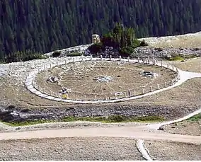 The Medicine Wheel National Historic Landmark in the National Forest | |
  | |
| Location | Sheridan, Big Horn, Johnson, and Washakie counties, Wyoming, USA |
| Nearest city | Sheridan, WY |
| Coordinates | 44°32′N 107°21′W |
| Area | 1,107,571 acres (4,482.18 km2)[1] |
| Established | February 22, 1897[2] |
| Governing body | U.S. Forest Service |
| Website | Bighorn National Forest |
Within the forest is the Cloud Peak Wilderness area in which no motorized or mechanical equipment is allowed. The only access into the 189,000 acre (765 km²) wilderness[4] is on foot or horseback. There are 1,500 miles (2,400 km) of trails in the forest, along with 32 improved campgrounds, lodges, and three scenic vehicular byways. U.S. Route 14 in Wyoming, also known as the Bighorn Scenic Byway, crosses the middle of the 30-mile (48 km) wide forest. The Medicine Wheel Passage (U.S. Highway 14A) crosses in the north passing the Medicine Wheel National Historic Landmark, while the Cloud Peak Skyway (U.S. Route 16) crosses the highest pass in the forest (Powder River Pass 9,677 ft/ 2,950 m) and is located in the southern section of the forest.
The forest headquarters is located in Sheridan, Wyoming. There are local ranger district offices in Buffalo, Lovell, and Sheridan.[5] Visitor centers are located at Burgess Junction and near Shell Falls.
History
The Bighorn National Forest was established as the Big Horn National Forest in 22 February 1897, and encompasses 1,198,080 acres. On 1 July 1908 the name was changed to the Bighorn National Forest through an executive order. In September 1981 the national forest had 1,115,171 acres, with 1,107,670 of those acres being National Forest land.[6]
Ecology and recreation
The Bighorn National Forest contains primarily forest along with alpine meadows and lakes at higher elevations. The forest is primarily lodgepole pine, along with several species of spruce, fir, and aspen. While grizzly bears have not inhabited the forest since the early 20th century, black bears are widespread. Other large mammals include cougars, elk, mule deer, pronghorn, and moose. Coyotes are also present in this forest. Numerous lakes are found within the forest and most are naturally stocked with trout and at least 100 other fish species. Meadowlark Lake is a popular recreation area created by the construction of a dam built by Company 841 of the Civilian Conservation Corps in 1936. Water quality sampling from the lakes shows the highest acid rain deposition of any mountain chain in the Rockies.
Gallery
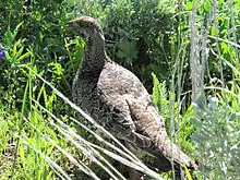 Sage Grouse in Bighorn National Forest
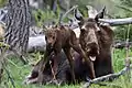 A mother and child moose near the Shell Ranger Station
 A northern flicker in a tree
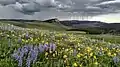 Wildflowers blooming in the short high altitude summer

References
- "Land Areas of the National Forest System" (PDF). U.S. Forest Service. January 2012. Retrieved June 30, 2012.
- "The National Forests of the United States" (PDF). Forest History Society. Retrieved July 30, 2012.
- wohl, Ellen; cooper, david; Poff, LeRoy; Rahel, Frank; Staley, Dennis; Winters, David. "Assessment of Stream Ecosystem Function and Sensitivity in the Bighorn National Forest, Wyoming" (PDF).
- Forest Service
- USFS Ranger Districts by State
- "The National Forests of the United States" (PDF). Forest History Society. Retrieved July 30, 2012.
Further reading
- Georgen, Cynde. In the shadow of the Bighorns: A history of early Sheridan and the Goose Creek valley of northern Wyoming. Sheridan, Wyoming: Sheridan County Historical Society, 2010. ISBN 978-0-9792871-7-6