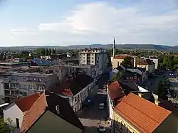
Bihać
Bihać (Serbian Cyrillic: Бихаћ) is a city and the administrative center of Una-Sana Canton of the Federation of Bosnia and Herzegovina, an entity of Bosnia and Herzegovina. It is situated on the banks of river Una in northwestern Bosnia and Herzegovina, in the Bosanska Krajina region. As of 2013, it has a population of 56,261 inhabitants.
Bihać
Bihać | |
|---|---|
| Grad Bihać City of Bihać | |
.jpg.webp) | |
 Coat of arms | |
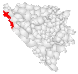 Location of Bihać within Bosnia and Herzegovina. | |
 Bihać Location in Bosnia and Herzegovina | |
| Coordinates: 44°49′N 15°52′E | |
| Country | |
| Entity | Federation of Bosnia and Herzegovina |
| Canton | Una-Sana Canton |
| Government | |
| • Mayor | Šuhret Fazlić (POMAK) |
| Area | |
| • City | 900 km2 (300 sq mi) |
| • Urban | 163 km2 (63 sq mi) |
| Elevation | 230 m (750 ft) |
| Population (2013 census)[1] | |
| • City | 43,007 |
| • Density | 48/km2 (120/sq mi) |
| • Urban | 56,261 |
| Time zone | UTC+1 (CET) |
| • Summer (DST) | UTC+2 (CEST) |
| ZIP code | 77000 |
| Area code(s) | +387 37 |
| Website | www |
Settlements
- Bajrići
- Brekovica
- Bugar
- Ćukovi
- Doljani
- Donja Gata
- Dubovsko
- Gorjevac
- Grabež
- Grmuša
- Hrgar
- Izačić
- Jezero
- Kalati
- Kulen Vakuf
- Lohovo
- Lohovska Brda
- Mala Peća
- Mali Skočaj
- Međudražje
- Muslići
- Ostrovica
- Papari
- Praščijak
- Pritoka
- Račić
- Rajinovci
- Ripač
- Spahići
- Srbljani
- Velika Gata
- Veliki Skočaj
- Veliki Stjenjani
- Vikići
- Vrsta
- Zavalje i Zlopoljac
History
According to documents and historical sources, the first medieval urban settlements and towns around the Una river, were starting to appear in the middle of the 13th century. Bihać, as the center of Pounje, was first mentioned in the charter of the Hungarian King Bela IV on 26 February 1260, and was described as a town built on the river Island of St. Ladislav, and owned by the Benedictine abbey of Topusko. Just two years later, in 1262, Bela proclaimed Bihać a royal free city and placed it under the direct authority of the Hungarian throne, with all rights and privileges pertaining thereto, which ensured its development completely independent from political powers of local lords. The following mention in charter from 1271 confirms that Bihać at that time enjoyed the status of a free city municipality. At the head of the municipality was the town's elder or major villae, who was often called a judge, and whose decision could only be changed by the king. Bihać also had a curia or magistrate, which was an assembly of local citizens who took the oath of office for this duty, and notaries who kept court and other civil records.[2][3][4][5]
In 1530 Austrian committee provided a troops to defend seven key strongholds in Croatia, one of them was Bihać and Ripač (near Bihać).[6] The Turks occupied Bihać in 1592 after 10 day siege and from that time Bihać was the site of the most important fort in Bosnia until the 19th century.[7] Ottoman rule was briefly interrupted by Auguste Marmont, general-governor of Illyrian Provinces in 5 May 1810.[8] He sought to prevent Ottomans from raiding French Croatia and finish Ottoman occupation of Cetin. After fulfilling these goals, he withdrew from Bihac. Ottoman rule in Bihac ended de facto after Congress of Berlin.
During World War II, the town was occupied by Axis troops and was included into the Pavelić's Independent State of Croatia (NDH). The fascist Ustashe regime committed the Genocide of the Serbs and the Holocaust. From July to September 1941, some 15,000 Serbs were massacred along with some Jews and Roma victims at the Garavice, an extermination location near Bihać. The town was the capital of a short-lived territory, the Bihać Republic, for two months in late 1942 and early 1943, until it was recaptured by German forces. Bihać returned to Bosnian territory on March 28, 1945.[9]
Bihać was besieged for three years from 1992–95 during the Bosnian War.[10]
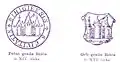 The Seal and Armorial Bearings of Bihać town from the 14th century.
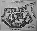 Bihac fortress (Wihitsch), 1686
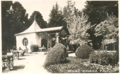 Coffee pavilion in Bihac, ca. 1900
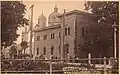 Bihac Orthodox Church and Medresa, ca. 1910
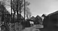 Rural houses in Bihac, ca. 1930
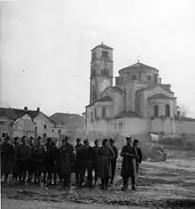 Partisans in Bihać, 1942
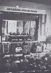 First session of the AVNOJ in Bihać, 1942
Demographics
According to the 2013 census, the city of Bihać has a population of 56,261 inhabitants.
Geography
Climate
| Climate data for Bihać (1961–1990, extremes 1949–present) | |||||||||||||
|---|---|---|---|---|---|---|---|---|---|---|---|---|---|
| Month | Jan | Feb | Mar | Apr | May | Jun | Jul | Aug | Sep | Oct | Nov | Dec | Year |
| Record high °C (°F) | 21.2 (70.2) |
24.2 (75.6) |
27.2 (81.0) |
30.8 (87.4) |
33.7 (92.7) |
38.9 (102.0) |
41.2 (106.2) |
42.0 (107.6) |
36.1 (97.0) |
31.5 (88.7) |
26.6 (79.9) |
21.0 (69.8) |
42.0 (107.6) |
| Average high °C (°F) | 4.0 (39.2) |
6.5 (43.7) |
11.2 (52.2) |
16.3 (61.3) |
21.0 (69.8) |
24.2 (75.6) |
26.7 (80.1) |
26.2 (79.2) |
22.6 (72.7) |
16.9 (62.4) |
10.6 (51.1) |
5.3 (41.5) |
15.9 (60.6) |
| Daily mean °C (°F) | 0.3 (32.5) |
2.3 (36.1) |
6.1 (43.0) |
10.7 (51.3) |
15.1 (59.2) |
18.3 (64.9) |
20.1 (68.2) |
19.3 (66.7) |
15.9 (60.6) |
11.3 (52.3) |
6.3 (43.3) |
1.7 (35.1) |
10.6 (51.1) |
| Average low °C (°F) | −3.7 (25.3) |
−1.7 (28.9) |
1.2 (34.2) |
5.1 (41.2) |
9.1 (48.4) |
12.2 (54.0) |
13.3 (55.9) |
13.0 (55.4) |
10.3 (50.5) |
6.5 (43.7) |
2.3 (36.1) |
−1.9 (28.6) |
5.5 (41.9) |
| Record low °C (°F) | −24.8 (−12.6) |
−29.2 (−20.6) |
−21.0 (−5.8) |
−5.4 (22.3) |
−3.3 (26.1) |
1.4 (34.5) |
4.4 (39.9) |
3.6 (38.5) |
−2.4 (27.7) |
−7.0 (19.4) |
−18.0 (−0.4) |
−18.2 (−0.8) |
−29.2 (−20.6) |
| Average precipitation mm (inches) | 85.8 (3.38) |
90.8 (3.57) |
99.2 (3.91) |
115.0 (4.53) |
116.3 (4.58) |
109.0 (4.29) |
105.9 (4.17) |
109.5 (4.31) |
107.9 (4.25) |
109.6 (4.31) |
146.2 (5.76) |
113.6 (4.47) |
1,308.8 (51.53) |
| Average precipitation days (≥ 0.1 mm) | 13.8 | 14.3 | 14.5 | 14.6 | 14.2 | 14.0 | 10.1 | 10.5 | 10.0 | 12.2 | 14.2 | 15.0 | 157.4 |
| Average snowy days (≥ 1.0 cm) | 16.2 | 13.4 | 8.4 | 1.2 | 0.0 | 0.0 | 0.0 | 0.0 | 0.0 | 0.2 | 5.0 | 13.1 | 57.5 |
| Average relative humidity (%) | 79.8 | 76.7 | 70.6 | 66.7 | 68.9 | 70.5 | 69.3 | 73.1 | 76.5 | 77.6 | 78.9 | 80.6 | 74.1 |
| Mean monthly sunshine hours | 58.3 | 74.0 | 125.4 | 152.1 | 202.1 | 219.7 | 265.6 | 228.2 | 171.6 | 117.4 | 73.2 | 50.3 | 1,737.9 |
| Source: Meteorological Institute of Bosnia and Herzegovina[12][13] | |||||||||||||
Economy
The agricultural sector is significant, due to the large and fertile soil.[14]
Notable people
- Mehmed Alajbegović, politician and lawyer
- Mersada Bećirspahić, basketball player
- Christopher Corvinus (Christopher Hunyadi, 1499–1505), Prince of Hungary and the last male member of the Hungarian Royal House of Hunyadi
- Zlatko Dedić, Slovenian footballer
- Ferid Džanić, World War II Axis soldier (SS Handschar Division)
- Nihad Hasanović, writer and translator
- Alen Islamović, singer, lead vocalist of the bands Divlje Jagode and Bijelo Dugme
- Azra Kolaković, singer
- Zele Lipovača, musician, leading member of Divlje Jagode
- Irfan Ljubijankić, facial surgeon, classical music composer, politician and diplomat of Bosnia and Herzegovina
- Dejan Matić, singer
- Saša Matić, pop singer
- Džanan Musa, basketball player, European U16 champion
- Milan Muškatirović, water polo goalkeeper and professor of organic chemistry
- Saša Radulović, Serbian engineer, politician and former Minister of Economy
- Branka Raunig, archaeologist and museum curator
- Faruk Šehić, poet
- Amir Smajić, folk singer
- Borislav Stanković, Serbian basketball player, coach and secretary General of FIBA
Twin towns – sister cities
Bihać is twinned with:
 Bondeno, Italy[15]
 Kikinda, Serbia[16]
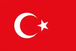 Kuşadası, Turkey[17]
 Nagykanizsa, Hungary[18]
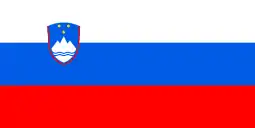 Novo Mesto, Slovenia[19]
 Reșița, Romania[20]
 Villefranche-de-Rouergue, France[21]
See also
- Fethija mosque
- Siege of Bihać
- University of Bihać, opened in 1997
- NK Jedinstvo Bihać, local soccer club
- Željava Air Base
- Bihać Republic
- Una National Park
Notes
- Official results from the book: Ethnic composition of Bosnia-Herzegovina population, by municipalities and settlements, 1991. census, Zavod za statistiku Bosne i Hercegovine - Bilten no.234, Sarajevo 1991.
References
- [http://www.world-gazetteer.com/wg.php?x=&men=gcis&lng=en&des=wg&geo=-27&srt=npan&col=abcdefghinoq&msz=1500&pt=c&va=&srt=pnan World Gazetteer "Archived copy". Archived from the original on 2012-05-15. Retrieved 2012-12-15.CS1 maint: archived copy as title (link) CS1 maint: bot: original URL status unknown (link)
- Mladen Ančić (1985). "Bihaćki kraj od 1262. do početka XV stoljeća". Glasnik arhiva i Društva arhivskih radnika Bosne i Hercegovine (in Serbo-Croatian). Društvo arhivskih radnika Bosne i Hercegovine. pp. 193–230. Retrieved 27 October 2020.
- Franjić, Živko (1999). Povijest Bihaća: od najstarijih vremena do 1878. godine (in Croatian). Napredak. p. 7. Retrieved 27 October 2020.
- Stanić, Damir (5 May 2020). "Bihać kao sjedište Bihaćke kapetanije i slobodni kraljevski grad" (in Croatian). University of Zagreb. University of Zagreb, Faculty of Humanities and Social Sciences. Department of History. Retrieved 27 October 2020.
- Hamdija Kreševljaković. "Stari bosanski gradovi. Vieux bourgs bosniaques" (PDF) (in Bosnian). p. 30. Retrieved 2019-11-11.
- James D. Tracy, 2016, Habsburg Croatia, Ottoman Bosnia, and Venetian Dalmatia, 1499–1617, https://books.google.hr/books?id=KHCPDAAAQBAJ&printsec=frontcover&dq=James+D.+Tracy,+Habsburg+Croatia,+Ottoman+Bosnia,+and+Venetian+Dalmatia,+1499%E2%80%931617&hl=hr&sa=X&ved=0ahUKEwj45ob4tKbmAhXl-ioKHQn0D5gQ6AEIJjAA#v=onepage&q=James%20D.%20Tracy%2C%20Habsburg%20Croatia%2C%20Ottoman%20Bosnia%2C%20and%20Venetian%20Dalmatia%2C%201499%E2%80%931617&f=false #page=113
- Hamdija Kreševljaković. "Stari bosanski gradovi. Vieux bourgs bosniaques" (PDF) (in Bosnian). p. 31. Retrieved 2019-11-11.
- https://library.hungaricana.hu/hu/view/MitKuKKriegsArch_1892_Supplement/?pg=33&layout=s
- "Grad Bihać".
- "Weary Bihac cries with joy as siege ends". The Independent. 9 August 1995. Retrieved 25 January 2010.
- "POPIS STANOVNIŠTVA, DOMAĆINSTAVA I STANOVA U BOSNI I HERCEGOVINI, 2013. REZULTATI POPISA" (PDF). popis2013.ba (in Serbian). Archived from the original (PDF) on 24 December 2017. Retrieved 9 May 2018.
- "Meteorlogical data for station Bihać in period 1961–1990". Meteorological Institute of Bosnia and Herzegovina. Archived from the original on 1 May 2018. Retrieved 30 April 2018.
- "Bihać: Record mensili dal 1949" (in Italian). Meteorological Institute of Bosnia and Herzegovina. Retrieved 10 November 2019.
- Arnautovic, Marija (21 September 2012), Bosnian Town Preserves Coexistence Legacy: Bihać is one of the few places where conflict failed to drive a wedge between communities, TRI Issue 757, Institute for War and Peace Reporting, retrieved 27 December 2015
- "Bihac, gemellaggio che non va ma non per colpa nostra". lanuovaferrara.gelocal.it (in Italian). La Nuova Ferrara. 2016-03-22. Retrieved 2020-12-28.
- "Братски градови". kikinda.org.rs (in Serbian). Kikinda. Retrieved 2020-12-28.
- "Kardeş Şehirler". kusadasi.bel.tr (in Turkish). Kuşadası. Retrieved 2020-12-28.
- "Testvérvárosok". nagykanizsa.hu (in Hungarian). Nagykanizsa. Retrieved 2020-12-28.
- "Mednarodno". novomesto.si (in Slovenian). Mestna občina Novo Mesto. Retrieved 2020-12-28.
- "Orașe înfrățite". primaria-resita.ro (in Romanian). Reșița. Retrieved 2020-12-28.
- "Villefranche-de-Rouergue. Le jumelage avec Sarzana encore bien actif". ladepeche.fr (in French). La Depeche. 2018-09-15. Retrieved 2020-12-28.
External links
| Wikimedia Commons has media related to Bihać. |
Municipalities of the Una-Sana Canton | ||
|---|---|---|