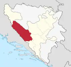
Canton 10
Canton 10 (Croatian: Hercegbosanska županija; Bosnian: Kanton 10; Serbian Cyrillic: Кантон 10) is the largest of the cantons of the Federation of Bosnia and Herzegovina by area and eighth by population. It mainly covers an area of the historical and geographical region of Tropolje. The local government seat is in Livno, while the assembly is in Tomislavgrad.[2]
Canton 10 Hercegbosanska županija Kanton 10 | |
|---|---|
 | |
| Status | Canton of the Federation of Bosnia and Herzegovina |
| Capital | Livno (executive) Tomislavgrad (legislative) |
| Largest city | Livno |
| Official languages | Croatian and Bosnian |
| Ethnic groups (2013[1]) | 77.05% Croats 13.01% Serbs 9.58% Bosniaks |
| Government | Parliamentary system |
| Ivan Vukadin (HNP) | |
| Legislature | Assembly of Canton 10 |
| Canton of the Federation of Bosnia and Herzegovina | |
• Establishment | 12 June 1996 |
| Area | |
• Total | 4,934.9 km2 (1,905.4 sq mi) |
| Population | |
• 2013 census | 83,844 |
| GDP (nominal) | 2019 estimate |
• Total | BAM |
• Per capita | BAM |
| Currency | BAM |
| Time zone | UTC+1 (CET) |
| UTC+2 (CEST) | |
| Date format | dd-mm-yyyy |
| Driving side | right |
Website vladahbz | |
Name, symbols and language
In Croatian, the term županija is used, while in Bosnian and Serbian the term is kanton/кантон. The canton is officially referred by the Federation of Bosnia and Herzegovina as Canton 10 (Kanton 10 or Županija 10).[3] The local government refers to it as the Herzeg-Bosnia County, in Croatian Hercegbosanska županija, and uses that name in the local constitution.[4][5] This name was declared unconstitutional by the Constitutional Court of the Federation because "neither part of the territory of the canton belongs to Herzegovina as a region".[3] Other names used at the national level include North Herzegovina Canton (Sjevernohercegovački kanton, Sjevernohercegovačka županija) and Livno Canton (Livanjski kanton), after its capital.[6][7][8]
The coat of arms of the canton under its constitution is a variant of the historical Croatian coat of arms. The flag is a horizontal tricolour of red, white and blue, with the coat of arms in the middle.[9] These symbols were used by the former Croatian Republic of Herzeg-Bosnia. The West Herzegovina Canton also uses this flag and coat of arms. Their use as the official symbols of the canton was deemed unconstitutional by the Constitutional Court of the Federation, because "they only represented one constituent nation".[3] The local government continues to use the flag and the coat of arms at plates at the official institutions.[10][11]
The constitution lists Croatian and Bosnian languages and the Latin script as official in the canton.[9]
History
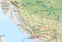
Originally occupied by the Dalmatae, the area of Canton 10 was annexed in 15 AD by the Roman Empire and formed part of the Roman province of Dalmatia. After the introduction of Christianity, Delminium (Tomislavgrad) is the seat of the bishopric.
These years also see the creation of the city of Livno. In 892 was recorder the first written appearance of the name of Livno which was the seat of one of counties of the Kingdom of Croatia. The region is attached in the 9th century to the Kingdom of the Croats and later in the 14th century to the Kingdom of Bosnia. After the death of the king of Bosnia, Tvrtko I in 1391, the power of the Kingdom of Bosnia gradually declines and the region is taken over by the Kingdom of Croatia, the state and associated to the Kingdom of Hungary by a personal union.
In the sixteenth century the region was fully integrated for four centuries within the Ottoman Empire. Under the Ottoman Empire, peasants who remained Catholic or Orthodox were hostile to Turkish officials and to islamized landowners.
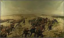
In the nineteenth century, several uprisings and rebellions against Muslim authorities erupted in Bosnia and Herzegovina. Suffering under oppression by the authorities and furious after the Muslim authorities had killed the Catholic spiritual leader of this region, Lovro Karaula, Franciscan priest, the Catholics of Livno rose up against Ottoman rule on July 20, 1875. Soon, the Catholics from across the region joined this uprising. The rebel leaders were two Franciscan priests, Stjepan Krešić and Bonaventura Šarić-Drženjak. For three years, the insurgency controlled the mountainous regions of Glamoč, Livno, Kupres and Grahovo. When the Austrian army arrived in the Livno region in 1878, the insurgents handed over their arms to the Austrians. The Austro-Hungarian troops met in this region an opposition, both of the Muslim population and the Orthodox population, fighting battles in the vicinity of Livno. The region is liberated at the end of the summer of 1878.
Austria-Hungary occupies the region militarily and Bosnia and Herzegovina after the 1878 Berlin Congress. This period is marked by important changes in the region which is industrializing and westernizing. Architecturally, many public buildings were built and many Catholic religious buildings were erected that were banned during the Ottoman era.
The Constitution of the Herzeg-Bosnian Canton was adopted by the Cantonal Assembly on 19 December 1996.
Geography
The total area of the canton is approximately 4,934 square kilometres (1,910 sq mi), a tenth of the surface of Bosnia-Herzegovina and c. 19% of the Federation.[12] The region is located between Dalmatia to the west, Una-Sana Canton to the north, Central Bosnia Canton to the east and West Herzegovina Canton and Herzegovina-Neretva Canton to the south and southeast.
Topography
Mountainous terrain of the region is a part of the Dinaric Alps, linked from a fold and thrust belt dating from the late Jurassic period, itself part of the Alpine orogeny, extending southeast from the southern Alps. The Dinarides form part of a chain of mountains that stretch across southern Europe and isolate Pannonian Basin from the Mediterranean Sea. The highest mountain of the Tropolje Dinarides is Mount Vran, located on the border of the municipalities of Tomislavgrad and Jablanica with the peak called Veliki Vran (Great Vran) at 2,074 metres (6,804 ft).
| Highest mountains of Tropolje | |||
|---|---|---|---|
| Mountain | Peak | Elevation | Coordinates |
| Vran | Veliki Vran | 2,074 m (6,804 ft) | 43°40′4.8″N 17°30′18″E |
| Vran | Mali Vis | 2,014 m (6,608 ft) | 43°40′41.34″N 17°29′57.08″E |
| Cincar | Cincar | 2,006 m (6,581 ft) | 43°54′08″N 17°03′46″E |
| Vran | Crno Brdo | 1,966 m (6,450 ft) | 43°40′52.96″N 17°29′37.3″E |
| Vran | Mali Vran | 1,961 m (6,434 ft) | 43°39′8.8″N 17°17′27″E |
| Vran | Bijela Glava | 1,949 m (6,394 ft) | 43°39′34″N 17°29′56″E |
| Vitorog | Veliki Vitorog | 1,907 m (6,257 ft) | 44°7′12″N 17°2′45″E |
| Golija | Veliki Vrh | 1,886 m (6,188 ft) | 43°59′12″N 16°47′21″E |
| Vran | Priorac | 1,881 m (6,171 ft) | 43°39′37″N 17°28′27″E |
| Šator | Veliki Šator | 1,872 m (6,142 ft) | 44°9′26″N 13°35′23″E |
Political subdivisions
.png.webp)
Canton 10 includes 6 municipalities: Drvar, Bosansko Grahovo, Glamoč, Kupres, Livno and Tomislavgrad.
| Coat of arms | Municipality | Population[13] | Area (km2)[13] |
|---|---|---|---|
| Bosansko Grahovo | 3,091 | 780.0 | |
| Drvar | 7,506 | 589.3 | |
| Glamoč | 4,038 | 1033.6 | |
| Kupres | 5,573 | 569.8 | |
| Livno | 37,487 | 994.0 | |
| Tomislavgrad | 33,032 | 967.4 |
Governance
The canton is governed by the Government of Canton 10 (Croatian: Vlada Hercegbosanske županije; Bosnian: Vlada Kantona 10; Serbian Cyrillic: Влада Кантона 10). The current government is a coalition of 2 parties led by Croatian Democratic Union. The current Prime Minister is Ivan Jozić.[14]
Cantonal Assembly

The Cantonal Assembly (Croatian: Županijska skupština, Bosnian and Serbian: Kantonalna skupština/Кантонална скупштина) is the parliament of the Canton 10. It consists of 25 representatives elected by proportional representation for four-year terms of office.
| Political party | Assembly members | |||||||||
|---|---|---|---|---|---|---|---|---|---|---|
| 2002 | 2006 | 2010 | 2014 | 2018 | currently | |||||
| Croatian National Shift (HNP) | - | - | - | - | - | 6 / 25 | ||||
| Croatian Democratic Union (HDZ 1990) | - | 6 | 4 | 4 | 4 | 4 / 25 | ||||
| Alliance of Independent Social Democrats (SNSD) | 3 | 5 | 3 | 3 | 3 | 3 / 25 | ||||
| Croatian Independent List (HNL) | - | - | - | 2 | 3 | 3 / 25 | ||||
| Croatian Democratic Union (HDZ BiH) | 13 | 5 | 9 | 9 | 8 | 2 / 25 | ||||
| Party of Democratic Action (SDA) | 2 | 2 | 2 | 2 | 2 | 2 / 25 | ||||
| Serbian Progressive Party (SNS) | - | - | - | - | 1 | 1 / 25 | ||||
| People's Party For Work And Betterment (NSRzB) | 2 | 1 | 3 | 2 | 1 | 1 / 25 | ||||
| Cantonal Independent List (ŽNL) | - | - | - | - | 1 | 1 / 25 | ||||
| Croatian Republican Party (HRS) | - | - | - | - | 1 | 1 / 25 | ||||
| Social Democratic Party (SDP BiH) | 1 | 1 | 1 | 1 | 1 | 1 / 25 | ||||
| Sources:[15][16][17][18] | ||||||||||
Demographics
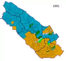
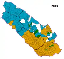
According to the 1991 census, 115.682 people inhabited the canton. Croats comprised 51.5%, Serbs comprised 35.7% and Bosnian Muslims comprised 10.4% of the population. Croats overwhelmingly lived in the southeastern part of the canton (Livno, Kupres, Tomislavgrad), while Serbs lived in northwestern (Grahovo, Glamoč, Drvar). There was a significant population migration during the war (1992–95). In 1992, Serb forces captured Kupres and the surrounding area, pushing away most of the non-Serb population. Croats returned at the end of 1994, after their forces have retaken Kupres. After Croat forces captured Grahovo, Glamoč and Drvar in the summer and fall of 1995, most of the Serb population fled. Refugee Croats from other parts of Bosnia and Herzegovina (fleeing Serb or Bosniak forces) settled in the abandoned area previously inhabited by the Serbs. After the war, under UN and peace implementation forces' pressure, Serb refugees returned to their homes.
In 2013, Canton's population included approximately 77% Croats, 13% Serbs and 9.6% Bosniaks; all other ethnicities combined made up the remaining <0.4%. Canton 10 had the largest share of ethnic Serbs in the Federation of Bosnia and Herzegovina. However, their number has steadily decreased since the conclusion of the Bosnian War.
1991 Census
| Municipality | Nationality | Total | |||||||
|---|---|---|---|---|---|---|---|---|---|
Croats |
% |
Serbs |
% |
Muslims |
% |
Other |
% | ||
| Livno | 29,324 | 72.22 | 3,913 | 9.63 | 5,793 | 14.26 | 1,570 | 3.87 | 40,600 |
| Tomislavgrad | 25,976 | 86.56 | 576 | 1.91 | 3,148 | 10.49 | 309 | 1.02 | 30,009 |
| Glamoč | 184 | 1.46 | 9,951 | 79.02 | 2,257 | 17.92 | 201 | 1.58 | 12,593 |
| Kupres | 3,812 | 43.19 | 4,081 | 46.23 | 802 | 9.08 | 131 | 1.47 | 8,826 |
| Bosansko Grahovo | 226 | 2.71 | 7,888 | 94.91 | 12 | 0.14 | 185 | 2.22 | 8,311 |
| Drvar | 31 | 0.20 | 14,846 | 96.76 | 29 | 0.18 | 437 | 2.86 | 15,343 |
| Canton | 59,553 | 51.48 | 41,255 | 35.66 | 12,041 | 10.41 | 2,833 | 2.45 | 115,682 |
2013 Census
| Municipality | Nationality | Total | |||||||
|---|---|---|---|---|---|---|---|---|---|
Croats |
% |
Serbs |
% |
Bosniaks |
% |
Other |
% | ||
| Livno | 29,273 | 85.76 | 438 | 1.28 | 4,047 | 11.85 | 216 | 0.63 | 34,133 |
| Tomislavgrad | 29,006 | 91.81 | 22 | 0.06 | 2,467 | 7.80 | 30 | 0.09 | 31,592 |
| Glamoč | 906 | 23.47 | 1,679 | 43.49 | 1,251 | 32.40 | 13 | 0.33 | 3,860 |
| Kupres | 4,474 | 88.47 | 318 | 6.28 | 255 | 5.04 | 5 | 0.09 | 5,057 |
| Bosansko Grahovo | 393 | 16.04 | 2,028 | 82.80 | 6 | 0.24 | 10 | 0.40 | 2,449 |
| Drvar | 552 | 7.08 | 6,420 | 91.24 | 11 | 0.15 | 24 | 0.34 | 7,036 |
| Canton | 64,604 | 77.05 | 10,905 | 13.01 | 8,037 | 9.58 | 298 | 0.36 | 83,844 |
Economy
_Touristic_Map.png.webp)
The canton has significant natural resources, with large reserves of coal and timber, as well as hydro & wind power. Due to economic reasons (insufficient canton revenues compared to expenses) unification with West Herzegovina Canton has been proposed.[19][20]
References
- Sarajevo, juni 2016. CENZUS OF POPULATION, HOUSEHOLDS AND DWELLINGS IN BOSNIA AND HERZEGOVINA, 2013 FINAL RESULTS (PDF). BHAS. Archived from the original (PDF) on 24 December 2017. Retrieved 30 June 2016.
- www.skupstinahbz.com. "Skupština Hercegbosanske županije". www.skupstinahbz.com. Retrieved 6 April 2018.
- "U-11/97". Archived from the original on 2008-04-19. Retrieved 2009-06-08.CS1 maint: bot: original URL status unknown (link)
- "hbzup.com". www.hbzup.com. Archived from the original on 2007-07-16. Retrieved 6 April 2018.
- "Vlada Hercegbosanske županije". www.vladahbz.com. Retrieved 6 April 2018.
- "Utopio se pijan plivajući u Buškom jezeru". sarajevo-x.com. Retrieved 6 April 2018.
- "mediainfo.ba - Livanjski kanton: Do 2010. godine biće izgrađene prve vjetrenjače". mediainfo.ba. Archived from the original on 2009-02-01. Retrieved 6 April 2018.
- "24sata.info - Livanjski kanton: Ministar zdravlja Darko Horvat lomio po kafani!". 24sata.info. Archived from the original on 2011-07-28. Retrieved 6 April 2018.
- "Ustav - Vlada Hercegbosanske županije" (PDF). Vlada Hercegbosanske županije. 12 October 2005. p. 3.
- "Naslovna - Ministarstvo unutranjih poslova Kantona 10". www.mupk10.gov.ba (in Croatian and Bosnian). Ministarstvo unutarnjih poslova K10. Retrieved 19 July 2018.
- "Sporna obilježja na grbovima BiH". Al Jazeera Balkans. 23 April 2015.
- "Archived copy". Archived from the original on 2010-05-13. Retrieved 2009-11-08.CS1 maint: archived copy as title (link)
- (in Bosnian and Croatian) "PRELIMINARY RESULTS Of the 2013 Census of Population, Households and Dwellings in Bosnia and Herzegovina" (PDF). www.bhas.ba/. Agency for Statistics of Bosnia and Herzegovina. 5 November 2013. Archived from the original (PDF) on 23 November 2018. Retrieved 28 January 2014.
- "Government of Canton 10". vladahbz.com (in Croatian). Government of Canton 10. Retrieved 22 December 2020.
- "Verified results of the 2010 general elections: The Cantonal Assemblies in the Federation of Bosnia and Herzegovina: Canton 10". izbori.ba. Central Election Commission of Bosnia and Herzegovina. Archived from the original on 5 November 2010. Retrieved 30 May 2013.
- "210-Skupština kantona 10 (210-Assembly of Canton 10)". izbori.ba (in Bosnian). Central Election Commission of Bosnia and Herzegovina. Retrieved 30 May 2013.
- "Opći izbori-konačni rezultati (General elections-final results)" (PDF). izbori.ba (in Croatian). Central Election Commission of Bosnia and Herzegovina. Retrieved 30 May 2013.
- "Opći izbori-konačni rezultati (General elections-final results)". izbori.ba. Central Election Commission of Bosnia and Herzegovina. Retrieved 24 October 2018.
- "Archived copy". Archived from the original on 2011-07-06. Retrieved 2009-07-28.CS1 maint: archived copy as title (link)
- Monitor - portal za svaki dan - Offline
External links
| Wikimedia Commons has media related to Canton 10. |