Bilborough
Bilborough is a suburb of the city of Nottingham, England. The population of the City of Nottingham ward at the 2011 census was 16,792.[1]
| Bilborough | |
|---|---|
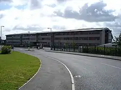
 Bilborough College | |
 Bilborough Location within Nottinghamshire | |
| Population | 16,792 (ward. 2011) |
| OS grid reference | SK 51845 41162 |
| District | |
| Shire county | |
| Region | |
| Country | England |
| Sovereign state | United Kingdom |
| Post town | NOTTINGHAM |
| Postcode district | NG8 |
| Dialling code | 0115 |
| Police | Nottinghamshire |
| Fire | Nottinghamshire |
| Ambulance | East Midlands |
| UK Parliament | |
Located just off the A6002 road is Bilborough College.
Bilborough has a high street called Bracebridge Drive containing a bank (Lloyds TSB), a butcher's shop, a Gregg's, a library, Health Centre, Boots the Chemists, Hardware Store, Andys Fish & Chip Shop, Post Office, H K Baxter General Store, Co-op store, Heron Foods and two charity shops (Sue Ryder and Salvation Army). Bracebridge Drive also has a local pub, The Pelican. Opposite this is a garage which specialises in tyres and car washes.
Education
Bilborough is home to the following schools and colleges:
- Nottingham University Samworth Academy (NUSA), and also is home to Portland, Melbury, Highwood which are all feeders to (NUSA)
- Bilborough College, which ranks highly in the country.
- Oak Field School
- Bluecoat Beechdale Academy
- Westbury School primary and secondary
- Bluecoat Primary Academy
Sports
Harvey Hadden Stadium is a well known local sport facility with outdoor running track and athletics facilities. The stadium originally had a velodrome.
Bus services
■ 28: Nottingham → Ilkeston Road → Jubilee Campus → Beechdale → Bilborough[2]
■ 35: Nottingham → Derby Road → QMC → University Park → Wollaton Vale → Bilborough → Strelley → Bulwell[3]
■ 35B: Nottingham → Derby Road → QMC → University Park → Wollaton Vale → Bilborough → Strelley[4]
■ N28: Nottingham → Jubilee Campus → Beechdale → Bilborough → Wollaton Vale → Wollaton → Ilkeston Road → Nottingham[5]
- Nottingham Community Transport
■ L3: Nottingham → Derby Road → QMC → Beechdale → Bilborough → Strelley[6]
■ L11: Beeston → Wollaton Vale → Bilborough → Aspley Lane → Basford → Bulwell → Top Valley → Bestwood Park → Arnold[7]
■ Collegelink: Nottingham → Bilborough (Bilborough College)[8]
References
- "City of Nottingham ward population 2011". Neighbourhood Statistics. Office for National Statistics. Retrieved 18 April 2016.
- wearebase.com, Base. "Service 28 on Pink Line". nctx.co.uk. Archived from the original on 15 October 2017. Retrieved 14 October 2017.
- wearebase.com, Base. "Service 35 on Orange Line". nctx.co.uk. Archived from the original on 15 March 2018. Retrieved 14 October 2017.
- wearebase.com, Base. "Service 35B on Orange Line". nctx.co.uk. Archived from the original on 15 October 2017. Retrieved 14 October 2017.
- wearebase.com, Base. "Service N28 on Pink Line". nctx.co.uk.
- wearebase.com, Base. "Locallink service L3 ran by Nottingham Community Transport" (PDF). ct4n.co.uk.
- wearebase.com, Base. "Locallink service L3 ran by Nottingham Community Transport" (PDF). ct4n.co.uk.
- wearebase.com, Base. "Collegelink ran by Bilborough College" (PDF). bilborough.ac.uk.