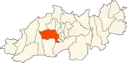
Blida
Blida (Arabic: البليدة; Tamazight: Leblida) is a city in Algeria. It is the capital of Blida Province, and it is located about 45 km south-west of Algiers, the national capital.[1] The name Blida, i.e. bulaydah, diminutive of the Arabic word belda, city.
Blida
البليدة (in Arabic) | |
|---|---|
%252C_Place_Toute.jpg.webp) .jpg.webp) 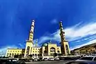 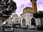 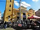 Overview of Blida | |
.svg.png.webp) Seal | |
| Nicknames: City of roses, مدينة الورود | |
 Location of Blida, Algeria within Blida Province | |
 Blida Location of Blida, Algeria within Blida Province | |
| Coordinates: 36°28′07″N 02°49′55″E | |
| Country | |
| Province | Blida Province |
| District | Blida District |
| Area | |
| • City | 72.1 km2 (27.8 sq mi) |
| Elevation | 260 m (850 ft) |
| Population (2012) | |
| • City | 182,447 |
| • Density | 2,500/km2 (6,600/sq mi) |
| • Metro | 1,167,882 |
| Time zone | UTC+1 (CET) |
| Postal code | 09000 |
| Area code(s) | 901 |
| Climate | Csa |
Geography and natural features
Blida is known as the city of roses because of the large number of roses in its gardens.
Blida lies surrounded with orchards and gardens, 190 metres (620 ft) above the sea, at the base of the Tell Atlas, on the southern edge of the fertile Mitidja Plain, and the right bank of the Oued el kebir outflow from the Chiffa gorge. The abundant water of this stream provides power for large corn mills and several factories, and also supplies the town, with its numerous fountains and irrigated gardens. Blida is surrounded by a wall of considerable extent, pierced by six gates, and is further defended by Port Mimieh, crowning a steep hill on the left bank of the river.[2]
The nearby Chiffa gorge is a habitat of the endangered Barbary macaque, Macaca sylvanus; this habitat is one of only a few relict locations where populations of this primate are found.[3]
Climate
In Blida, there is a Mediterranean climate. In winter there is more rainfall than in summer. The Köppen-Geiger climate classification is Csa. The average annual temperature in Blida is 17.9 °C (64.2 °F). About 791 mm (31.14 in) of precipitation falls annually.
| Climate data for Blida | |||||||||||||
|---|---|---|---|---|---|---|---|---|---|---|---|---|---|
| Month | Jan | Feb | Mar | Apr | May | Jun | Jul | Aug | Sep | Oct | Nov | Dec | Year |
| Average high °C (°F) | 14.2 (57.6) |
15.5 (59.9) |
17.3 (63.1) |
19.9 (67.8) |
23.3 (73.9) |
26.8 (80.2) |
30.9 (87.6) |
31.7 (89.1) |
28.2 (82.8) |
23.3 (73.9) |
18.5 (65.3) |
15.3 (59.5) |
22.1 (71.7) |
| Average low °C (°F) | 7.0 (44.6) |
7.6 (45.7) |
9.3 (48.7) |
11.4 (52.5) |
14.3 (57.7) |
17.7 (63.9) |
21.4 (70.5) |
22.1 (71.8) |
20.0 (68.0) |
15.2 (59.4) |
10.9 (51.6) |
8.2 (46.8) |
13.8 (56.8) |
| Average precipitation mm (inches) | 116 (4.6) |
85 (3.3) |
92 (3.6) |
64 (2.5) |
58 (2.3) |
26 (1.0) |
2 (0.1) |
4 (0.2) |
34 (1.3) |
66 (2.6) |
114 (4.5) |
130 (5.1) |
791 (31.1) |
| Source: climate-data | |||||||||||||
History
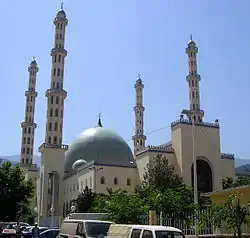
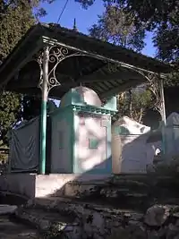
The present town, French in character, has well-built modern streets with many arcades, and numbers among its buildings several mosques and churches, extensive barracks and a large military hospital. The principal square, the place d'Armes, is surrounded by arcaded houses and shaded by trees. The center of a fertile district, and a post on one of the main routes in the country, Blida has a flourishing trade, chiefly in oranges and flour. The orange groves contain over 50,000 trees, and in April the air for miles round is laden with the scent of the orange blossoms. In the public gardens is a group of magnificent olive trees. The products of the neighboring cork trees and cedar groves are a source of revenue to the town.[4][2] Sidi-Ahmed El-Kebir, Blida's founder, is buried in Sidi El-Kebir (an area named after him). He founded Blida in the 16th century.
The city occupies the site of a military station in the time of the Romans, but the present town appears to date from the 16th century,[2] in which it was founded, according to Baedeker, by Moors.[4] A mosque was built by order of Khair-ed-din Barbarossa, and under the Turks the town was of some importance. In 1825 it was nearly destroyed by an earthquake,[4] but was speedily re-erected on a site about a mile distant from the ruins.[2] It was intricately rebuilt of interconnecting alleyways and streets, and was made accessible through the existing six major gates. The gates were as follows:
- Bab Er-Rahba
- Bab Ed-Zair
- Bab El-Khouikha
- Bab Es-Sebt
- Bab Ez-Zaouia
- Bab El-Kbour
- beb el-kseb
Today those gates no longer exist, but their names are still in use by people in Blida as reference points to locate streets, places, schools and businesses.
In 1867, another earthquake damaged Blida.[4]
Blida Province is home to a number of Berber-speaking tribes &towns. The Berbers of blida are known as Djebailia and have been in the plains of Blida/Matija for thousands of years according to historians such as Ibn khaldoun. The tribes are Beni Salah(Ith salah)Beni Misrah(Ith Misra), Ghalia and many more. Their Amazigh dialect (Tachelhit) is related to the Tamazight of Atlas Mountains. Blida Berber language (Tachelhit) is perticulaly close to the Kabyle varieties spoken east of Algiers Province, It's 95% identical and has traditionally been seen as an intermediate between Kabyle and the Chenoua language native to the north-eastern part of the country.
Notable people
- Elissa Rhaïs, novelist
Notes
- Alice Cherki and Nadia Benabid, 2006
-
 One or more of the preceding sentences incorporates text from a publication now in the public domain: Chisholm, Hugh, ed. (1911). "Blida". Encyclopædia Britannica. 4 (11th ed.). Cambridge University Press. pp. 58–59.
 - C. Michael Hogan, 2008
- "Arab Market, Blida, Algeria". World Digital Library. 1899. Retrieved 25 September 2013.
References
| Wikimedia Commons has media related to Blida. |
- Alice Cherki and Nadia Benabid (2006) Frantz Fanon: A Portrait, Cornell University Press, 255 pages ISBN 0-8014-7308-X
- C. Michael Hogan, (2008) Barbary Macaque: Macaca sylvanus, Globaltwitcher.com, ed. Nicklas Stromberg
| Blida District | .svg.png.webp) | |
|---|---|---|
| Boufarik District | ||
| El Affroun District | ||
| Larbaâ District | ||
| Ouled Yaïch District | ||
| Bouinan District | ||
| Bougara District | ||
| Oued El Alleug District | ||
| Mouzaïa District | ||
| Meftah District | ||