El Bayadh
El Bayadh (Arabic: البيض) is a municipality of Algeria. It is the capital of El Bayadh Province. This town was known as Géryville during the French colonization of Algeria.
El Bayadh
البيض | |
|---|---|
| City of El Bayadh | |
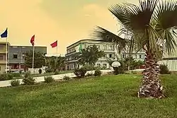 | |
 Location of El Bayadh, Algeria within El Bayadh Province | |
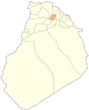
 El Bayadh Location of El Bayadh within Algeria | |
| Coordinates: 33°40′49″N 1°01′13″E | |
| Country | |
| Province | El Bayadh |
| District | El Bayadh District |
| Government | |
| • PMA Seats | 11 |
| Area | |
| • Total | 497 km2 (192 sq mi) |
| Elevation | 1,347 m (4,419 ft) |
| Population (2008 Census) | |
| • Total | 85,577 |
| • Density | 170/km2 (450/sq mi) |
| Time zone | UTC+01 (CET) |
| Postal code | 32000 |
| ONS code | 3201 |
| Climate | BWk |
Geography
The Ksour Range is a mountainous area extending between Figuig and El Bayadh.[2]
| Climate data for El Bayadh | |||||||||||||
|---|---|---|---|---|---|---|---|---|---|---|---|---|---|
| Month | Jan | Feb | Mar | Apr | May | Jun | Jul | Aug | Sep | Oct | Nov | Dec | Year |
| Record high °C (°F) | — | — | — | — | — | — | — | — | 51.3 (124.3) |
— | — | — | 51.3 (124.3) |
| Source: [3] | |||||||||||||
References
- "Mundomanz.com - Datos". www.mundomanz.com.
- "GÉOGRAPHIE MILITAIRE - LIVRE VI - ALGÉRIE et TUNISIE par le colonel NIOX - 2ème édition". aj.garcia.free.fr.
- "Seconde Communication Nationale de L'Algerie Sur Les Changements Climatiques a la CCNUCC" (PDF) (in French). Ministere de L'Amenagement du Territoire et de L'Environnement. 2010. p. 27. Retrieved 23 October 2016.
| Chellala District | .svg.png.webp) | |
|---|---|---|
| Brézina District | ||
| Rogassa District | ||
| El Abiodh Sidi Cheikh District | ||
| Boualem District | ||
| Bougtob District | ||
| El Bayadh District | ||
| Boussemghoun District | ||
| Wikimedia Commons has media related to El Bayadh. |
This article is issued from Wikipedia. The text is licensed under Creative Commons - Attribution - Sharealike. Additional terms may apply for the media files.
