Borders of France
The borders of France are the international borders that the French Republic shares with neighbouring sovereign states. France has borders with 11 countries, totaling 4,176 kilometres (2,595 mi) for all of France and 2,913 kilometres (1,810 mi) for Metropolitan France.[1]
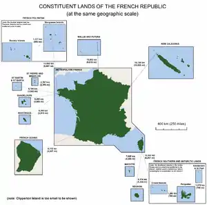
France and its territories
In June 2015, Italian Prime Minister Matteo Renzi expressed repeated claims on some of the highest peaks of the Mont Blanc Massif territory: Dôme du Goûter, Pointe Helbronner (Punta Helbronner) and the tallest, Mont Blanc (Monte Bianco) itself.[2]
List
The lengths of the borders France shares with different countries are listed below. Maritime borders, such as Canada, are not all included. [1]
Metropolitan France
- Eastern border
| Country | Length | Bordering regions | Border features | Border crossings |
|---|---|---|---|---|
| 652–659 km 405.13–409.48 mi |
Hauts-de-France Grand Est |
|||
| 73 km 45.36 mi |
Grand Est | |||
| 448 km 278.37 mi |
Grand Est | |||
| 573 km 356.05 mi |
Bourgogne-Franche-Comté Auvergne-Rhône-Alpes Grand Est |
|||
| 515 km 320.01 mi |
Auvergne-Rhône-Alpes Provence-Alpes-Côte d'Azur |
|||
| 4 km 2.49 mi |
Provence-Alpes-Côte d'Azur | |||
| Total | 2,233 km 1,387.52 mi |
|||
- Southwestern border
| Country | Length | Bordering regions | Border features | Border crossings |
|---|---|---|---|---|
| 623 km 387.11 mi |
Nouvelle-Aquitaine, Occitanie | |||
| 57 km 35.42 mi |
Occitanie | |||
| Total | 680 km 422.53 mi |
|||
Overseas France
| Country | Length | Bordering department | Border features | Border crossings |
|---|---|---|---|---|
| 13 km 8.08 mi |
Saint Martin | |||
| 520 km 323.11 mi |
French Guiana | |||
| 730 km 453.60 mi |
French Guiana[3] | |||
| Total | 1,263 km 784.79 mi |
|||
References
This article is issued from Wikipedia. The text is licensed under Creative Commons - Attribution - Sharealike. Additional terms may apply for the media files.