Bourdalat
Bourdalat is a commune in the Landes department in Nouvelle-Aquitaine in southwestern France.
Bourdalat | |
|---|---|
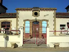 Town hall | |
Location of Bourdalat 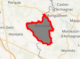
| |
 Bourdalat  Bourdalat | |
| Coordinates: 43°50′25″N 0°12′31″W | |
| Country | France |
| Region | Nouvelle-Aquitaine |
| Department | Landes |
| Arrondissement | Mont-de-Marsan |
| Canton | Adour Armagnac |
| Intercommunality | Pays de Villeneuve en Armagnac Landais |
| Government | |
| • Mayor (2020–2026) | Éric Darquier |
| Area 1 | 14.15 km2 (5.46 sq mi) |
| Population (2017-01-01)[1] | 252 |
| • Density | 18/km2 (46/sq mi) |
| Time zone | UTC+01:00 (CET) |
| • Summer (DST) | UTC+02:00 (CEST) |
| INSEE/Postal code | 40052 /40190 |
| Elevation | 76–135 m (249–443 ft) (avg. 110 m or 360 ft) |
| 1 French Land Register data, which excludes lakes, ponds, glaciers > 1 km2 (0.386 sq mi or 247 acres) and river estuaries. | |
Geography
The commune of Bourdalat is located at the eastern end of the Landes department, near the Gers, and in the heart of the Bas-Armagnac, the most famous area of the appellation of the same name.
Hydrography
The stream of the Gaube, a tributary of the Midou , waters the lands of the commune. Lake Charros is located in the northeast end of the commune.
Population
| Year | Pop. | ±% |
|---|---|---|
| 1962 | 267 | — |
| 1968 | 272 | +1.9% |
| 1975 | 252 | −7.4% |
| 1982 | 215 | −14.7% |
| 1990 | 186 | −13.5% |
| 1999 | 187 | +0.5% |
| 2006 | 212 | +13.4% |
| 2013 | 225 | +6.1% |
_dans_son_Arrondissement.png.webp)
Location of the commune of Bourdalat in the arrondissement of Mont-de-Marsan (Landes)
See also
References
- "Populations légales 2017". INSEE. Retrieved 6 January 2020.
| Wikimedia Commons has media related to Bourdalat. |
| Authority control |
|---|
This article is issued from Wikipedia. The text is licensed under Creative Commons - Attribution - Sharealike. Additional terms may apply for the media files.