Hastingues
Hastingues (Occitan: Hastings, Basque: Hastinga) is a commune in the Landes department in Nouvelle-Aquitaine in southwestern France. Its nickname, due to its location on a rounded-shaped hill, is lou Carcolh (the snail).
Hastingues | |
|---|---|
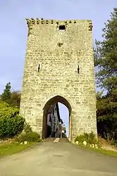 Gate of Hastingues from the 14th century | |
Location of Hastingues 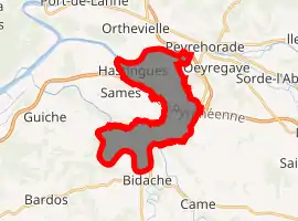
| |
 Hastingues  Hastingues | |
| Coordinates: 43°32′07″N 1°08′52″W | |
| Country | France |
| Region | Nouvelle-Aquitaine |
| Department | Landes |
| Arrondissement | Dax |
| Canton | Orthe et Arrigans |
| Intercommunality | Pays d'Orthe |
| Government | |
| • Mayor (2014–2020) | Pierre Ducarre |
| Area 1 | 14.54 km2 (5.61 sq mi) |
| Population (2017-01-01)[1] | 579 |
| • Density | 40/km2 (100/sq mi) |
| Time zone | UTC+01:00 (CET) |
| • Summer (DST) | UTC+02:00 (CEST) |
| INSEE/Postal code | 40120 /40300 |
| Elevation | 0–84 m (0–276 ft) (avg. 44 m or 144 ft) |
| 1 French Land Register data, which excludes lakes, ponds, glaciers > 1 km2 (0.386 sq mi or 247 acres) and river estuaries. | |
Geography
The town lies on a hill looking over the valley of the Gaves réunis, in the Gascon region and bordering on the Basque Country.
History
The bastide was founded in 1289 by John Hastings, seneschal of Gascony, who signed a treaty of coregency in the name of Edward I of England between the king, Duke of Aquitaine and the monks of Arthous abbey.
The work on the gate was started in 1289, but the town wall still was not complete in the 15th century.
The houses of Jurats and Sénéchal were built in the same century.
Population
| Year | Pop. | ±% |
|---|---|---|
| 1793 | 900 | — |
| 1806 | 850 | −5.6% |
| 1821 | 850 | +0.0% |
| 1831 | 901 | +6.0% |
| 1841 | 942 | +4.6% |
| 1851 | 914 | −3.0% |
| 1861 | 850 | −7.0% |
| 1872 | 800 | −5.9% |
| 1881 | 755 | −5.6% |
| 1891 | 716 | −5.2% |
| 1901 | 690 | −3.6% |
| 1911 | 656 | −4.9% |
| 1921 | 541 | −17.5% |
| 1931 | 444 | −17.9% |
| 1946 | 441 | −0.7% |
| 1954 | 445 | +0.9% |
| 1962 | 417 | −6.3% |
| 1968 | 401 | −3.8% |
| 1975 | 408 | +1.7% |
| 1982 | 447 | +9.6% |
| 1990 | 472 | +5.6% |
| 1999 | 447 | −5.3% |
| 2008 | 559 | +25.1% |
| 2013 | 591 | +5.7% |
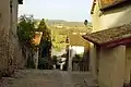 View from the town over the valley and the river
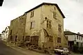 Maison Jurats
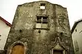 House of the Seneschal
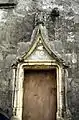 Entrance of the house of the Seneschal
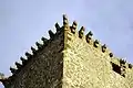 Detail of the gate
See also
| Wikimedia Commons has media related to Hastingues. |
| Authority control |
|
|---|
This article is issued from Wikipedia. The text is licensed under Creative Commons - Attribution - Sharealike. Additional terms may apply for the media files.