Bozcaada, Çanakkale
Bozcaada is an Aegean island, municipality, and district governorate in Çanakkale Province, Turkey.
Bozcaada | |
|---|---|
Island, District | |
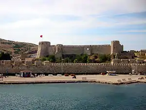 Bozcaada Castle in the district center | |
 Bozcaada Location in Turkey | |
| Coordinates: 39°50′N 26°04′E | |
| Country | |
| Province | Çanakkale Province |
| Government | |
| • Body | District Municipality |
| • Governor *Mayor | Mustafa AKIN Dr. Hakan Can YILMAZ (CHP) |
| Elevation | 5 m (15 ft) |
| Population (2018) | |
| • Total | 3,023 |
| Time zone | UTC+2 (EET) |
| • Summer (DST) | UTC+3 (EEST) |
| Postal code | 17680 |
| Area code(s) | 0286 |
| Licence plate | 17 |
Geography
Bozcaada district covers the Bozcaada island and a total of 17 islets around the main island. The total area of the district (including the islets ) is 36.7 square kilometres (14.2 sq mi). The highest point of the district is Göztepe with an altitude of 192 metres (630 ft).[1] The district center is situated on the east side of the island at about 39°50′N 26°04′E. It is situated 22 km. (12 Nautical miles) south of Dardanelles Strait (Çanakkale Boğazı) Its distance to Geyikli the nearest sea port on the main land (Anatolia) is 7.5 km ( 4.5 nautical miles). The distance from Geyikli to Çanakkale (province center) is about 40 kilometres (25 mi). Up until recently, Bozcaada was unique in Turkey as being a district with no rural population. (Because of metropolitan municipalities established after the 1980s there are now some other districts with no rural population.) Its population (all in the district center) is 3023 as of 2018.[2] In 2012 it was 2465[3] and in 2010 it was 2354.[4]
History
.jpg.webp)
In the antiquity the island was known as Leukophrys and in Greek mythology it was Tenedos. It was mentioned in Homer's Iliad. In the medieval age it was a Byzantine possession. Towards the end of the medieval age it was left to Republic of Venice by the emperor John V Palaiologos as a ransom. In 1381 however, following Venetian Genoese War it was evacuated by the Venetians according to the Peace of Turin.[5] In 1455 it was annexed by the Ottoman Empire during the reign of Mehmet II. Although the Venetians tried to regain the island, in 1464 the Ottoman control was secured by Mahmut Pasha. As a result of the former evacuation, the island was uninhabited during the early years of Ottoman administration and the Ottoman Empire populated the present Bozcaada district by using tax exemption. Ottoman Empire also restored the castle which was demolished during the Venetian-Genoese war.[6] Turks called the island Bozcaada meaning grayish island and the famous cartographer Piri Reis of the 16th century also used this name in his maps. In 1923 when the Turkish Republic was proclaimed, the island was declared a district and the only settlement in Bozcaada became the municipality and district center of Çanakkale Province.
Economy
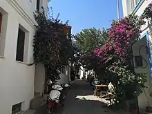

The major economic activities of Bozcaada are tourism, wineries, and fishing, with tourism as the dominant ecnomic sector. More than 1.5 million tourists visited Bozccaada in 2018, driven in part by an increased presence in the global media.[7][8]
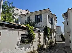
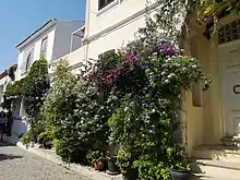
Places of interest
According to municipality of Bozcaada the historically important buildings are the following[9]
- Bozcaada castle which was reconstructed by the Ottoman sultan Mehmet II in the 15th century, and repaired by the Ottoman sultan Mahmut II in 1815 is the most important touristic attraction of Bozcaada. It is in the district center facing east. Thus visitors to Bozcaada can observe the castle during their voyage.
- Another castle is a casemate which is popularly called Yenikale ("new castle"). Despite its name it is in ruins. It was constructed in 1827 by Hafız Ali Pasha, the governor of Bozcaada. It is situated on a hill to the west of Bozacaada district center
- Alaybey mosque was probably built in 1700 by Ahmet Ağa, the governor of Bozcaada. It is partially in ruins.
- Yalı camii is a mosque which was built on the foundations of a medieval Venetian building in 1655. It was commissioned by Köprülü Mehmet Pasha (future grand vizier) in 1655. It is now under restoration.
- Namazgah fountain (with cistern) was built in 1703.
- Kimisis Teodoku (St Mary) church was built in 1869.
- The monastery of Aya Paraskevi
Sister cities
 Valu lui Traian, Romania
 Gols, Austria
References
- Çanakkale mekan page (in Turkish)
- "Nüfus Durumu". 26 December 2020.
- Statistical Institute 2012 Archived November 29, 2014, at the Wayback Machine
- Statistical Institute 2010 Archived January 10, 2014, at the Wayback Machine
- Nicolae Jorga: Geschichte des Osmanischen Vol I, translated by Nilüfer Epçeli, Yeditepe, yayınları, istanbul, 2009 ISBN 975-6480-18-1, p. 236
- Prof. Yaşar Yüce-Prof. Ali Sevim: Türkiye tarihi Cilt II, AKDTYKTTK Yayınları, İstanbul, 1991 pp. 248–249
- "A Secret Aegean Island Paradise: Bozcaada". Forbes. Retrieved 3 December 2020.
- "52 Places to Go in 2017". New York Times. Retrieved 3 December 2020.
- Mayor's page Archived August 4, 2013, at the Wayback Machine
| Wikimedia Commons has media related to Bozcaada. |
External links
Bozcaada, Çanakkale in Çanakkale Province of Turkey | |||||||||||||||||||||||||||
|---|---|---|---|---|---|---|---|---|---|---|---|---|---|---|---|---|---|---|---|---|---|---|---|---|---|---|---|
| Districts | 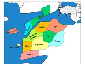 Districts of Çanakkale | ||||||||||||||||||||||||||
| |||||||||||||||||||||||||||
Metropolitan municipalities are bolded. | |||||||||||||||||||||||||||