Bayburt Province
Bayburt Province (Turkish: Bayburt ili) is a province of Turkey. Located in the Northeast Anatolia region of the country, the capital city is Bayburt, and with a population of 74,412 is the least-populous province in Turkey.
Bayburt Province
Bayburt ili | |
|---|---|
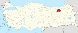 Location of Bayburt Province in Turkey | |
| Country | Turkey |
| Region | Northeast Anatolia |
| Subregion | Erzurum |
| Government | |
| • Electoral district | Bayburt |
| Area | |
| • Total | 3,652 km2 (1,410 sq mi) |
| Population (2018)[1] | |
| • Total | 82,274 |
| • Density | 23/km2 (58/sq mi) |
| Area code(s) | 0458 |
| Vehicle registration | 69 |
Geography
Bayburt is traversed by the northeasterly line of equal latitude and longitude.
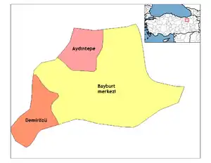
Districts
Bayburt province is divided into 3 districts (capital district in bold):
Historical places
The most important places in Bayburt Province are:[2]
- Bayburt Tower
- Saruhan Tower
- Aydıntepe underground city
- Mausoleum of Dede Korkut
- Mausoleum of Şehit Osman
- Traditional Bayburt houses
- Ulu Mosque
- Pulur (Gökçedere) Ferahşat Bey Mosque
- Sünür (Çayıryolu) Kutlu Bey Mosque
- Yukarı Hınzeverek (Çatalçeşme) Mosque
- Bedesten (covered bazaar)
- Varzahan Armenian Church
Cities and towns
Climate
The climate is described as Humid Continental by the Köppen Climate System, abbreviated as Dfb.[3]
See also
References
- "Population of provinces by years - 2000-2018". Turkish Statistical Institute. Retrieved 9 March 2019.
- Bayburt Tarihi yerler Archived May 10, 2012, at the Wayback Machine (in Turkish)
- Climate Summary for Bayburt
External links
| Wikimedia Commons has media related to Bayburt Province. |
- (in Turkish) Bayburt governor's official website
- (in English) Bayburt weather forecast information
| ||
Metropolitan municipalities are bolded. | ||
| Authority control |
|---|
This article is issued from Wikipedia. The text is licensed under Creative Commons - Attribution - Sharealike. Additional terms may apply for the media files.