Tokat Province
Tokat Province (Turkish: Tokat ili) is a province in northern Turkey. Its adjacent provinces are Amasya to the northwest, Yozgat to the southwest, Sivas to the southeast, and Ordu to the northeast. Its capital is Tokat, which lies inland of the middle Black Sea region, 422 kilometers from Ankara.
Tokat Province
Tokat ili | |
|---|---|
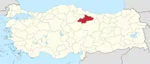 Location of Tokat Province in Turkey | |
| Country | Turkey |
| Region | West Black Sea |
| Subregion | Samsun |
| Government | |
| • Electoral district | Tokat |
| Area | |
| • Total | 9,959 km2 (3,845 sq mi) |
| Population (2018)[1] | |
| • Total | 612,646 |
| • Density | 62/km2 (160/sq mi) |
| Area code(s) | 0356 |
| Vehicle registration | 60 |
Etymology
Evliya Çelebi explained the name of the city as Tok-at in return for the satiety of horses because of its rich barley in Turkish etymology. The Ottoman historian İsmail Hakkı explained Uzunçarşılı as Toh-kat, which means "walled city", and Özhan Öztürk, in his work called Pontus, used the word "Dahyu", which means "country, chastity" in Avesta and was first used for Cappadocia in the 6th century BC during the Achaemenid Empire. He claimed that the word "Dokeia", which was corrupted in the Greek dialect, turned into Tokat in time.
History
Tokat believed to have been founded by the Togayites in the early ages. Tokat, after remaining under the rule of the Hittites, Assyrians, Hurrians and Cimmerians, passed under the rule of Persians, Macedonians of Alexander the Great period, Capodocia Kingdom and Pontus Kingdom, which gave the name "Comana Pontica". In 65 BC, it came under the rule of the Romans and the Byzantine Empire. Tokat Castle, which has a critical importance in Byzantine-Sassanid and Byzantine-Arab wars, is located on Hisartepe, 750 meters high, in the southwest of the city, which was taken under the rule of the Danismendids (1071) after the Malazgirt Victory and later by the Anatolian Seljuks (1150). The oldest traces of Tokat Castle belong to the 5th or 6th century and it is known that the castle existed in these years.
Geography
The city, which originates from the northern slopes of the central part of Deveci Mountains and joins Yeşilırmak on the left, is located on the slopes of a river valley, and is located at the junction of important roads connecting the Central Black Sea coast and Central and Eastern Anatolia in a very rugged region. Total area of the province: 10.071 km². In terms of the footprint area it covers 1.3% of Turkey's land. It is 623 meters above sea level. Geographical Coordinates: Being between 39 ° 51 '- 40 ° 55' north latitudes and 35 ° 27'- 37 ° 39 'East longitudes, Tokat became a province in 1923.
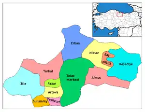
Districts
Tokat province is divided into 12 districts (capital district in bold):
Landmarks
Two notable monuments in this province are the Hatuniye Medrese of the 15th century, built by Sultan Bayezid II, and a Seljuk bridge spanning the Yeşilırmak River, belonging to the 12th century. The Latifoğlu Mansion is a third, which is an example of the traditional architecture of a Turkish house of the 19th century, restored recently to its original state. Tokat Castle and Zile, Niksar and Turhal castles located in Tokat district are frequented by local and foreign tourists. In the city center of Tokat, the historical Tokat Clock Tower and the historical Gök Madrasa is placed. Additionally, The Yağıbasan Madrasah, known as the first madrasah built in Anatolia, the historical Pazar Caravanserai and the Ballıca Cave are located.
Economy
The people of Tokat earn their living from agriculture, animal husbandry and trade. The city is an ideal city for a peaceful life with its regular city structure, numerous natural beauties and economic shopping conditions. Trade and industry of Tokat, whose economy is based on agriculture and animal husbandry, is concentrated in the city center. Tokat Organized Industrial Zone is the area where the city's only industrial activity continues. Again, with its geographical location, it is a city that is suitable for agriculture. In agricultural production, tomatoes, peppers, cherries, cherries, potatoes, grapes and sugar beet are the products that have the largest share in the regional production.
Climate
| Months | January | February | March | April | May | June | July | August | September | October | November | December | |
|---|---|---|---|---|---|---|---|---|---|---|---|---|---|
| Average Maximum °C (1970 - 2011) | 20.2 | 22.8 | 31.1 | 33.5 | 36.1 | 38.5 | 45.0 | 40.8 | 37.9 | 35.3 | 27.6 | 23.0 | |
| Average Lowest °C (1970 - 2011) | -23.4 | -22.1 | -21.1 | -4.5 | 0.0 | 3.2 | 6.1 | 7.8 | 2.4 | -3.2 | -8.3 | -21.0 | |
| Resource: Turkish State Meteorological Service[2] | |||||||||||||
Gallery
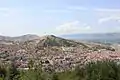 Tokat
Tokat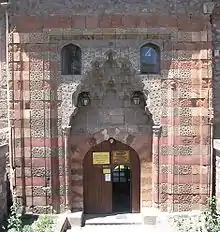 Gök Medrese in Tokat
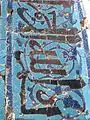 Polychrome tiles from Gök Medrese
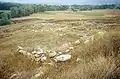 Maşat Höyük, a Hittite archaeological site
 Atatürk's House Museum
 Tokat Mevlevihanesi
References
- "Population of provinces by years - 2000-2018". Turkish Statistical Institute. Retrieved 9 March 2019.
- Meteoroloji Genel Müdürlüğü-Tokat Resmi İstatistikler, Turkish State Meteorological Service
External links
| Wikimedia Commons has media related to Tokat Province. |
- (in Turkish) Tokat governor's official website
- (in Turkish) Tokat municipality's official website
- (in English) Tokat weather forecast information
- Pictures of the capital of Tokat province, with links to others nearby
| ||
Metropolitan municipalities are bolded. | ||