Brenham, Texas
Brenham (/ˈbrɛnəm/ BREH-nəm) is a city in east-central Texas in Washington County, United States, with a population of 15,716 according to the 2010 U.S. census. It is the county seat of Washington County.[5] Brenham is south of College Station, and about halfway between Houston and Austin approximately 70 miles (110 km) northwest of Houston, and about 90 miles (140 km) east of Austin.
Brenham, Texas | |
|---|---|
 Location of Brenham, Texas | |
| Coordinates: 30°9′43″N 96°23′49″W | |
| Country | United States |
| State | Texas |
| County | Washington |
| Government | |
| • Mayor | Milton Y. Tate, Jr. |
| Area | |
| • Total | 13.03 sq mi (33.74 km2) |
| • Land | 12.98 sq mi (33.61 km2) |
| • Water | 0.05 sq mi (0.13 km2) |
| Elevation | 341 ft (104 m) |
| Population (2010) | |
| • Total | 15,716 |
| • Estimate (2019)[2] | 17,863 |
| • Density | 1,376.51/sq mi (531.48/km2) |
| Time zone | UTC-6 (Central (CST)) |
| • Summer (DST) | UTC-5 (CDT) |
| ZIP codes | 77833-77834 |
| Area code(s) | 979 |
| FIPS code | 48-10156[3] |
| GNIS feature ID | 1331223[4] |
| Website | www |

Brenham is renowned as the heart of the bluebonnet region in Central Texas. The local chamber of commerce promotes the Bluebonnet Trails and offers free maps to guide visitors along the most scenic wildflower routes, which also pass historic sites and attractions.
Washington County is known as the "Birthplace of Texas," as it contains the site of the signing of the Texas Declaration of Independence on March 2, 1836 in the town of Washington-on-the-Brazos. This is now a state historic site.
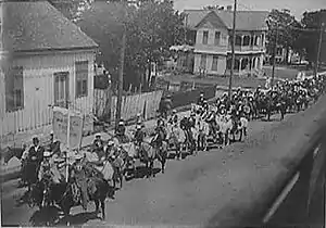
Brenham is also known for its annual German heritage festival that takes place each May called Maifest, similar to Volksfest.[6] Numerous German immigrants settled here in the mid-nineteenth century, following the Revolutions in German states in 1848. Brenham is also the Home of "The World's Largest BBQ Pit" on 290 West.
Geography
Brenham is located at 30°9′43″N 96°23′49″W (30.161901, -96.397004).[7]
According to the United States Census Bureau, the city has a total area of 8.8 square miles (22.7 km2), all of it land.
Demographics
| Historical population | |||
|---|---|---|---|
| Census | Pop. | %± | |
| 1860 | 920 | — | |
| 1870 | 2,221 | 141.4% | |
| 1880 | 4,101 | 84.6% | |
| 1890 | 5,209 | 27.0% | |
| 1900 | 5,968 | 14.6% | |
| 1910 | 4,718 | −20.9% | |
| 1920 | 5,066 | 7.4% | |
| 1930 | 5,974 | 17.9% | |
| 1940 | 6,435 | 7.7% | |
| 1950 | 6,941 | 7.9% | |
| 1960 | 7,740 | 11.5% | |
| 1970 | 8,922 | 15.3% | |
| 1980 | 10,966 | 22.9% | |
| 1990 | 11,952 | 9.0% | |
| 2000 | 13,507 | 13.0% | |
| 2010 | 15,716 | 16.4% | |
| 2019 (est.) | 17,863 | [2] | 13.7% |
| U.S. Decennial Census[8] | |||
College students make up about half of the population of Brenham. As of 2014, the 17,707 students enrolled at Blinn College amounted to an estimated 51.4% of the city's population.[9]
As of the census[3] of 2000, there were 13,507 people, 4,907 households, and 3,115 families residing in the city. The population density was 1,541.5 people per square mile (595.3/km2). There were 5,317 housing units at an average density of 606.8 per square mile (234.3/km2). The racial makeup of the city was 69.99% White, 21.91% African American, 0.25% Native American, 1.86% Asian, 0.01% Pacific Islander, 4.75% from other races, and 1.22% from two or more races. Hispanic or Latino of any race were 10.25% of the population. There were 4,907 households, out of which 30.0% had children under the age of 18 living with them, 45.7% were married couples living together, 14.2% had a female householder with no husband present, and 36.5% were non-families. 30.7% of all households were made up of individuals, and 15.4% had someone living alone who was 65 years of age or older. The average household size was 2.40 and the average family size was 3.01.
In the city, the population was spread out, with 22.5% under the age of 18, 15.9% from 18 to 24, 24.7% from 25 to 44, 18.8% from 45 to 64, and 18.2% who were 65 years of age or older. The median age was 35 years. For every 100 females, there were 89.1 males. For every 100 females age 18 and over, there were 86.6 males.
The median income for a household in the city was $32,198, and the median income for a family was $41,486. Males had a median income of $31,133 versus $22,152 for females. The per capita income for the city was $15,351. About 12.8% of families and 17.7% of the population were below the poverty line, including 21.9% of those under age 18 and 20.7% of those age 65 or over.
Transportation
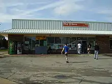
Until 2009 Greyhound Lines offered bus services from the Stop N'Save at 601 East Main Street, but as of 2015 Brenham is not served by intercity bus.
Industry
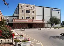
Brenham is the home of and headquarters for Blue Bell Creameries. Blue Bell is the 4th best-selling ice cream brand in the United States, and is sold in 16 states.
Brenham is also home to a large Valmont Industries industrial plant, where metal poles are manufactured.
The city is the site of the Brenham State Supported Living Center, the largest facility in Texas for providing housing and care to intellectually disabled persons.
Education
The City of Brenham's primary education is provided by Brenham Independent School District (BISD) and various private schools. The public schools in BISD include Brenham Elementary, Krause Elementary, Alton Elementary, Brenham Middle School, Brenham Junior High, and Brenham High School. The mascot for Brenham high school is the lion cub.
Brenham is also the home of Blinn College, the oldest county-owned junior college in Texas. Blinn has campuses also in Bryan, Schulenburg, and Sealy.
Notable people
- Courtland Sutton (born 1995), professional football player (Broncos 2018 - current)
- Sadie Sink (born 2002), actress
- Malcom Brown (born 1994), professional football player
- Timothy Brian Cole (1960–1999), The first person in Texas to receive a posthumous pardon and the first posthumous DNA Exonerated person in the United States
- Cecil Cooper (born 1949), professional baseball player
- Hosea Garrett (1800–1888), clergyman, cofounder of Baylor University
- Jack Heidemann (born 1949), professional baseball player
- Don Imus (1940–2019), radio and TV personality, recording artist and author
- Blind Willie Johnson (1897–1945), singer, songwriter, guitarist
- Lois Kolkhorst (born 1964), state politician, state representative from Brenham from 2001 to 2015, and state senator since 2015
- Roosevelt Leaks (born 1953), professional football player
- Chuck Machemehl (born 1946), professional baseball player
- Frank Malina (1912–1981), aeronautical engineer and director of NASA's Jet Propulsion Laboratory, entrepreneur, rocket researcher, artist
- Paul Pressler (born 1930), retired judge from Houston; owns Hidden Hills Ranch near Brenham
- Luke Sanders (born 1985), UFC fighter
- Austin Schlottmann (born 1995), professional football player (Broncos 2018 - current)
- Leighton Schubert (born 1982), member of the Texas House of Representatives for District 13 since 2015; born in Brenham, lawyer in Caldwell, Texas
- Ricky Seilheimer (born 1960), professional baseball player
- Darden Smith (born 1962), songwriter, musician
- Gary Weiss (born 1955), former shortstop for the Los Angeles Dodgers.
- Wilson Whitley (1955–1992), professional football player
- Will Ezell (1892-1963), barrelhouse pianist
- Roger Metzger , Professional baseball player Houston Astros
Government and infrastructure
The city elects its mayor and city council.
Mayors of the City of Brenham, Texas:
|
|
The Texas Department of Aging and Disability Services operates the Brenham State Supported Living Center (formerly Brenham State School).[10]
The United States Postal Service operates the Brenham Post Office.[11]
Climate
The climate in this area is characterized by relatively high temperatures and evenly distributed precipitation throughout the year. The Köppen Climate System describes the weather as humid subtropical, and uses the abbreviation Cfa.[12]
See also
References
- "2019 U.S. Gazetteer Files". United States Census Bureau. Retrieved August 7, 2020.
- "Population and Housing Unit Estimates". United States Census Bureau. May 24, 2020. Retrieved May 27, 2020.
- "U.S. Census website". United States Census Bureau. Retrieved 2008-01-31.
- "US Board on Geographic Names". United States Geological Survey. 2007-10-25. Retrieved 2008-01-31.
- "Find a County". National Association of Counties. Archived from the original on 2011-06-15. Retrieved 2011-06-07.
- Texas State Historical Commission. "The Brenham Maifest, Texas State Historical Marker".
- "US Gazetteer files: 2010, 2000, and 1990". United States Census Bureau. 2011-02-12. Retrieved 2011-04-23.
- "Census of Population and Housing". Census.gov. Retrieved June 4, 2015.
- Florida, Richard (2016-09-08). "The Reality of America's College Towns". Bloomberg CityLab. Retrieved 2020-12-09.
- "Brenham State Supported Living Center" Archived August 20, 2010, at the Wayback Machine, Texas Department of Aging and Disability Services. Retrieved on August 8, 2010.
- "Post Office Location - BRENHAM Archived July 15, 2010, at the Wayback Machine." United States Postal Service. Retrieved on August 8, 2010.
- Climate Summary for Brenham, Texas
External links
| Wikimedia Commons has media related to Brenham, Texas. |
| Wikisource has the text of the 1911 Encyclopædia Britannica article Brenham. |
- City of Brenham Web Site
- Brenham, Texas from the Handbook of Texas Online
- Economic Development Foundation of Brenham
Municipalities and communities of Washington County, Texas, United States | ||
|---|---|---|
| cities | 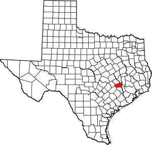 Washington County map | |
| Unincorporated communities | ||
| Ghost towns |
| |
| Footnotes | ‡This populated place also has portions in an adjacent county or counties | |
| ||

| Authority control |
|---|