British Columbia Highway 13
Highway 13 is an 11.5 km (7.1 mi) long two-lane route through the eastern part of Langley, British Columbia. Highway 13 essentially serves the function of quick access from Washington state to the central Fraser Valley, and vice versa. Highway 13 first opened in 1958 between the Canada–United States border and the present day Fraser Highway (former Highway 1A), and was extended north to the present day Trans-Canada Highway (Highway 1) in 1968.
| ||||
|---|---|---|---|---|
| 264th Street Aldergrove-Bellingham Highway | ||||
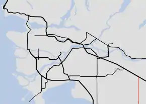 Highway 13 highlighted in red. | ||||
| Route information | ||||
| Length | 11.50 km[1] (7.15 mi) | |||
| Existed | 1958–present | |||
| Major junctions | ||||
| South end | ||||
| North end | ||||
| Highway system | ||||
British Columbia provincial highways
| ||||

Route details
Highway 13 begins in the south at its connection to Washington State Route 539 at the international border, and follows 264th Street north for 6.5 km (4.0 mi) to its junction with Fraser Highway at Aldergrove. Highway 13 continues north for 5 km (3.1 mi) to end at an interchange with Highway 1.
Major intersections
From south to north. The entire route is in the Langley Township, Metro Vancouver.
| Location | km[1] | mi | Destinations | Notes | |
|---|---|---|---|---|---|
| | 0.00 | 0.00 | Continues into Washington | ||
| Canada – United States border at Lynden–Aldergrove Border Crossing | |||||
| Aldergrove | 6.54 | 4.06 | Fraser Highway – Langley City Centre, Abbotsford | Former Hwy 1A | |
| | 11.50 | 7.15 | 264th Street | Interchange (Hwy 1 Exit 73) | |
| 1.000 mi = 1.609 km; 1.000 km = 0.621 mi | |||||
References
- Landmark Kilometre Inventory (PDF). British Columbia Ministry of Transportation and Infrastructure (Report). Cypher Consulting. July 2016. p. 217. Archived from the original (PDF) on 2017-03-11. Retrieved 2017-03-21.