British Columbia Highway 5
Highway 5 is a 543 km (337 mi) north-south route in southern British Columbia, Canada. Highway 5 connects the southern Trans-Canada route (Highway 1) with the northern Trans-Canada/Yellowhead route (Highway 16), providing the shortest land connection between Vancouver and both Edmonton and Calgary. Despite the entire route being signed as part of the Yellowhead Highway, the portion of Highway 5 south of Kamloops is also known as the Coquihalla Highway while the northern portion is known as the Southern Yellowhead Highway. The Coquihalla section was a toll road until 2008.
| ||||
|---|---|---|---|---|
| Southern Yellowhead Highway Coquihalla Highway | ||||

Highway 5 highlighted in red. | ||||
| Route information | ||||
| Length | 543.3 km[1] (337.6 mi) Coquihalla Highway: 185.6 km (115.3 mi) | |||
| Existed | 1941–present | |||
| Major junctions | ||||
| South end | ||||
| North end | ||||
| Location | ||||
| Districts | Hope, Barriere, Clearwater | |||
| Major cities | Merritt, Kamloops | |||
| Villages | Valemount | |||
| Highway system | ||||
British Columbia provincial highways
| ||||
.svg.png.webp)
Although the Yellowhead Highway system is considered part of the Trans-Canada Highway network, the Highway 5 segment is not marked as such. However, Highway 5 is designated as a core route of Canada's National Highway System.
Route description
Overview
Highway 5 begins south at the junction with Crowsnest Highway (Highway 3) at uninhabited Othello, 7 km (4 mi) east of Hope (named after a nearby siding on the Kettle Valley Railway, which used many Shakespearean names). Exit numbers on the Coquihalla are a continuation of those on Highway 1 west of Hope. 35 km (22 mi) north of Othello, after passing through five interchanges, Highway 5 reaches the landmark Great Bear snow shed. The location of the former toll booth is 13 km (8 mi) north of the snow shed, passing through another interchange and the 1,244 m (4,081 ft) Coquihalla Pass. Highway 5 was the only highway in British Columbia to have tolls; a typical passenger vehicle toll was C$10.[2] Now free to drive, at the Coquihalla Lakes junction, the highway crosses from the Fraser Valley Regional District into the Thompson-Nicola Regional District. 61 km (38 mi) and five interchanges north of the former toll plaza, the Coquihalla enters the city of Merritt. There it joins Highway 5A and Highway 97C.
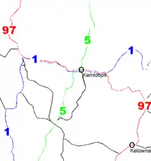
Highway 5 travels 4 km (2.5 mi) through the eastern area of Merritt before reaching its northern junction with Highway 5A. From there, the Coquihalla has three more interchanges and one mountain pass – the Surrey Lake Summit – in the 72 km (45 mi) between Merritt and its end at a junction with Highways 1 and 97. Highway 5 continues east for 12 km (7.5 mi) concurrently with Highways 1 and 97, through Kamloops. This stretch of road, which carries 97 South and 5 North on the same lanes (and vice versa), is the only wrong-way concurrency in British Columbia.
After separating from Highways 1 and 97, Highway 5 proceeds north for approximately 19 km (12 mi), temporarily leaving Kamloops city limits as a four-lane highway, before re-entering the city at the Rayleigh community, then continuing north. It becomes a two-lane highway at Heffley Creek and the exit to Sun Peaks resorts, both of which indicate the final northern boundary of Kamloops.
Highway 5 follows the North Thompson River north from Heffley Creek for approximately 54 km (34 mi), along a parallel course with a branch of the Canadian National Railway, passing through Barriere, to a junction with Highway 24 at Little Fort. 30 km (19 mi) north of Little Fort, while continuing to follow the North Thompson and the CN Railway, Highway 5 then reaches the community of Clearwater. It proceeds northeast for another 107 km (66 mi), passing Vavenby and Avola en route to the community of Blue River; then 109 km (68 mi) further north through the Columbia Mountains, it crosses into the Regional District of Fraser-Fort George, passing by the community of Valemount to its northern terminus at Tête Jaune Cache, where it meets Highway 16.
Coquihalla Highway
South of Kamloops, Highway 5 is known as the Coquihalla Highway (colloquially "the Coq"; pronounced "coke"), 186 km (116 mi) of freeway, varying between four and six lanes with a variable speed limit of 120 km/h (75 mph). The Coquihalla approximately traces through the Cascade Mountains the route of the former Kettle Valley Railway, which existed between 1912 and 1958. It is so-named because near Hope, it generally follows the Coquihalla River, for about 60 km (37 mi), and uses the Coquihalla Pass.
Signs along the Coquihalla Highway frequently warn drivers to be aware of sudden changes in weather. The highway is particularly dangerous during winter seasons, with extreme snowfall that can exceed more than 10 centimetres (4 in) per hour.[3] While road maintenance strives to keep the roads as clear as possible, it is not unheard of for the highway to shut down, sometimes with travellers forced to stay overnight in their cars.
According to ICBC there were 32 fatal crashes between 2004 and 2013, and an estimated 400-500 accidents occur during the winter seasons.[4] Global News listed the stretch between Merritt and Hope as one of the deadliest highways in BC.[5] DriveBC keeps up to date with reports on Coquihalla Highway conditions, including live webcams in several locations.[6]
History

.svg.png.webp)
The current Highway 5 is not the first highway in B.C. to have this designation. From 1941 to 1953, the section of present-day Highway 97, Highway 97A, and Highway 97B, between Kaleden, just south of Penticton, and Salmon Arm, was formerly Highway 5. In 1953, the '5' designation was moved to designate Princeton-Merritt-Kamloops Highway (present-day Highway 5A) to north of Kamloops; by 1960 Highway 5 was extended north to Tête Jaune Cache and subsequently paved.[7] In 1970, Highway 5 between Kamloops and Tête Jaune Cache was designated as the South Yellowhead Highway and signed with the Yellowhead Highway shield, while the section south of Kamloops was still signed with the standard British Columbia highway shield.[8]
In the 1960s, the Merritt Board of Trade began lobbying the B.C. government for a new highway route to Hope, including a vehicle caravan that was staged eight times starting in 1963, over the abandoned Kettle Valley Railway grade, in order draw attention to the potential of this route.[9] Surveying commenced in 1973 and in 1979 the first construction contract was issued for 4.5 km (2.8 mi) section of highway between Nicolum Creek and Peers Creek near Hope; however, work progressed slowly until 1984 when Premier Bill Bennett announced that the project would be fast-tracked so it could be completed to coincide with Expo 86.[9][10] To ensure the project was completed on time, more than 10,000 people were needed to fill all of the jobs and more than 1,000 pieces of heavy equipment worked non-stop every day during the summer of 1985 to get it done.[10] The project was divided into three phases, with Phase 1 being the 115 km (71 mi) section between Hope and Merritt, Phase 2 being the 80 km (50 mi) section between Merritt and Kamloops, and Phase 3 being a 108 km (67 mi) branch between Merritt and Peachland, south of Kelowna.[9] In order to offset the cost of fast-tracking construction, Phase 1 was made a toll highway, with a toll plaza constructed at the summit of Coquihalla Pass; was designed to accommodate 13 toll booths for 14 lanes of traffic.[9]
On May 16, 1986, Phase 1 was officially opened and Highway 5 was re-routed between Hope and Merritt. The opening celebrations featured a ceremony in Hope followed by a convoy led the Premier in an open air convertible that smashed through paper banners strung across the new highway lanes, stopped at the Coquihalla summit to dedicate a time capsule, and continued to Merritt for further celebrations.[9] The total cost for the highway between Hope and Merritt was approximately $848 million.[11] Phase 2 between Merritt and Kamloops opened in September 1987, re-routing Highway 5, while Phase 3 was opened in October 1990 and designated as Highway 97C.[9] The three phases have been credited with transforming Merritt into an important transportation hub between the coast and interior, as well as significant growth in both Kamloops and the Okanagan due to improved accessibility.[10]
In 2003, Premier Gordon Campbell announced the Liberal government would turn over toll revenue to a private operator, along with responsibility for operation, and maintenance of "the Coq".[12] In response to strong opposition from the public, and numerous businesses, in the Interior of British Columbia, the provincial government shelved the move three months later.[13]
On September 26, 2008, the provincial government permanently lifted the Coquihalla tolls, effective 1:00 pm that day.[11][14] Subsequently, the toll station and signs were dismantled.[15]
In 2011, the British Columbia government replaced the standard British Columbia Highway 5 shields with Yellowhead Highway 5 shields south of Kamloops, which at the time drew some concern that the Coquihalla Highway would be officially renamed.[16][17]
Effective July 2, 2014, the Ministry of Transport and Infrastructure increased the speed limit of Coquihalla Highway from 110 km/h (68 mph) to 120 km/h (75 mph) after conducting an engineering assessment and province-wide speed review.[18] In June 2016, the province implemented a variable speed limit corridor around the Coquhalla Summit Park to increase safety during adverse conditions.
Exit list
From south to north, the following intersections are observed along Highway 5:[19][20]
| Regional District | Location | km[1] | mi | Exit[21] | Name[21] | Destinations | Notes |
|---|---|---|---|---|---|---|---|
| Freeway and exit numbers continues along | |||||||
| Fraser Valley | Hope | 0.00 | 0.00 | 170 | Hope | West end of Hwy 3 concurrency; no westbound exit | |
| 0.99 | 0.62 | 171 | Westbound exit only | ||||
| 3.08 | 1.91 | 173 | Thacker Creek | Old Hope-Princeton Way (Hwy 915:1300 west) | Hwy 915:1300 is unsigned; no westbound entrance | ||
| | 6.67 | 4.14 | 177 | Othello | East end of Hwy 3 concurrency | ||
| South end of Coquihalla Highway | |||||||
| 13.00 | 8.08 | 183 | Peers Creek | Othello Road – Coquihalla Canyon Provincial Park | |||
| 22.02 | 13.68 | 192 | Jessica | Sowaqua Creek Road | |||
| 25.77 | 16.01 | 195 | Carolin | Carolin Mines Road | |||
| 29.68 | 18.44 | 200 | Shylock | Shylock Road (U-turn route only) | Southbound exit and northbound entrance. | ||
| 31.19 | 19.38 | 202 | Portia | Portia, Old Coquihalla Road | No southbound exit. | ||
| 42.21 | 26.23 | Great Bear Snowshed | |||||
| 45.53 | 28.29 | 217 | Zopkios | Zopkios rest area | |||
| 48.93 | 30.40 | Coquihalla Pass – 1,244 m (4,081 ft) | |||||
| 51.35 | 31.91 | 221 | Falls Lake | Falls Lake Road | |||
| ↑ / ↓ | | 52.22 | 32.45 | Dry Gulch Bridge | |||
| Thompson-Nicola | | 58.11 | 36.11 | 228 | Coquihalla Lakes | Coquihalla Lakes Road – Britton Creek Rest Area | |
| 61.09 | 37.96 | 231 | Mine Creek | Mine Creek Road (U-turn route only) | Southbound exit and northbound entrance. | ||
| 61.2 | 38.0 | 238 | Juliet | Juliet Creek Road – Coldwater River Provincial Park | |||
| 79.69 | 49.52 | 250 | Larson Hill | Larson Hill | |||
| 86.46 | 53.72 | 256 | Kingsvale | Coldwater Road | |||
| 106.32 | 66.06 | 276 | Comstock | Comstock Road | |||
| Merritt | 115.99 | 72.07 | 286 | Coldwater | |||
| 119.96 | 74.54 | 290 | Nicola | ||||
| | 145.31 | 90.29 | 315 | Helmer | Helmer Road | ||
| 152.60 | 94.82 | Surrey Lake Summit – 1,444 m (4,738 ft) | |||||
| 167.11 | 103.84 | 336 | Walloper | ||||
| 185.48 | 115.25 | 355 | Inks Lake | Inks Lake Road | |||
| Kamloops | 192.22 | 119.44 | 362 | Afton | West end of Hwy 1 / Hwy 97 concurrency | ||
| North end of Coquihalla Highway | |||||||
| 196.45 | 122.07 | 366 | Copperhead | Copperhead Drive, Lac le Jeune Road | |||
| 198.13 | 123.11 | 367 | Pacific Way | Pacific Way | |||
| 198.92 | 123.60 | 368 | Aberdeen | ||||
| 200.22 | 124.41 | 369 | Sagebrush | Columbia Street – City Centre | Eastbound exit and westbound entrance | ||
| 200.80 | 124.77 | 370 | Springhill | Summit Drive – City Centre | Westbound exit and eastbound entrance | ||
| 204.29 | 126.94 | 374 | Yellowhead | East end of Hwy 1 / Hwy 97 concurrency | |||
| South end of Southern Yellowhead Highway • Hwy 5 exits freeway using Exit 374. | |||||||
| ↑ / ↓ | 204.74 | 127.22 | Yellowhead Bridge over South Thompson River | ||||
| Kamloops No. 1 | 206.09 | 128.06 | Shuswap Road | Signalized, at-grade intersection | |||
| 208.16 | 129.34 | Mount Paul Way | Signalized, at-grade intersection | ||||
| 210.04 | 130.51 | Signalized, at-grade intersection; Hwy 915:1771 and Hwy 915:1773 is unsigned | |||||
| Kamloops | 220.16 | 136.80 | Puett Ranch Road | ||||
| 228.74 | 142.13 | Tod Mountain Road (Hwy 921:1776 east) – Sun Peaks | Hwy 915:1776 is unsigned | ||||
| Barriere | 267.64 | 166.30 | Barriere Town Road, Lilley Road | ||||
| 270.06 | 167.81 | Barriere North Thompson Bridge across North Thompson River | |||||
| Little Fort | 297.88 | 185.09 | |||||
| | 319.86 | 198.75 | Old North Thompson Highway (Hwy 921:1765 north) | Hwy 921:1765 is unsigned | |||
| Clearwater | 327.04 | 203.21 | Old North Thompson Highway, Clearwater Village Road | Connects to unsigned Hwy 921:1765 south | |||
| 328.08 | 203.86 | Clearwater Valley Road, Park Drive – Wells Gray Provincial Park | Roundabout | ||||
| Avola | 395.43 | 245.71 | Avola North Thompson Bridge across North Thompson River | ||||
| | 423.68 | 263.26 | Six Mile Bridge across North Thompson River | ||||
| Blue River | 434.43 | 269.94 | Angus Horne Street, Shell Road | ||||
| | 474.40 | 294.78 | Lempriere Bridge across North Thompson River | ||||
| 477.34 | 296.61 | Moombeam Bridge across North Thompson River | |||||
| 478.91 | 297.58 | Gosnell Bridge across North Thompson River | |||||
| Fraser-Fort George | Valemount | 523.94 | 325.56 | 5th Avenue, Pine Road | Signalized, at-grade intersection | ||
| Tête Jaune Cache | 543.13 | 337.49 | Tête Jaune Bridge across Fraser River | ||||
| 543.33 | 337.61 | Tête Jaune | Interchange | ||||
1.000 mi = 1.609 km; 1.000 km = 0.621 mi
| |||||||
Name
An archived article from the BC government website provides insight on the name Coquihalla: "Kw'ikw'iya:la (Coquihalla) in the Halq'emeylem language of the Stó:lō, is a place name meaning 'stingy container.' It refers specifically to a fishing rock near the mouth of what is now known as the Coquihalla River. This rock is a good platform for spearing salmon. According to Stó:lō oral history, the skw'exweq (water babies, underwater people) who inhabit a pool close by the rock, would swim out and pull the salmon off the spears, allowing only certain fisherman to catch the salmon."[22] The route is also often referred to simply as "The Coq" (pronounced "coke").
Popular culture
- Highway 5 is the main highway serviced in Discovery Channel show, Highway Thru Hell.
- The song "Hurtin' Albertan" by country singer Corb Lund makes reference to the Coquihalla in the lyric "...there's good weather up on the Coke."
- The Canadian pop-punk band Chixdiggit featured a song about the road, "I Drove The Coquihalla," on its self-titled debut Chixdiggit! (Sub Pop, 1996).
Gallery
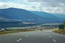
 Highway 5 passing through Thompson Plateau
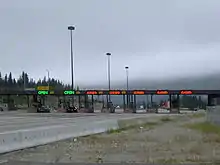 The toll booth once marked the halfway point of the formerly tolled Hope-to-Merritt portion of the highway.
- Passing Nicola Valley southbound.
 Downtown Valemount as seen from the west side of Highway 5.
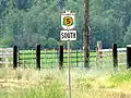 Southern Yellowhead Highway 5, southbound.
References
- Landmark Kilometre Inventory (PDF). British Columbia Ministry of Transportation and Infrastructure (Report). Cypher Consulting. July 2016. pp. 171–176, 202. Archived from the original (PDF) on 2017-03-11. Retrieved 2017-04-21.
- "Coquihalla Highway tolls dropped, says B.C. premier". CBC News. Canadian Broadcasting Corporation. September 26, 2008.
- "What You Need to Know About Winter Weather on the "Coq"". TranBC. Ministry of Transportation and Infrastructure.
- "Coquihalla Highway". dangerousroads.
- McElroy, Justin (February 9, 2015). "British Columbia's 12 deadliest highways". Global News. Corus Entertainment Inc.
- "B.C. Highway Cams". Drive BC. Government of British Columbia.
- Department of Highways (1960). Province of Alberta Official Road Map (PDF) (Map). Government of Alberta. §§ A-4, A-5, B-5, B-6.
- Department of Travel Industry. Beautiful British Columbia Road Map & Provincial Campground Guide (Map) (1972-1973 ed.). Government of the Province of British Columbia. §§ O-7, P-6, P-7, Q-5.
- Wilson, Inge (May 8, 2011). "New route changed the face of the province forever". Hope Standard. Archived from the original on May 25, 2019. Retrieved May 25, 2019.
- "Construction of the Coquihalla: Still Amazing After 30 Years". TranBC: Ministry of Transportation and Infrastructure. Government of British Columbia. Archived from the original on July 7, 2018. Retrieved May 25, 2019.
- Tolls taken off Coquihalla
- Richards, Gwendolyn (May 6, 2003). "B.C. government privatizing toll highway". The Globe and Mail. Retrieved November 20, 2018.
- Hume, Mark (July 23, 2003). "B.C. won't privatize Coquihalla Highway". The Globe and Mail. Retrieved November 20, 2018.
- "Premier Announces End of Tolls". Archived from the original on 2008-09-30. Retrieved 2008-09-26.
- Coquihalla Tollbooths Demolished
- Reimer, Elmer (May 31, 2012). "Alberta highway shouldn't claim Coquihalla". Merritt Herald. Retrieved May 25, 2019.
- Jason, Hewlett (November 14, 2012). "Called the Coquihalla no more?". Kamloops Daily News. Retrieved May 25, 2019.
- "Actions to improve safety on B.C.'s rural highways". Archived from the original on 2014-07-07. Retrieved 2014-07-04.
- Tourism British Columbia. Super, Natural British Columbia Road Map & Parks Guide (Map) (2010-2011 ed.). Davenport Maps Ltd. §§ H-10, J-9, J-10, K-9, L-9.
- British Columbia Road Atlas (2007 ed.). Oshawa, ON: MapArt Publishing Corp. pp. 37, 46, 47, 57, 58, and 69. ISBN 1-55368-018-9.
- "Highway Exits & Landmarks - Coquihalla Highway 5 Starts (Yellowhead Route)". British Columbia Ministry of Transportation and Infrastructure. Archived from the original on 15 July 2016. Retrieved 13 July 2016.
- B.C. Ministry of Transportation Archived August 25, 2007, at the Wayback Machine - Coquihalla Rates and Information
External links
 Media related to British Columbia Highway 5 at Wikimedia Commons
- 7 Things You Need to Know BEFORE Driving the Coquihalla and High Mountain Passes