Washington State Route 539
State Route 539 (SR 539, named the Guide Meridian) is a north–south state highway in the U.S. state of Washington. The highway travels through northwestern Whatcom County and connects Interstate 5 (I-5) in Bellingham with Lynden and the Canadian border near Langley, British Columbia. Its name, the Guide Meridian, is derived from the Guide meridian that it follows while traveling due north–south.
| ||||
|---|---|---|---|---|
| Guide Meridian | ||||
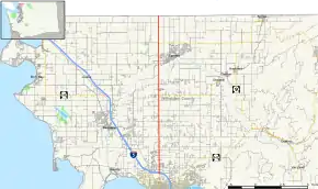 A map of western Whatcom County with SR 539 is highlighted in red. | ||||
| Route information | ||||
| Auxiliary route of I-5 | ||||
| Defined by RCW 47.17.785 | ||||
| Maintained by WSDOT | ||||
| Length | 15.18 mi[1] (24.43 km) | |||
| Existed | 1969–present | |||
| Major junctions | ||||
| South end | ||||
| North end | ||||
| Location | ||||
| Counties | Whatcom | |||
| Highway system | ||||
| ||||

Route description

SR 539 begins as a continuation of Meridian Street north of downtown Bellingham at an interchange with I-5 near the Bellis Fair Mall. The highway travels along the east side of the mall and through a retail and commercial district, passing near the Whatcom Community College campus and the Cordata business park.[2][3] After leaving Bellingham city limits near the residential areas of the Cordata neighborhood, SR 539 becomes the Guide Meridian Road, so named because it follows the "guide meridian" plotted 12 miles (19 km) east of the Willamette Meridian.[4]
The four-lane highway continues north through the rural Laurel area and passes the campus of Meridian High School. After crossing Fourmile Creek and passing through a roundabout with Ten Mile Road, SR 539 gains a grass median with a cable barrier as it heads north towards Lynden.[3][5] In the southern outskirts of the city, the highway reaches a roundabout with SR 544, which travels northeast to the towns of Everson and Nooksack.[2][6] SR 539 continues north and crosses over Wiser Lake on a causeway and the Nooksack River on a pair of steel truss bridges before reaching Lynden.[7][8]
The Guide Meridian travels through the western outskirts of Lynden and passes through an industrial area and near the Northwest Washington Fair and Events Center. The highway leaves Lynden and narrows to two lanes before reaching an intersection with SR 546.[3] After traversing another stretch of farmland, SR 539 reaches the Lynden–Aldergrove Border Crossing on the Canadian border, where it terminates. The highway widens to accommodate two separate lanes for trucks and NEXUS pass-holders and is split into two roads with a duty-free store in the middle.[2][9] The border crossing is open from 8 a.m. to midnight and is the fourth-busiest border crossing in the state, with 509,467 vehicles entering the United States in 2017.[10][11] Beyond the border, the road becomes British Columbia Highway 13, which continues north to Aldergrove and an interchange with the Trans-Canada Highway east of Langley.[6]
The entire route of SR 539 from Bellingham to the Canadian border is perfectly straight and runs due north–south. It serves as an alternate route between Bellingham and British Columbia, bypassing the Blaine border crossings.[3] The entire highway is listed as part of the National Highway System, a national network of roads identified as important to the national economy, defense, and mobility,[12][13] and is designated as a Highway of Statewide Significance by the state legislature.[14] SR 539 is maintained by the Washington State Department of Transportation (WSDOT), which conducts an annual survey on state highways to measure traffic volume in terms of annual average daily traffic. Average traffic volumes on the highway in 2016 ranged from a minimum of 1,400 vehicles at the Canadian border to a maximum of 37,000 vehicles near Bellis Fair Mall.[15] The Guide Meridian corridor is also served by several Whatcom Transportation Authority bus routes connecting Bellingham to Lynden, Everson, Nooksack, and Sumas.[3][16]
History
The Guide Meridian was preceded by a plank road that was built by the county government in stages between 1884 and 1885 and fully graded in 1890.[17][18] The 24-foot-wide (7.3 m) plank road ran to the west of the current Guide Meridian from Laurel to the Nooksack River to avoid Wiser Lake. By November 1891, it stretched 12 miles (19 km) and cost $72,000 to construct.[19][20] It was destroyed several times by forest fires, including a major fire in 1897 that required using 80,000 board feet of lumber to replace the burned sections.[21]
The Guide Meridian was later reconstructed as a gravel road from Bellingham to the Canadian border in the early 1910s. The section of the Guide Meridian within Bellingham city limits, named Meridian Street, was paved by the city government in 1914.[22] The following year, the Whatcom County government began $68,800 in work on the road, including a new bridge over the Nooksack River near Lynden and 5 miles (8.0 km) of pavement between Bellingham and Laurel.[23] The paved Guide Meridian was opened on September 14, 1915, ahead of the Northwest Washington Fair, and the new Nooksack River bridge was completed the following month. The Nooksack river bridge from 1915 was moved to Mosquito Lake Road during the 1950s replacement of a wider bridge which is the current northbound bridge. [24] The new bridge measured 383 feet 3 inches (116.81 m) in length, the longest of any steel bridge in the Pacific Northwest at the time.[25]
The remainder of the unpaved road was maintained by a local citizen named John C. Anderson, who received praise from local newspapers for the quality of the road.[26] The planked approaches to the Nooksack River bridge were deemed too narrow for automobile traffic and widened by 8 feet (2.4 m) in 1919.[27] Further paving projects on sections of the Guide Meridian were contracted by the county government between 1920 and 1932,[28][29] completing a paved highway from Bellingham to the Canadian border.[30][31] The British Columbia government announced plans in 1931 to link the improved Guide Meridian to the Fraser Highway via a new paved highway.[32]
| |
|---|---|
| Location | Bellingham–Canadian border |
| Existed | 1952–1969 |
The Guide Meridian was added to the state highway system in 1937 as Secondary State Highway 1B (SSH 1B), connecting the Canadian border with Primary State Highway 1 (PSH 1), also signed as U.S. Route 99 (US 99) in Bellingham.[33][34] Several bills in the 1930s proposed elevating the Guide Meridian to a primary state highway, but the proposal was not considered by the state legislature.[35][36] In 1952, the American Association of State Highway Officials approved the creation of US 99 Alternate, which would run concurrent to SSH 1B from Bellingham to the Canadian border.[37] The designation came shortly before the completion of the Aldergrove highway (signed as British Columbia Highway 13).[38][39]
After the completion of the Bellingham Freeway (part of I-5) in December 1960,[40] SSH 1B was truncated to a new interchange at the north end of Meridian Street.[41] During the 1964 state highway renumbering, SSH 1B was replaced by US 99 Alternate and PSH 1 was provisionally renumbered to US 99 before being replaced outright by I-5.[42] US 99 and its alternate routes were decommissioned in 1969,[43] leaving SR 539 to replace SSH 1B when the new state highway system was codified by the state legislature in 1970.[44][45]
_northbound_at_Nooksack_River.jpg.webp)
Guide Meridian Road was transformed from a two-lane highway to a four-lane highway in the late 2000s. The project was completed in two phases. The first phase, carried out by IMCO General Construction of Bellingham, was from Horton Road to Ten Mile Road. Along with the wider roadway the project installed new signals at Smith, Axton and Laurel Road intersections. It also replaced both the Four Mile Creek and Ten Mile Creek Bridges with wider, safer bridges. Construction of this segment was started in June 2007 and completed in Fall 2008, at a total cost of $39.9 million, funded by the Washington State DOT.
The second phase created a four-lane highway from Ten Mile Road to Badger Road; this phase was carried out by Max J. Kuney Construction of Spokane. It also built four new roundabouts at Ten Mile Road, Pole Road, Wiser Lake Road, and River Road to further help improve safety.[46] Bridges were widened or replaced at Wiser Lake, Fishtrap Creek, Floodway and Nooksack River. In Summer 2007 the crews moved utilities from the roadway. In Fall 2007 the DOT finished buying property, and construction began in Spring 2008. The project was completed in July 2010.[47]
Major intersections
The entire highway is in Whatcom County.
| Location | mi[1] | km | Destinations | Notes | |
|---|---|---|---|---|---|
| Bellingham | 0.00 | 0.00 | Interchange | ||
| | 7.51 | 12.09 | Roundabout | ||
| | 12.54 | 20.18 | |||
| Canada–United States border | 15.18 | 24.43 | |||
1.000 mi = 1.609 km; 1.000 km = 0.621 mi
| |||||
References
- Multimodal Planning Division (January 3, 2018). State Highway Log Planning Report 2017, SR 2 to SR 971 (PDF) (Report). Washington State Department of Transportation. pp. 1629–1635. Retrieved September 15, 2018.
- Google (September 15, 2018). "State Route 539" (Map). Google Maps. Google. Retrieved September 15, 2018.
- "Corridor Sketch Summary – SR 539: I-5 Jct (Bellingham) to Canadian Border" (PDF). Washington State Department of Transportation. March 27, 2018. Retrieved September 15, 2018.
- DeMeyer, Denny (July 10, 2000). "The Late Great Puget Sound Meridian". Point of Beginning. BNP Media. Retrieved October 6, 2018.
- Paben, Jared (October 27, 2009). "Crews installing cable median barrier along Guide Meridian". The Bellingham Herald.
- Washington State Department of Transportation (2014). Washington State Highways, 2014–2015 (PDF) (Map). Olympia: Washington State Department of Transportation. Retrieved September 15, 2018.
- Mittendorf, Robert (September 13, 2016). "Nooksack River bridge safe to drive over the Guide; repair slated". The Bellingham Herald. Retrieved September 15, 2018.
- Paben, Jared (September 3, 2009). "Crews connect new Guide Meridian bridge over Nooksack River". The Bellingham Herald.
- "SR 539 - Lynden-Aldergrove Port of Entry Improvements - Complete November 2015". Washington State Department of Transportation. Retrieved September 15, 2018.
- Rasbach, David (August 1, 2018). "Work begins to improve Lynden-Aldergrove border crossing". The Bellingham Herald. Retrieved September 15, 2018.
- "Border Crossing Information". Washington State Department of Transportation. Retrieved September 15, 2018.
- "State Highway National Highway System Routes in Washington" (PDF). Washington State Department of Transportation. 2017. Retrieved September 15, 2018.
- "What is the National Highway System?". Federal Highway Administration. January 31, 2017. Retrieved September 15, 2018.
- "Transportation Commission List of Highways of Statewide Significance" (PDF). Washington State Transportation Commission. July 26, 2009. Retrieved September 15, 2018.
- 2016 Annual Traffic Report (PDF) (Report). Washington State Department of Transportation. 2017. pp. 209–210. Retrieved September 15, 2018.
- WTA Map: Transit Routes, Bike Trails, Walking Trails (PDF) (Map). Whatcom Transportation Authority. September 2018. Retrieved September 15, 2018.
- "Nooksack Valley Scene". The Seattle Times. July 28, 1957. p. 6.
- Dougherty, Phil (January 20, 2008). "Lynden — Thumbnail History". HistoryLink. Retrieved September 16, 2018.
- "Whatcom News". Seattle Post-Intelligencer. November 15, 1891. p. 7. Retrieved September 16, 2018 – via Newspapers.com.

- "The Bay Cities". Seattle Post-Intelligencer. September 6, 1890. p. 2. Retrieved September 16, 2018 – via Newspapers.com.
- Clark, Donald (September 23, 1951). "Planks Were Paving Material for N.W. Roads Century Ago". The Seattle Times. p. 2.
- "Local and Personal". Lynden Tribune. May 28, 1914. p. 3. Retrieved September 16, 2018 – via Newspapers.com.
- "Paved Guide Will Be Ready Nov. 1". Lynden Tribune. April 8, 1915. p. 1. Retrieved September 16, 2018 – via Newspapers.com.
- "Local and Personal". Lynden Tribune. September 16, 1915. p. 3. Retrieved September 16, 2018 – via Newspapers.com.
- "New Bridge Longest in State". Lynden Tribune. October 7, 1915. p. 1. Retrieved September 16, 2018 – via Newspapers.com.
- "Townships Should Purchase Tractors". Lynden Tribune. March 20, 1919. p. 5. Retrieved September 16, 2018 – via Newspapers.com.
- "Automobilists Complain of Narrow Planking on Guide". Lynden Tribune. June 5, 1919. p. 1. Retrieved September 16, 2018 – via Newspapers.com.
- "May Open Up Guide Paving Next Sunday". Lynden Tribune. June 10, 1920. p. 2. Retrieved September 16, 2018 – via Newspapers.com.
- "Road Program for Whatcom is Extensive". The Seattle Times. September 6, 1931. p. 24.
- "Meridian Paving Section Is Opened". The Seattle Times. September 27, 1931. p. 11.
- State of Washington Department of Highways Official Map (Map). Washington State Department of Highways. June 1, 1935. Retrieved September 16, 2018 – via Washington State Archives.
- "B. C. to Build Highway Link at U.S. Line". The Seattle Times. Associated Press. September 4, 1931. p. 10.
- "Chapter 207: Classification of Public Highways" (PDF). Session Laws of the State of Washington, 1937. Washington State Legislature. March 18, 1937. p. 994. Retrieved September 16, 2018.
- Rand McNally (1939). "Washington" (Map). State Farm Road Atlas: United States, Canada, Mexico. 1 inch ≈ 18 miles. Bloomington, Illinois: State Farm Insurance Companies Travel Bureau. pp. 82–83. OCLC 9587280. Retrieved September 16, 2018 – via David Rumsey Historical Map Collection.
- "New House Bills". The Seattle Times. Associated Press. February 22, 1933. p. 4.
- "New House Bills". The Seattle Times. Associated Press. March 2, 1935. p. 3.
- "Correspondence from Hal H. Hale to W. A. Bugge". American Association of State Highway Officials. July 25, 1952. p. 1. Retrieved September 29, 2020.
- Bellingham North Quadrangle, Washington—Whatcom Co (Topographic map). 1:62,500. United States Geological Survey. 1954. Retrieved September 16, 2018.
- H. M. Gousha Company (1956). Highway Map of Washington (Map). 1 inch ≈ 18 miles. Shell Oil Company. Retrieved September 16, 2018 – via David Rumsey Historical Map Collection.
- "Bellingham's 5-Mile Freeway Dedicated". The Seattle Times. Associated Press. December 6, 1960. p. 22.
- Washington State Department of Highways (1961). Washington State Official Highway Map and Tourist Guide (Map). Olympia: Washington State Highway Commission. Retrieved August 26, 2019 – via WSDOT Library Digital Collections.
- C. G. Prahl (December 1, 1965). "Identification of State Highways" (PDF). Washington State Highway Commission. Retrieved September 16, 2018.
- U.S. Route Numbering Subcommittee (June 24, 1969). "U.S. Route Numbering Subcommittee Agenda Showing Action Taken by the Executive Committee" (Report). Washington, DC: American Association of State Highway Officials. p. 8. Retrieved September 16, 2018 – via Wikisource.
- "Chapter 51: State Highways—Route Numbers" (PDF). Session Laws of the State of Washington, 1970 1st extraordinary session. Washington State Legislature. February 24, 1970. p. 382. Retrieved September 16, 2018.
- Washington State Department of Highways (1970). Washington State Highways (Map). Olympia: Washington State Highway Commission. Retrieved August 26, 2019 – via WSDOT Library Digital Collections.
- Mittendorf, Robert (June 27, 2018). "Roundabouts: Love 'em, hate 'em ... but are they safer and easier to drive?". The Bellingham Herald. Retrieved September 15, 2018.
- , SR 539 - Ten Mile Road to Badger Road Widening
External links
| ||
| ||