British Columbia Highway 91
Highway 91 is an alternative freeway route to Highway 99 through Delta, New Westminster and Richmond, British Columbia. The highway was built in two sections, the first section from Delta to East Richmond in 1986, and the second section across Richmond in 1989.
| ||||
|---|---|---|---|---|
| Annacis Highway Richmond Freeway East-West Connector | ||||
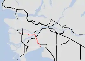 Highway 91 highlighted in red. | ||||
| Route information | ||||
| Length | 23 km[1] (14 mi) | |||
| Existed | 1986–present | |||
| Major junctions | ||||
| South end | ||||
Knight Street in Richmond | ||||
| West end | ||||
| Location | ||||
| Major cities | Richmond, Delta | |||
| Highway system | ||||
British Columbia provincial highways
| ||||

It was the highest numbered highway in British Columbia that is not derived from a continuation of a US highway, until the designation of Highway 118 in 2003.
Route description
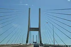
The total distance covered by Highway 91 is 22 km (14 mi). Starting at its junction with Highway 99 in East Delta, the route travels north for 2 km (1¼ mi) to a junction with Highway 10, then north for 10 km (6 mi) through three interchanges, over the Alex Fraser Bridge onto Annacis Island, and through another interchange. Highway 91 then crosses the Annacis Channel bridge, ever so briefly passing through the very corner of New Westminster, and then enters Richmond, at which point it veers west. At the southern entrance to Highway 91, the road is named Annacis Highway, however, that name is not commonly used.
In Richmond, where Highway 91 is officially termed the Richmond Freeway but also as the East-West Connector, the route travels west for 10 more km (6 mi), through a junction with Highway 91A and two more interchanges, until it terminates just past its Richmond junction with Highway 99 at Shell Road.[2]
History
Recent improvements
$10 million had been allocated to convert the existing seagull intersection at 72nd Avenue to an interchange; this junction was in 2009 the only at-grade intersection on Highway 91.[3] Upgrading this interchange would earn Highway 91 the status of a full freeway, but it was reported in the Surrey Leader in 2008 that work on this proposal had ground to a halt because of disagreements between the municipal and provincial governments over the type of interchange that would be in place. The allocated funding had since been diverted for other uses, and as of 2011 the province had no intention of building the interchange,[4] but in April 2013, International Trade Minister Ed Fast announced that the removal of the traffic signal at 72nd Avenue would be given the go-ahead.[5] On June 8, 2016, the BC government announced that the construction of a new interchange at 72nd Avenue, priced at $30 million, would commence in the fall, thereby removing the final traffic signals on Highway 91.[6][7][8] Construction commenced in late 2016. On August 12, 2018, the new interchange opened to remove the final traffic light on Highway 91.[9]
In early 2009, another interchange was agreed upon to be added to Highway 91 just south of the 'S' curve in Richmond, connecting Nelson Road to the highway. The interchange was opened on August 22, 2011.[10][11]
On January 19, 2017, announcement was made that a new seventh travel lane will be added on Alex Fraser Bridge by slightly narrowing the existing lanes and removing the shoulders.[12] A counterflow system with movable barrier was added to help ease traffic during morning and afternoon rush hours. The new seventh lane opened to traffic on September 14, 2019,[13] with the moveable reversible zipper in operation on December 16, 2019.[14] As a result of narrower travel lanes, the maximum speed limit over the bridge was lowered from 90 km/h (56 mph) to 70 km/h (43 mph).[15]
Exit list
From south to north. The entire route is in Metro Vancouver.
| Location | km[1] | mi | Exit[16] | Destinations | Notes |
|---|---|---|---|---|---|
| Delta | 0.00 | 0.00 | |||
| 2.02 | 1.26 | 1 | No access from northbound Hwy 91 to westbound Ladner Trunk Road | ||
| 4.90 | 3.04 | 4 | 64th Avenue | ||
| 6.53 | 4.06 | 6 | 72nd Avenue | ||
| 7.93 | 4.93 | 8 | Nordel Way (east) | Access to Hwy 17 via Hwy 91 Connector | |
| 8.32– 10.85 | 5.17– 6.74 | Alex Fraser Bridge over the South Arm Fraser River | |||
| 11.04 | 6.86 | 10 | Annacis Island (Cliveden Avenue) | Southbound exit is via exit 11 | |
| Richmond | 11.82 | 7.34 | 11 | Directional signage changes from north-south to east-west | |
| 13.31 | 8.27 | 13 | Westminster Highway | ||
| 16.33 | 10.15 | 15 | Nelson Road | Eastbound exit and westbound entrance | |
| 20.82 | 12.94 | 21 | No. 6 Road | Westbound exit and eastbound entrance | |
| 21.22 | 13.19 | 22 | Knight Street – Vancouver | Access to Knight Street northbound only | |
| 22.91 | 14.24 | 23 | Victoria and Nanaimo are via BC Ferries | ||
| — | Alderbridge Way – Richmond City Centre | Continues west | |||
| 1.000 mi = 1.609 km; 1.000 km = 0.621 mi | |||||
Highway 91 Connector
| Highway 91 Connector Highway 91C Pseudo Route 914:3142 (E/B) Pseudo Route 914:3143 (W/B) | |
| Length: | 2.2 km (1.4 mi) |
|---|---|
| West end: | 96 Street at BNSF level crossing |
| Major junctions: | |
| East end: | Nordel Way at BNSF overpass |
Highway 91 Connector (Highway 91C) is a short 2.2 km (1.4 mi) unsigned highway connecting Highway 91 at Nordel Way and Highway 17 in Delta.[17] Stating at the BNSF Railway level crossing on 96 Street, the route continues east towards Highway 17, crossing over Highway 91, then ends at the BNSF overpass on Nordel Way.
The route constantly faces heavy congestion due to the presence of truck scale and at-grade intersections, despite the high traffic volumes the route carries. The Highway 17 and Highway 91C intersection saw several truck rollover accidents since its opening in 2013 and engineer's report revealed that trucks are susceptible to rollover when exceeding 26 km/h (16 mph) while turning from Highway 17 to Highway 91C.[18] The report recommended installation of truck rollover warning sign and an advisory speed limit of 20 km/h (12 mph) with the ultimate long-term solution to be an upgrade to grade-separated interchange.[18]
In 2017, the Province announced Highway 91C will be upgraded to a freeway standard as a part of $254 million project.[19] However, the project was partially downscaled and at-grade intersection will remain at Highway 91/91C interchange. The grade separation work on Highway 91C started in 2020 and free-flow interchanges will be constructed at Highway 17 and Nordel Way (west) with improved partially at-grade connections for Highway 91 ramps.[20] The project is anticipated to reach substantial completion by the end of November 2022 with remaining works extending up to May 2023.[21]
Major intersections
From west to east. The entire route is in Metro Vancouver.
| Location | km[17] | mi | Destinations | Notes | |
|---|---|---|---|---|---|
| Delta | 0.00 | 0.00 | 96 Street | Continues west | |
| 0.25 | 0.16 | River Road (Under Construction) | At-grade, traffic signals; interchange under construction; completion slated for November 2022[21] | ||
| 1.05 | 0.65 | Nordel Way (west) / Scale Access | At-grade, traffic signals; interchange under construction; completion slated for April 2023[21] | ||
| 1.33 | 0.83 | At-grade | |||
| 1.96 | 1.22 | At-grade, traffic signals | |||
| 2.24 | 1.39 | Nordel Way (east) | Continues east | ||
| 1.000 mi = 1.609 km; 1.000 km = 0.621 mi | |||||
References
- Landmark Kilometre Inventory (PDF). British Columbia Ministry of Transportation and Infrastructure (Report). Cypher Consulting. July 2016. pp. 399–402. Archived from the original (PDF) on 2017-03-11. Retrieved 2017-01-04.
- "Official Numbered Routes in British Columbia - Highway 91". BC Ministry of Transportation. 28 May 2008. Retrieved 7 September 2009.
- "$211 million Canada-BC investment at BC lower Mainland crossings". Infrastructure Canada. 30 December 2009. Archived from the original on 6 October 2011. Retrieved 7 September 2009.
- Dave White (29 August 2011). "Delta wants federal cash for highways". News 1130. Archived from the original on 23 March 2012. Retrieved 3 September 2011.
- Jennifer Saltman (3 April 2013). "Hwy 91: Trouble traffic light gets the green for removal". The Province. Archived from the original on 2013-06-30. Retrieved 5 April 2013.
- "Provincial government announces new interchange for 72nd Ave at Hwy 91". News 1130. 8 June 2016.
- "Highway 91 at 72nd Avenue - Interchange Project". Ministry of Transportation and Infrastructure. Province of British Columbia. Retrieved January 4, 2017.
- Smith, James (November 16, 2016). "Construction to start on interchange in Delta at Highway 91 and 72nd Avenue". Peace Arch News. Retrieved January 4, 2017.
- Bernard, Renee; James, Tim (August 12, 2018). "Overpass in Delta replaces traffic lights on Highway 91". News 1130. Retrieved August 13, 2018.
- "Nelson road opening helps truckers, farmers and drivers". Infrastructure Canada. 22 August 2011. Retrieved 25 August 2011.
- Matthew Hoekstra (22 August 2011). "Nelson Road interchange opens today". Richmond Review. Archived from the original on 21 July 2012. Retrieved 25 August 2011.
- Judd, Amy. "New lane to be added to Alex Fraser Bridge by narrowing existing lanes". Global News. Retrieved 2017-02-18.
- Seventh lane now open on Alex Fraser Bridge
- Alex Fraser counterflow lane sees first rush hour commute since opening
- Alex Fraser Bridge speed limit permanently lowered to 70 km/hr
- "Highway Exits & Landmarks". Ministry of Transportation and Infrastructure. Province of British Columbia. Archived from the original on July 15, 2016. Retrieved January 4, 2017.
- "Landmark Kilometre Inventory July 2019 Version" (PDF). Ministry of Transportation and Infrastructure.
- Ponzini, Maurizio (2015-03-18). "Highway 17 & Highway 91 Connector Intersection - Truck Rollover Safety Assessment" (PDF). R.F. Binnie & Associates.
- "Major roadway upgrades in Surrey and Delta to provide economic boost". BC Gov News. Government of British Columbia. 2017-03-10.
- "Highway 91/17 Upgrade Project" (PDF). BCMoT.
- "Highway 91/17 Upgrade Project MONTHLY STATUS REPORT" (PDF). Province of British Columbia. September 30, 2020. p. 8.