Brooks, Oregon
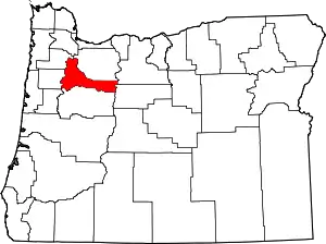
Brooks is an unincorporated community in Marion County, Oregon, United States.[3] For statistical purposes, the United States Census Bureau has defined Brooks as a census-designated place (CDP). The census definition of the area may not precisely correspond to local understanding of the area with the same name. As of the 2010 census the population was 398.[4] Brooks is part of the Salem Metropolitan Statistical Area.
Brooks, Oregon | |
|---|---|
Census-designated place (CDP) | |
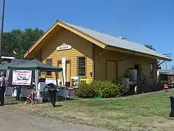
 Brooks' historic railroad depot | |
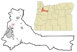
 Location of Brooks, Oregon | |
| Coordinates: 45°3′3″N 122°57′18″W | |
| Country | United States |
| State | Oregon |
| County | Marion |
| Area | |
| • Total | 0.5 sq mi (1.3 km2) |
| • Land | 0.5 sq mi (1.3 km2) |
| • Water | 0.0 sq mi (0.0 km2) |
| Elevation | 184 ft (56 m) |
| Population (2010)U.S. Census | |
| • Total | 398 |
| • Density | 807.0/sq mi (311.6/km2) |
| Time zone | UTC-8 (Pacific (PST)) |
| • Summer (DST) | UTC-7 (PDT) |
| ZIP code | 97305 |
| Area code(s) | 503 and 971 |
| FIPS code | 41-08750[1] |
| GNIS feature ID | 1118111[2] |
It is located about nine miles north of Salem near Oregon Route 99E on French Prairie.[5]
History
Brooks was a station on the Southern Pacific Railroad main line (now the Union Pacific) through the Willamette Valley.[6] The station was named for early settler Linus Brooks, who came to Oregon from Illinois in 1850.[6] He was born in Ohio in 1805.[6] Brooks post office was established in 1871, about the time the railroad reached the community.[6] Brooks was platted with 30 blocks in 1878 and had 135 residents at that time.[7][8] The community did not grow appreciably and it never incorporated.[8]
Geography
According to the United States Census Bureau, the CDP has a total area of 0.5 square miles (1.3 km2), all of it land.[9]
Demographics
As of the census[1] of 2000, there were 410 people, 152 households, and 112 families residing in the CDP. The population density was 807.0 people per square mile (310.4/km2). There were 158 housing units at an average density of 311.0 per square mile (119.6/km2). The racial makeup of the CDP was 82.68% White, 0.24% African American, 1.22% Native American, 0.24% Pacific Islander, 15.12% from other races, and 0.49% from two or more races. Hispanic or Latino of any race were 22.20% of the population.
There were 152 households, out of which 30.3% had children under the age of 18 living with them, 59.9% were married couples living together, 9.9% had a female householder with no husband present, and 25.7% were non-families. 24.3% of all households were made up of individuals, and 11.2% had someone living alone who was 65 years of age or older. The average household size was 2.70 and the average family size was 3.19.
In the CDP, the population was spread out, with 26.1% under the age of 18, 9.3% from 18 to 24, 28.5% from 25 to 44, 20.0% from 45 to 64, and 16.1% who were 65 years of age or older. The median age was 35 years. For every 100 females, there were 104.0 males. For every 100 females age 18 and over, there were 95.5 males.
The median income for a household in the CDP was $25,938, and the median income for a family was $26,318. Males had a median income of $27,375 versus $18,750 for females. The per capita income for the CDP was $12,008. About 12.1% of families and 10.4% of the population were below the poverty line, including 10.4% of those under age 18 and 18.9% of those age 65 or over.
Economy
For planning purposes, Brooks and the community of Hopmere together form an Urban Unincorporated Community, as designated by Marion County.[7] The area's economy has been traditionally based on agriculture.[7] NORPAC, a fruit and vegetable processor, is the largest industrial property in Brooks.[7] Covanta Energy runs a waste-to-energy garbage burning facility in Brooks that handles municipal solid waste from around the county.[7][10]
Museums and other points of interest
Brooks is the home of the transportation museum Antique Powerland.[11] The Brooks Historical Society is located in the former Brooks Southern Pacific railroad depot on the Antique Powerland property.[12]
Education
Brooks is served by the Gervais School District, which includes the grade 2-4 Brooks Elementary School. Students from Brooks attend middle and high school in Gervais. Brooks also is the home of the private Willamette Valley Christian School. The Chemeketa Community College Brooks campus specializes in training of public safety students and professionals.[13]
Notable people
- George Schoener, rose breeder
References
- "U.S. Census website". United States Census Bureau. Retrieved 2008-01-31.
- "US Board on Geographic Names". United States Geological Survey. 2007-10-25. Retrieved 2008-01-31.
- "Brooks". Geographic Names Information System. United States Geological Survey. November 28, 1980. Retrieved 2011-02-15.
- United States Census
- Oregon Atlas & Gazetteer (7th ed.). Yarmouth, Maine: DeLorme. 2008. p. 28. ISBN 0-89933-347-8.
- McArthur, Lewis A.; McArthur, Lewis L. (2003) [1928]. Oregon Geographic Names (7th ed.). Portland, Oregon: Oregon Historical Society Press. p. 115. ISBN 978-0875952772.
- "Brooks-Hopmere Community Plan". Marion County, Oregon. Archived from the original on 2011-07-23. Retrieved 2011-02-15.
- Lowry, Robert; Kenneth Munford; Harriet Moore (1979). "Railroading in the Lower Willamette Valley". Benton County Historical Society and Museum. Archived from the original on 2010-12-13. Retrieved 2011-02-15.
- "US Gazetteer files: 2010, 2000, and 1990". United States Census Bureau. 2011-02-12. Retrieved 2011-04-23.
- "Marion County Waste-To-Energy Facility Information". Marion County, Oregon. Archived from the original on 2011-07-23. Retrieved 2011-02-15.
- Friedman, Ralph (1990). In Search of Western Oregon (2nd ed.). Caldwell, Idaho: The Caxton Printers, Ltd. p. 474. ISBN 0-87004-332-3.
- "History". Brooks Historical Society. Retrieved 2011-02-15.
- "Chemeketa Brooks". Chemeketa Community College. Archived from the original on 2010-10-06. Retrieved 2011-02-15.
External links
- Historic images of Brooks from Salem Public Library
- Brooks Historical Society
- Images of Brooks from Flickr

