Brzozów County
Brzozów County (Polish: powiat brzozowski) is a unit of territorial administration and local government (powiat) in Subcarpathian Voivodeship, south-eastern Poland. It came into being on January 1, 1999, as a result of the Polish local government reforms passed in 1998. Its administrative seat and only town is Brzozów, which lies 38 kilometres (24 mi) south of the regional capital Rzeszów.
Brzozów County
Powiat brzozowski | |
|---|---|
 Flag  Coat of arms | |
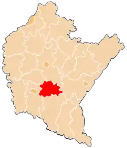 Location within the voivodeship | |
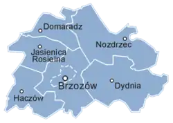 Division into gminas | |
| Coordinates (Brzozów): 49°41′43″N 22°1′10″E | |
| Country | |
| Voivodeship | |
| Seat | Brzozów |
| Gminas | |
| Area | |
| • Total | 540.39 km2 (208.65 sq mi) |
| Population (2019) | |
| • Total | 65,652 |
| • Density | 120/km2 (310/sq mi) |
| • Urban | 7,463 |
| • Rural | 58,189 |
| Car plates | RBR |
| Website | http://www.powiatbrzozow.pl/ |
The county covers an area of 540.39 square kilometres (208.6 sq mi). As of 2019 its total population is 65,652, out of which the population of Brzozów is 7,463, and the rural population is 58,189.[1]
Neighbouring counties
Brzozów County is bordered by Rzeszów County to the north, Przemyśl County to the east, Sanok County to the south-east, Krosno County to the west and Strzyżów County to the north-west.
Administrative division
The county is subdivided into six gminas (one urban-rural and five rural). These are listed in the following table, in descending order of population.
| Gmina | Type | Area (km²) |
Population (2019) |
Seat |
| Gmina Brzozów | urban-rural | 103.2 | 26,653 | Brzozów |
| Gmina Haczów | rural | 71.3 | 9,114 | Haczów |
| Gmina Nozdrzec | rural | 121.6 | 8,047 | Nozdrzec |
| Gmina Dydnia | rural | 130.0 | 7,910 | Dydnia |
| Gmina Jasienica Rosielna | rural | 57.6 | 7,828 | Jasienica Rosielna |
| Gmina Domaradz | rural | 56.7 | 6,100 | Domaradz |
References
- GUS. "Population. Size and structure and vital statistics in Poland by territorial divison in 2019. As of 30th June". stat.gov.pl. Retrieved 2020-09-14.
Seat: Brzozów | ||
| Urban-rural gmina | ||
| Rural gminas | ||
| City counties |
|  |
|---|---|---|
| Land counties | ||