Kolbuszowa County
Kolbuszowa County (Polish: powiat kolbuszowski) is a unit of territorial administration and local government (powiat) in Subcarpathian Voivodeship, south-eastern Poland. It came into being on January 1, 1999, as a result of the Polish local government reforms passed in 1998. Its administrative seat and only town is Kolbuszowa, which lies 30 kilometres (19 mi) north-west of the regional capital Rzeszów.
Kolbuszowa County
Powiat kolbuszowski | |
|---|---|
_-_DSC04617_v3.jpg.webp) Kolbuszowa County Governor's Office | |
 Flag  Coat of arms | |
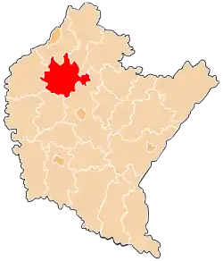 Location within the voivodeship | |
| Coordinates (Kolbuszowa): 50°15′N 21°46′E | |
| Country | |
| Voivodeship | |
| Seat | Kolbuszowa |
| Gminas | |
| Area | |
| • Total | 773.93 km2 (298.82 sq mi) |
| Population (2019) | |
| • Total | 62,389 |
| • Density | 81/km2 (210/sq mi) |
| • Urban | 9,075 |
| • Rural | 53,314 |
| Car plates | RKL |
| Website | http://www.powiat.kolbuszowski.pl/ |
The county covers an area of 773.93 square kilometres (298.8 sq mi). As of 2019 its total population is 62,389, out of which the population of Kolbuszowa is 9,075, and the rural population is 53,314.[1]
Neighbouring counties
Kolbuszowa County is bordered by Tarnobrzeg County and Stalowa Wola County to the north, Nisko County to the north-east, Rzeszów County to the south-east, Ropczyce-Sędziszów County to the south, and Mielec County to the west.
Administrative division
The county is subdivided into six gminas (one urban-rural and five rural). These are listed in the following table, in descending order of population.
| Gmina | Type | Area (km²) |
Population (2019) |
Seat |
| Gmina Kolbuszowa | urban-rural | 170.6 | 24,795 | Kolbuszowa |
| Gmina Majdan Królewski | rural | 155.8 | 9,865 | Majdan Królewski |
| Gmina Cmolas | rural | 134.1 | 8,124 | Cmolas |
| Gmina Raniżów | rural | 96.8 | 7,047 | Raniżów |
| Gmina Dzikowiec | rural | 121.7 | 6,490 | Dzikowiec |
| Gmina Niwiska | rural | 95.2 | 6,068 | Niwiska |
References
- GUS. "Population. Size and structure and vital statistics in Poland by territorial divison in 2019. As of 30th June". stat.gov.pl. Retrieved 2020-09-14.
| Seat | | |
|---|---|---|
| Urban-rural gmina | ||
| Rural gminas | ||
| City counties |
|  |
|---|---|---|
| Land counties | ||
