Burwell, Cambridgeshire
Burwell /ˈbɜːrwɛl/ is a village and civil parish in Cambridgeshire, England, some 10 miles (16 km) north-east of Cambridge.[3] It lies on the south-east edge of the Fens. Westward drainage is improved by Cambridgeshire lodes (waterways), including Burwell Lode, a growth factor in the village. A population of 6,309 in the 2011 census was put at 6,417 in 2019.[4]
| Burwell | |
|---|---|
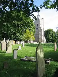
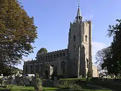 St. Mary's Church in Burwell, a Grade I listed building dating from the 12th century. | |
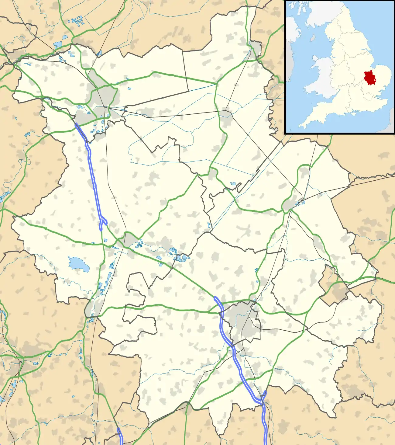 Burwell Location within Cambridgeshire | |
| Area | 24.7 km2 (9.5 sq mi) [1] |
| Population | 6,309 (2011)[2] |
| • Density | 255/km2 (660/sq mi) |
| OS grid reference | TL589665 |
| • London | 56.6 mi (91.1 km) SSW |
| Civil parish |
|
| District | |
| Shire county | |
| Region | |
| Country | England |
| Sovereign state | United Kingdom |
| Post town | Cambridge |
| Postcode district | CB25 |
| Dialling code | 01638 |
| Police | Cambridgeshire |
| Fire | Cambridgeshire |
| Ambulance | East of England |
| UK Parliament | |
| Website | Parish Council |
History
Etymology
The name "Burwell" is of Anglo-Saxon origin and refers to a fort (burh-) located close to a spring (-well).[5] The first record of the name in the area dates from 1060[6] and the village is recorded in the Domesday Book under the spellings Burewelle, Burwella and Burwelle.[7] A spring is situated in the south of the village close to the remains of the 12th-century Burwell Castle,[5] although there is evidence of previous settlement on or near the castle site.[8]
Old maps sometimes label the village as the plural "Burwells",[9][10] which may refer to a pair of villages, Burwell St Mary[11][12] and Burwell St Andrew,[13] or to the split between the High Town around the churches in the south of the village and the newer North Street and Newnham parts of the village, which were separated by a causeway.[5]
Early settlement
There is evidence of human activity in the vicinity of Burwell since prehistory. Flint tools including axes dating from the Palaeolithic[14] and Mesolithic[15] have been found on the west side of the village. Further burned and worked flint has been found close to the spring dating from the late Neolithic,[16] but the majority of activity in the area at the time seemed to be on the actual Fen to the west of the village, where the discovery of a large number of flint and stone tools on a raised piece of ground suggests that there was already settlement in the parish before the onset of the Bronze Age.[17] During the Neolithic, peat had begun to form on the fens around the village which has partly buried prehistoric sites.[6]
Activity on the fen continued into the Bronze Age,[18][19] as did activity close to the spring[20] but they were joined by increasing activity on the heath in the south of the parish, where barrows are known to have existed.[21] The southern part of the parish is also the highest ground within it, and is close to the ancient Icknield Way.[22]
As Burwell entered the Iron Age, activity on the fens to the west of the village appears to have diminished, since the conditions became more marshy. However, ditch systems and enclosures were found during excavations in 1969 and 1995 in the west of the parish.[23] Activity in proximity to the spring continued with evidence discovered for a burial in a nearby ditch[16] and a settlement was uncovered in 2005 on the eastern edge of the village.[24]
Settlement close to the spring continued after Roman colonisation of Britain, as evidence for a Roman settlement has been found 500 yards north of St Mary's Church.[25] Various Roman archaeology has been found around the village, including pottery,[26] a hoard of vessels and bowls,[27] a lead vat,[28] and coins possibly relating to a villa on Ness Road, north of the village.[29] Evidence for another villa in the same area comes from roof tiles dating from the 2nd century[30] although the findings around the village cover the 2nd – 4th centuries. Reach Lode on the north-west edge of the parish is likely to be of Roman construction,[31] as was the original Burwell Lode which has since been replaced[32]
Early history
The village is located at the head of Burwell Lode, a man-made waterway which connects it with the River Cam. The present course, created in the mid-17th century, replaced an older route which was probably Roman in origin.[33] The lode splits into two at the village, and each branch served a series of basins, warehouses and wharves, which were located at the bottom of long strips of land, with the merchants' houses at the other end of them.[34]
The village and the lode became more important with the opening in the 1850s of the Burwell Chemical Works, owned by T. T. Ball. By the 1890s, it had become the Patent Manure Works, was owned by Colchester and Ball, and about 10,000 tons of goods each year were shipped along the lode, using three steam tugs and a large fleet of lighters. Prentice Brothers Ltd built barges in the village until 1920, and continued repairing them there after they bought the fertiliser factory in 1921. The factory was later owned by Fisons, and boats continued to be used to move the fertiliser to Fenland farms until 1948. Commercial use of the lode ceased in 1963, when the traffic in sugar beet stopped.[33]
Burwell Castle
The village is the site of an unfinished castle, situated in Spring Close.[nb 1] The final wall was knocked down by the Fire Brigade testing a fire hose in the 1930s, but the dry moat is still clearly visible. The castle was built during "The Anarchy", the internal conflict of the mid-12th century in the reign of King Stephen. Although a settlement had been reached such that the throne would pass to Henry II on Stephen's death, the Barons of the time took the opportunity to fight their own battles.
Among these Geoffrey de Mandeville was particularly troublesome and, after turning against Stephen, had set up an impregnable base around Ely. From his base he would attack local towns, such as Cambridge, and so the king ordered castles be built to surround Geoffrey. The few sites at which it is known such castles were to be constructed include Rampton (Giant's Hill), Ramsey (Booth's Hill), Burwell, and possibly Knapwell.
At Burwell, a moat had been constructed and the stone keep partially built when Geoffrey attacked and was mortally wounded. His revolt thus collapsed and the castle was left unfinished. The narrow lane running along the side of the church next to Spring Close, where the Castle is located, is named "Mandeville".
Barn Fire
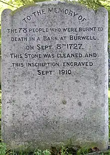
On 8 September 1727, a puppet show visited Burwell and put on a show, held in a barn on what is now Cuckolds Row, near the centre of the village. After the barn had filled with an audience from Burwell and surrounding villages, the doors were nailed shut to prevent further people getting in, a simple act which was key to the tragedy which resulted.
One person who could not get into the barn sat with a candle lantern and peered in to watch the show. However, the person accidentally knocked the lantern into the barn, setting fire to the hay within. With no way to escape, 78 people (51 of them, children) perished in the ensuing blaze.
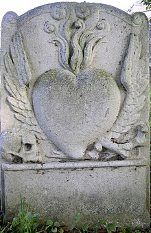
The deceased are buried in the churchyard of St Mary's parish church, at the opposite end of the High Street, with a gravestone engraved with a blazing heart with angels' wings. On 8 September 2005, a plaque was unveiled at the site of the barn in memorial of the fire.[35]
The Ipswich Journal of 26 February 1774 reported that "an old man who died recently near Newmarket who just before his death confessed that he set fire to a barn at Burwell, Cambridgeshire on the 8th of September 1727 when no less than 80 persons lost their lives and that having an antipathy to the puppet showman was the cause of him committing the action."[36]
Governance
Burwell is a parish and thus has a parish council to deal with matters within the village. These include the maintenance and provision of both village halls, the recreation ground, playgrounds, and allotments. The Parish Council convenes at the Jubilee Reading Room on The Causeway.[37]
Burwell parish falls within Burwell ward and provides three councillors[38] to the local East Cambridgeshire District Council which convenes at The Grange in Ely. A larger Burwell electoral division also provides one councillor[39] to Cambridgeshire County Council which convenes at Shire Hall in Cambridge.
The village falls within the South East Cambridgeshire constituency, which has been a Conservative stronghold since formation in 1983. James Paice became the local MP in 1987 and held his seat at the 2010 general election. His predecessor as local MP, Francis Pym, served as Foreign Secretary between the Falklands War and the 1983 general election and lived in the village.[40]
Local government boundaries have varied somewhat over the years. At a parish level, the boundary followed Devil's Dyke through the neighbouring village of Reach bisecting it until it was formed into a new parish in 1961.[5] The other boundaries of the parish have also changed slightly several times over the years, most obviously on the south-eastern edge, where part of the Parish including part of Newmarket Racecourse[41] was lost to Newmarket when the boundary was adjusted to follow the A14 bypass in 1993.[42] The boundaries with Newmarket and Exning parishes are also the boundary between the county of Cambridgeshire and neighbouring Suffolk.
As with the rest of England, a system of Hundreds used to cover Cambridgeshire until the 19th century. Burwell covered the south-western edge of the Staploe Hundred, which also included the nearby parishes of Chippenham, Fordham, Isleham, Kennett, Landwade, Snailwell, Soham and Wicken.
East Cambridgeshire District Council only came into being in 1974 with the Local Government Act 1972. Before the reorganisation, Burwell fell inside the Newmarket Rural District which had existed since 1894. Between 1875 and 1894, this was part of a larger Newmarket Rural Sanitary District which also encompassed the Moulton Rural District in neighbouring West Suffolk.
The boundaries of Cambridgeshire itself have also changed somewhat over the years, with the current county only coming into effect in 1974, in the same 1972 Act which created East Cambridgeshire district. Before Huntingdon and Peterborough joined the county in 1974, Burwell fell within Cambridgeshire and Isle of Ely which covered the southern and eastern parts of the modern county. Between 1888 and 1965, the village also fell within a smaller administrative county of Cambridgeshire, covering only the southern part of the modern county.
Geography
Places adjacent to Burwell, Cambridgeshire | |
|---|---|
Climate
| Climate data for Cambridge University Botanic Garden[lower-alpha 1], elevation: 13 m (43 ft), 1981–2010 normals, extremes 1914–present | |||||||||||||
|---|---|---|---|---|---|---|---|---|---|---|---|---|---|
| Month | Jan | Feb | Mar | Apr | May | Jun | Jul | Aug | Sep | Oct | Nov | Dec | Year |
| Record high °C (°F) | 14.9 (58.8) |
18.8 (65.8) |
23.9 (75.0) |
27.4 (81.3) |
31.1 (88.0) |
34.0 (93.2) |
38.7 (101.7) |
36.9 (98.4) |
33.9 (93.0) |
29.3 (84.7) |
21.1 (70.0) |
15.8 (60.4) |
38.7 (101.7) |
| Average high °C (°F) | 7.4 (45.3) |
8.0 (46.4) |
11.1 (52.0) |
13.8 (56.8) |
17.5 (63.5) |
20.4 (68.7) |
23.1 (73.6) |
22.8 (73.0) |
19.6 (67.3) |
15.2 (59.4) |
10.5 (50.9) |
7.7 (45.9) |
14.8 (58.6) |
| Daily mean °C (°F) | 4.4 (39.9) |
4.6 (40.3) |
7.1 (44.8) |
9.1 (48.4) |
12.4 (54.3) |
15.3 (59.5) |
17.8 (64.0) |
17.5 (63.5) |
14.8 (58.6) |
11.2 (52.2) |
7.2 (45.0) |
4.7 (40.5) |
10.5 (50.9) |
| Average low °C (°F) | 1.4 (34.5) |
1.2 (34.2) |
3.0 (37.4) |
4.3 (39.7) |
7.3 (45.1) |
10.2 (50.4) |
12.4 (54.3) |
12.2 (54.0) |
10.0 (50.0) |
7.2 (45.0) |
3.9 (39.0) |
1.7 (35.1) |
6.2 (43.2) |
| Record low °C (°F) | −16.1 (3.0) |
−17.2 (1.0) |
−11.7 (10.9) |
−6.1 (21.0) |
−4.4 (24.1) |
−0.6 (30.9) |
2.2 (36.0) |
3.3 (37.9) |
−2.2 (28.0) |
−6.1 (21.0) |
−13.3 (8.1) |
−15.6 (3.9) |
−17.2 (1.0) |
| Average precipitation mm (inches) | 46.0 (1.81) |
34.6 (1.36) |
38.6 (1.52) |
40.3 (1.59) |
46.7 (1.84) |
52.1 (2.05) |
50.7 (2.00) |
53.6 (2.11) |
54.3 (2.14) |
57.7 (2.27) |
54.9 (2.16) |
46.9 (1.85) |
576.2 (22.69) |
| Average precipitation days (≥ 1.0 mm) | 10.7 | 8.4 | 9.9 | 8.9 | 8.1 | 9.2 | 8.4 | 8.2 | 8.4 | 9.5 | 10.2 | 9.7 | 109.6 |
| Source: KNMI[43] | |||||||||||||
| Climate data for Cambridge NIAB[lower-alpha 2], elevation: 26 m (85 ft), 1981–2010 normals | |||||||||||||
|---|---|---|---|---|---|---|---|---|---|---|---|---|---|
| Month | Jan | Feb | Mar | Apr | May | Jun | Jul | Aug | Sep | Oct | Nov | Dec | Year |
| Average high °C (°F) | 7.3 (45.1) |
7.7 (45.9) |
10.6 (51.1) |
13.3 (55.9) |
16.9 (62.4) |
19.9 (67.8) |
22.8 (73.0) |
22.6 (72.7) |
19.3 (66.7) |
14.9 (58.8) |
10.3 (50.5) |
7.5 (45.5) |
14.5 (58.1) |
| Daily mean °C (°F) | 4.5 (40.1) |
4.5 (40.1) |
6.9 (44.4) |
8.8 (47.8) |
12.0 (53.6) |
15.1 (59.2) |
17.6 (63.7) |
17.5 (63.5) |
14.9 (58.8) |
11.3 (52.3) |
7.3 (45.1) |
4.7 (40.5) |
10.4 (50.7) |
| Average low °C (°F) | 1.6 (34.9) |
1.3 (34.3) |
3.1 (37.6) |
4.3 (39.7) |
7.1 (44.8) |
10.2 (50.4) |
12.4 (54.3) |
12.4 (54.3) |
10.4 (50.7) |
7.6 (45.7) |
4.2 (39.6) |
1.9 (35.4) |
6.4 (43.5) |
| Average precipitation mm (inches) | 46.6 (1.83) |
34.5 (1.36) |
38.3 (1.51) |
41.2 (1.62) |
46.0 (1.81) |
51.5 (2.03) |
47.5 (1.87) |
50.8 (2.00) |
53.5 (2.11) |
59.0 (2.32) |
52.8 (2.08) |
46.4 (1.83) |
568.1 (22.37) |
| Average precipitation days (≥ 1.0 mm) | 10.5 | 8.0 | 9.6 | 8.8 | 8.0 | 8.9 | 8.3 | 8.0 | 8.4 | 9.4 | 9.8 | 9.8 | 107.5 |
| Mean monthly sunshine hours | 58.3 | 77.1 | 110.7 | 152.5 | 179.4 | 176.7 | 187.6 | 182.6 | 139.5 | 113.9 | 66.7 | 49.3 | 1,494.5 |
| Source: Met Office[44] | |||||||||||||
Clunch quarry
Up until the early 20th century the building material known as clunch (a soft rock which is one type of chalk limestone) was dug in Burwell. Remains of the open quarry can be seen either side of Bloomsfield. Clunch was used to build many of the houses in Burwell and remains the name of the local community magazine.
Priory Wood
Burwell has a small area of woodland. Planted in 1998 as a community project to commemorate the coming millennium, it is owned and maintained by the Woodland Trust. The official name comes from an ancient priory which stood nearby also giving its name to some of the local roads, such as Priory Close and Abbey Close.[45]
Population
| Historical population of Burwell[nb 2] | |||||||||||
| Year | 1801 | 1811 | 1821 | 1831 | 1841 | 1851 | 1861 | 1871 | 1881 | 1891 | 1901 |
|---|---|---|---|---|---|---|---|---|---|---|---|
| Population | 1,250 | 1,324 | 1,518 | 1,668 | 1,820 | 2,187 | 1,987 | 2,106 | 1,949 | 1,998 | 1,974 |
| Year | 1911 | 1921 | 1931 | 1941 | 1951 | 1961 | 1971 | 1981 | 1991 | 2001 | 2011 |
| Population | 2,144 | 2,108 | 2,257 | [nb 3] | 2,364 | 2,734 | 4,032 | 4,257 | 4,531 | 5,833 | 6,309 |
Notable people
In birth order:
- Geoffrey de Mandeville, 1st Earl of Essex (died 1144) was mortally wounded at Burwell in a rebellion against Stephen, King of England.
- Edward Fitzball (born Ball, 1792–1873), London playwright specializing in melodrama, was born in Burwell.
- William Wickins (1862–1933), Anglican Archbishop of Calcutta and Honorary Chaplain to the King, was a curate in Burwell.
- Marjory Stephenson (1885–1948), biochemist specializing in microbial metabolism, grew up in Burwell. She became one of the first two female members of the Royal Society in 1945.
- Eric Ennion (1900–1981), natural historian and broadcaster, had been a GP in Burwell for twenty years.
- Thomas Malcolm Charlton (1923–1997), civil engineer and science historian, retired to Burwell in 1979.
- John Louis Mansi (1926–2010), actor living in Burwell in the 1980s
- Lawrence Harvey (born 1972), former member of the Turks and Caicos Islands national football team, has worked in Burwell as a quantity surveyor.
Culture and community
Carnival
The village hosts an annual carnival in June, which raises money for charity. A parade travels from Margaret Field in the south of the village to the Recreational Ground, where stalls and fairground rides are present.[47]
Twinning
The village is twinned with two villages: Lizy-sur-Ourcq[48] and Mary-sur-Marne and one small town: Ocquerre. These are all situated in France, but only Lizy is mentioned on the signs as you enter the village. Visits from Burwell to the twinned villages are organised by the Burwell Village Twinning Association. A plate commemorating the twinning is located on a wall on the outside of the Year 3 classroom at the village primary school: Burwell Village College (Primary) which educates local four to eleven-year-olds. The village falls within the catchment areas of both Bottisham and Soham Village Colleges, which provide education at secondary school level (11–16 yrs).
Transport
.jpg.webp)
Road access to Burwell is primarily through the B1102 Cambridge to Mildenhall road which runs the length of the village, and from the B1103 which links the village with Newmarket. The A14 passes along the southernmost edge of Burwell parish on the Cambridgeshire–Suffolk border, but cannot be accessed without leaving the parish.
Public transport is provided by Stagecoach in Cambridge bus route 10 running through the village between Cambridge and Newmarket.[49] Stagecoach took over what used to be Cambus in the mid-1990s, Cambus itself having split from the Eastern Counties Omnibus Company in 1984. Eastern Counties absorbed Burwell and District in 1979, the local bus company having provided transport to nearby Cambridge, Newmarket and Bury St Edmunds, and to destinations further afield, such as Great Yarmouth and Felixstowe.[50][51]
Between 1884 and 1965, railway station stood in the south of the village, served by the Cambridge to Mildenhall railway. The station closed to passengers in 1962, and although nothing of it remains, its presence is acknowledged in the names of the streets Railway Close and Station Gate on the site of the former station. There was also a halt on Newmarket Road to the south-east of the village. The B1103 still goes over a railway bridge on the site.[52]
To the north of the village, temporary tramways provided access from the nearby Ipswich to Ely Line to the local brickworks, situated near the Lode.[53]
Burwell Lode is navigable up to the edge of the village at Anchor Lane. The Lode joins Reach Lode in the north-west corner of the parish before they confluence with the River Cam at Upware, 5 miles from Burwell.[54][55]
Education
Burwell contains a nursery,[56] a Montessori[57] and a playgroup[58] for pre-school children. The old school house on the High Street, a listed building dating from 1864, is now a private residence.[59][60]
Children attend Burwell Village College (Primary) up to the age of 11 and then go to secondary schools at either Soham or Bottisham.
Burwell Museum
The museum depicts life through the centuries on the edge of the Cambridgeshire fens.
Opened in 1992, it is housed in a collection of buildings, some reconstructed from other sites, such as the 18th-century timber-framed barn, and others built in the local style using mainly reclaimed materials, such as the wagon sheds/granary display area.
The displays are set out as "scenes" (resembling stage sets) with groups of artefacts making up each display, to give a better idea of how, where and when items were used. Themes and exhibits include agriculture, period rooms and household items, military life, a blacksmith's shop, a reconstruction of a Roman potter's workshop, a Victorian school room, and vintage vehicles, carts and farm equipment.
The museum is a regular venue for school trips. Eight local schoolchildren appeared in 2012 in a TV programme about the Cambridgeshire fens that was filmed here.
The neighbouring Grade II*-listed windmill, Stevens' Mill, forms part of the museum and can be visited when the museum is open. It was probably built about 1820. The mill stayed in the Carter family until 1884, when it was sold to George Mason, who had been the tenant miller. By the 1920s, the mill, which at one time could be powered also by steam, was owned by the Stevens family.[61]
When Warren Stevens retired in 1955, the mill became redundant and fell into disrepair. The Burwell Museum obtained funding of £400,000 from Heritage Lottery Fund for restoring it.[62]
Religion
Church of England
Burwell has a large, Grade I-listed parish church located in the High Street in the south of the village. Dedicated to St Mary the Virgin, the church is in Perpendicular Gothic style and dates back to the 15th century, although some parts are older.[63] It has an active, churchgoing membership of 50–70. The vicar since April 2011 is Rev. Dr Eleanor Williams.
Baptist Church
At the northern end of the village, Burwell has a Baptist church with a membership of around 50. Since May 2015, the minister has been the Rev. Chris Johnson.
Trinity Church
Located near to St Mary's, Trinity is a small church founded by a merger of the Methodist and United Reformed communities in 1988. It has a regular congregation of about 20.
Others
The nearest Roman Catholic church is Our Lady and St Etheldreda in neighbouring Newmarket. The village has a number of former churches converted to other uses. The large cemetery in Ness Road has a small non-denominational chapel.
Sport
Burwell Swifts F.C. play football in Division 1A of the NMC Cambridgeshire Football League, with a reserve team in Division 3B.
Burwell Tigers F.C. play football in Division 5A of the NMC Cambridgeshire Football League.
There are also two youth football clubs; the Burwell Swallows[64] and Burwell Tigers.[65]
Burwell Cricket Club[66] is based on Tan House Lane, with a 1st XI in the East Anglian Premier League.
Media
The village of Burwell is served by media sources that include the community magazine Clunch,[67] dealing with news on a village level. The village is within the catchment area of the Cambridge News and Newmarket Journal newspapers,[68] and the radio stations BBC Radio Cambridgeshire and Heart East. For regional television, Burwell is in the BBC East and ITV Anglia regions. Among several books about the village is the illustrated Memories of Burwell by Frank Czucha published in April 2017, which is available locally.[69]
See also
References
- Office for National Statistics: Land use statistics. Figure for entirety of Burwell ward including surrounding farmland.
- "Key Figures for 2011 Census: Key Statistics. Area: Burwell (Parish)". ONS. 2013. Retrieved 2 February 2013.
- "Burwell". English Church Architecture. Archived from the original on 19 December 2011. Retrieved 13 November 2011.
- [https://www.citypopulation.de/en/uk/eastofengland/cambridgeshire/E34002125__burwell/. City Population. Retrieved 2 January 2021.
- British History Online: 'Burwell', A History of the County of Cambridge and the Isle of Ely: Volume 10: Cheveley, Flendish, Staine and Staploe Hundreds (north-eastern Cambridgeshire) (2002), pp. 334–341. URL: http://www.british-history.ac.uk/report.aspx?compid=18903 Date Retrieved 13 October 2010
- "Cambridgeshire County Council – The Historic Towns of Cambridgeshire: An Extensive Urban Survey: BURWELL, p. 5 Summary" (PDF). Archived from the original (PDF) on 4 March 2012. Retrieved 13 November 2011.
- "Domesday Book". National Archives. Retrieved 13 November 2011.
- Cambridgeshire County Council: Extensive Urban Survey: Burwell Archived 31 January 2009 at the Wayback Machine
- Antique Maps: Cambridgeshire, Jan Jansson, c. 1646 Archived 7 July 2011 at the Wayback Machine showing Burwell as "Burwells"
- Antique Maps: Cambridgeshire, Richard Blome, 1715 Archived 7 July 2011 at the Wayback Machine showing Burwell as "Burwells"
- Antique Maps: Cambridgeshire Archived 7 July 2011 at the Wayback Machine, Emanuel Bowen, 1777, showing Burwell as "Burwell or Burwell St. Mary"
- "A Vision of Britain Through Time: Burwell St Mary". Visionofbritain.org.uk. Archived from the original on 24 December 2012. Retrieved 13 November 2011.
- "A Vision of Britain Through Time: Burwell St Andrew". Visionofbritain.org.uk. Archived from the original on 24 December 2012. Retrieved 13 November 2011.
- "Cambridgeshire HER: Palaeolithic axe find, Burwell Castle". Heritage Gateway. 3 December 1992. Retrieved 13 November 2011.
- "Cambridgeshire HER: Mesolithic axe, Hightown Drove". Heritage Gateway. Retrieved 13 November 2011.
- "Cambridgeshire HER: Prehistoric and Roman remains, Reach Road, Burwell". Heritage Gateway. Retrieved 13 November 2011.
- "Cambridgeshire HER: Probable Neolithic settlement, Hallard's Fen, Burwell". Heritage Gateway. Retrieved 13 November 2011.
- "Cambridgeshire HER: Bronze Age palstave and spear, Burwell". Heritage Gateway. Retrieved 13 November 2011.
- "Cambridgeshire HER: Late Bronze Age hoard, Burwell Fen". Heritage Gateway. Retrieved 13 November 2011.
- "Cambridgeshire HER: Bronze hoard, St Mary's churchyard, Burwell". Heritage Gateway. Retrieved 13 November 2011.
- "Cambridgeshire HER: "The Beacons" Bronze Age barrow". Heritage Gateway. Retrieved 13 November 2011.
- Cambridgeshire County Council – The Historic Towns of Cambridgeshire: An Extensive Urban Survey: BURWELL Archived 4 March 2012 at the Wayback Machine Page 9: "The south-eastern corner of Burwell reaches the ancient Icknield Way." ... "Part of Burwell Heath reaches a height of over 50m in the southern corner of the parish."
- "Cambridgeshire HER: Iron Age ditch systems, Burwell". Heritage Gateway. Retrieved 13 November 2011.
- "Cambridgeshire HER: Iron Age settlement remains, Newmarket Road, Burwell". Heritage Gateway. Retrieved 13 November 2011.
- "Cambridgeshire HER: Roman settlement, N of Burwell Church". Heritage Gateway. Retrieved 13 November 2011.
- "Cambridgeshire HER: Roman finds and features, Burwell". Heritage Gateway. Retrieved 13 November 2011.
- "Cambridgeshire HER: Roman hoard, Burwell". Heritage Gateway. Retrieved 13 November 2011.
- "Cambridgeshire HER: Roman vat, Burwell". Heritage Gateway. Retrieved 13 November 2011.
- "Cambridgeshire HER: Metal detecting finds, High Ness Farm, Burwell". Heritage Gateway. Retrieved 13 November 2011.
- "Cambridgeshire HER: Possible Roman settlement site, Burwell". Heritage Gateway. 26 March 1952. Retrieved 13 November 2011.
- "Cambridgeshire HER: Reach Lode". Heritage Gateway. Retrieved 13 November 2011.
- "Cambridgeshire County Council – The Historic Towns of Cambridgeshire: An Extensive Urban Survey: BURWELL" (PDF). Archived from the original (PDF) on 4 March 2012. Retrieved 13 November 2011.
- The Canals of Eastern England, (1977), John Boyes and Ronald Russell, David and Charles, ISBN 978-0-7153-7415-3
- The River Great Ouse and tributaries, (2006), Andrew Hunter Blair, Imray Laurie Norie and Wilson, ISBN 978-0-85288-943-5
- ""Ceremony to mark tragic blaze" Cambridge Evening News, 13 September 2005". Cambridge-news.co.uk. 28 January 2010. Retrieved 13 November 2011.
- "1773 Ipswich Journal newspaper archive". Retrieved 2 May 2014.
- "Burwell Parish Council". Burwell Parish Council. Retrieved 13 November 2011.
- East Cambridgeshire District Council. "East Cambridgeshire District Council – District Councillors: Burwell Ward". Eastcambs.gov.uk. Retrieved 13 November 2011.
- "Cambridgeshire County Council: 2009 Results, Division View, Burwell Ward". Cambridgeshire.gov.uk. Archived from the original on 4 March 2012. Retrieved 13 November 2011.
- Burke's Peerage: PYM OF HAZELLS HALL "FRANCIS LESLIE PYM, MC (1945), of The Tan House, Burwell, Cambridge..."
- Stredder Family Genealogy. Archived 30 August 2010 at the Wayback Machine Map of Cambridgeshire published 1830 shows "Race courses" partly within the southern edge of Staploe Hundred, in Burwell parish.
- British History: Staploe Hundred 4th para: "At the same time the part of Newmarket Heath at the southern end of Burwell, apparently south of the line of the Newmarket bypass, was also transferred to Suffolk, Burwell's boundary to the north-east of that area being also somewhat straightened."
- "Indices Data - Cambridge (B. Gdns) Station 1639". KNMI. Retrieved 12 March 2019.
- "Cambridge NIAB 1981–2010 averages". Met Office. Retrieved 12 March 2019.
- "Woodland Trust Priory Wood Management Plan 2012-2017" (PDF). Woodland Trust. Retrieved 6 October 2015.
- "Historic Census Population Figures". Cambridgeshire County Council. 2010. Archived from the original (XLS) on 9 June 2011. Retrieved 9 October 2010.
- UK2.NET. "Burwell Carnival". Burwell-carnival.info. Retrieved 13 November 2011.
- "British towns twinned with French towns". Archant Community Media Ltd. Archived from the original on 5 July 2013. Retrieved 11 July 2013.
- "Cambridge Route 10/10A details". Stagecoach Bus. 4 September 2011. Archived from the original on 2 April 2012. Retrieved 13 November 2011.
- "Burwell and District Bus Company". The Cambridge Time Traveller. 9 March 2010. Archived from the original on 8 July 2011. Retrieved 13 November 2011.
- "Burwell & District Motor Service: 1922–1979". Petergould.co.uk. 9 June 1979. Retrieved 13 November 2011.
- "OS Map showing Burwell & Exning Road stations, the latter labelled "Halt"". Npemap.org.uk. Retrieved 13 November 2011.
- "cambridgeshirehistory.com; The Coprolite Industry". Cambridgeshirehistory.com. Archived from the original on 4 April 2016. Retrieved 13 November 2011.
- "Inland Waterways Association: River Cam". Waterways.org.uk. Retrieved 13 November 2011.
- UK Statute Law Database: SCHEDULE 1 TO THE ANGLIAN WATER AUTHORITY ACT 1977 PART 3: 5. (l) applies to Burwell Lode and refers to a navigation authority which is responsible for keeping the Lode navigable.
- "Red House Day Nursery". Cambridgeshire.net. 8 August 2008. Archived from the original on 6 October 2011. Retrieved 13 November 2011.
- "Spring Close Montessori". Ofstedgov.com. Archived from the original on 30 January 2013. Retrieved 13 November 2011.
- "Burwell Early Learners". Cambridgeshire.net. 22 September 2010. Archived from the original on 6 October 2011. Retrieved 13 November 2011.
- "The Old School House 30 High Street Burwell, Cambs CB25 0HB". East Cambridgeshire District Council. Archived from the original on 18 August 2014.
- "10 charming converted schools for sale". The Daily Telegraph.
- "Name: STEVENS MILL List entry Number: 1126407". Historic England. Retrieved 13 January 2018.
- "www.burwellmuseum.org.uk". burwellmuseum.org.uk. Retrieved 13 November 2011.
- "St Mary's Burwell: St Mary's History". Stmarysburwell.org.uk. Retrieved 13 November 2011.
- Burwell Swallows Football Club Archived 5 February 2007 at the Wayback Machine
- Burwell Tigers F.C Archived 28 November 2006 at the Wayback Machine
- "Burwell Cricket Club". Burwell.play-cricket.com. Archived from the original on 10 July 2012. Retrieved 13 November 2011.
- "Clunch". Burwell.co.uk. Retrieved 13 November 2011.
- "Newmarket Journal". Newmarket Journal. 8 July 2011. Retrieved 13 November 2011.
- Bibliography Retrieved 8 September 2017.
Notes
- Weather station is located 0.8 miles (1.3 km) from the Cambridge city centre.
- Weather station is located 3 miles (5 km) from the Cambridge city centre.
Sources
- grid reference TL587661
- Figures up to and including 1951 include the part of Reach formerly in Burwell parish
- No census 1941 due to World War II
External links
| Wikimedia Commons has media related to Burwell, Cambridgeshire. |
- burwell.co.uk
- burwellvillage.net
- Burwell Village College (Primary)
- Burwell Museum
- Burwell Village Twinning Association
- St Mary's Church website
- Cambridgeshire Churches: St Mary's, Burwell
- Baptist Church website

| Authority control |
|
|---|