California Historical Landmarks in Tehama County, California
This list includes properties and districts listed on the California Historical Landmark listing in Tehama County, California. Click the "Map of all coordinates" link to the right to view a Google map of all properties and districts with latitude and longitude coordinates in the table below.
| Image | [1] | Landmark name | Location | City or town | Summary |
|---|---|---|---|---|---|
 First Tehama County Courthouse |
183 | First Tehama County Courthouse | 2nd and D Sts. 40°01′35″N 122°07′17″W |
Tehama | First courthouse in Red Bluff. [2] |
 Home of Mrs. John Brown |
117 | Home of Mrs. John Brown | 135 Main St. 40°10′21″N 122°13′50″W |
Red Bluff | Home of abolitionist John Brown's wife.[3] |
Nomi Lackee Indian Reservation |
357 | Nomi Lackee Indian Reservation | Osborn Rd. 39°57′22″N 122°29′12″W |
Flournoy | Was a 23,000 acres reservation with a fort.[4] |
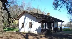 William B. Ide Adobe |
12 | William B. Ide Adobe | William B. Ide Adobe State Historic Park 40°11′50″N 122°13′34″W |
Red Bluff |
References
- "California Historical Landmarks By County". Ohp.parks.ca.gov. Retrieved 2019-04-03.
- cschs.org, Tehama County Courthouse
- .parks.ca.gov, Home of Mrs. John Brown
- nps.gov, Nomi Lackee Indian Reservation
See also
| Wikimedia Commons has media related to California Historical Landmarks in Tehama County, California. |
- List of California Historical Landmarks
- National Register of Historic Places listings in Tehama County, California
This article is issued from Wikipedia. The text is licensed under Creative Commons - Attribution - Sharealike. Additional terms may apply for the media files.