Cambria Township, Blue Earth County, Minnesota
Cambria Township is a township in Blue Earth County, Minnesota, United States. The population was 271 as of the 2000 census.[3]
Cambria Township | |
|---|---|
 Cambria Township Location within the state of Minnesota  Cambria Township Cambria Township (the United States) | |
| Coordinates: 44°13′38″N 94°19′26″W | |
| Country | United States |
| State | Minnesota |
| County | Blue Earth |
| Area | |
| • Total | 19.7 sq mi (51.0 km2) |
| • Land | 19.7 sq mi (50.9 km2) |
| • Water | 0.0 sq mi (0.1 km2) |
| Elevation | 951 ft (290 m) |
| Population (2000) | |
| • Total | 271 |
| • Density | 13.8/sq mi (5.3/km2) |
| Time zone | UTC-6 (Central (CST)) |
| • Summer (DST) | UTC-5 (CDT) |
| FIPS code | 27-09352[1] |
| GNIS feature ID | 0663728[2] |
History
Cambria Township was organized in 1867.[4] This township was named from Cambria, the Latin name of Wales.[5]
Geography
According to the United States Census Bureau, the township has a total area of 19.7 square miles (51 km2), of which 19.7 square miles (51 km2) is land and 0.04 square miles (0.10 km2) (0.20%) is water. The Minnesota River flows along the township's northern boundary; its tributary the Little Cottonwood River flows through the northwestern part of the township to its confluence with the Minnesota.[6]
Unincorporated communities
Major highways
Adjacent townships
- Courtland Township, Nicollet County (north)
- Nicollet Township, Nicollet County (east)
- Judson Township (southeast)
- Butternut Valley Township (south)
- Linden Township, Brown County (southwest)
- Cottonwood Township, Brown County (west)
Cemeteries
The township includes Cambria Cemetery.
Demographics
As of the census[1] of 2000, there were 271 people, 107 households, and 80 families residing in the township. The population density was 13.8 people per square mile (5.3/km2). There were 115 housing units at an average density of 5.8/sq mi (2.3/km2). The racial makeup of the township was 98.15% White, 0.74% Asian, 0.37% from other races, and 0.74% from two or more races. Hispanic or Latino of any race were 0.37% of the population.
There were 107 households, out of which 32.7% had children under the age of 18 living with them, 64.5% were married couples living together, 9.3% had a female householder with no husband present, and 25.2% were non-families. 21.5% of all households were made up of individuals, and 7.5% had someone living alone who was 65 years of age or older. The average household size was 2.53 and the average family size was 2.94.
In the township the population was spread out, with 27.3% under the age of 18, 6.6% from 18 to 24, 26.9% from 25 to 44, 28.8% from 45 to 64, and 10.3% who were 65 years of age or older. The median age was 40 years. For every 100 females, there were 99.3 males. For every 100 females age 18 and over, there were 99.0 males.
The median income for a household in the township was $40,625, and the median income for a family was $50,469. Males had a median income of $35,104 versus $23,750 for females. The per capita income for the township was $21,900. None of the families and 1.3% of the population were living below the poverty line, including no under eighteens and 11.1% of those over 64.
References
- United States National Atlas
- United States Census Bureau 2007 TIGER/Line Shapefiles
- United States Board on Geographic Names (GNIS)
- "U.S. Census website". United States Census Bureau. Retrieved 2008-01-31.
- "US Board on Geographic Names". United States Geological Survey. 2007-10-25. Retrieved 2008-01-31.
- "U.S. Census website". Retrieved 2008-12-30.
- Upham, Warren (1920). Minnesota Geographic Names: Their Origin and Historic Significance. Minnesota Historical Society. p. 58.
- Chicago and North Western Railway Company (1908). A History of the Origin of the Place Names Connected with the Chicago & North Western and Chicago, St. Paul, Minneapolis & Omaha Railways. p. 50.
- Minnesota Atlas & Gazetteer. Yarmouth, Me.: DeLorme. 1994. p. 31. ISBN 0-89933-222-6.
Municipalities and communities of Blue Earth County, Minnesota, United States | ||
|---|---|---|
| Cities | 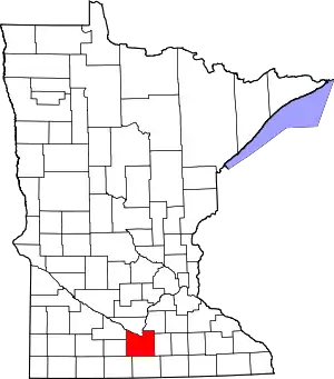 Map of Minnesota highlighting Blue Earth County | |
| Townships | ||
| CDP | ||
| Unincorporated communities | ||
| Footnotes | ‡This populated place also has portions in an adjacent county or counties | |
| ||