Mankato, Minnesota
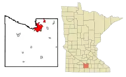
Mankato (/mænˈkeɪtoʊ/ man-KAY-toh) is a city in Blue Earth, Nicollet, and Le Sueur counties in the state of Minnesota. The population was 39,309 according to the 2010 census,[5] making it the fifth largest city in Minnesota outside the Minneapolis–Saint Paul metropolitan area. It is along a large bend of the Minnesota River at its confluence with the Blue Earth River. Mankato is across the Minnesota River from North Mankato. Mankato and North Mankato have a combined population of over 56,500 according to the 2018 census estimates. It completely encompasses the town of Skyline. North of Mankato Regional Airport, a tiny non-contiguous part of the city lies within Le Sueur County. Most of the city is in Blue Earth County.
Mankato, Minnesota | |
|---|---|
City | |
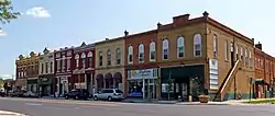 North Riverfront Drive Commercial District | |
| Nickname(s): Key City | |
| Motto(s): Leading the way... | |
 | |
| Coordinates: 44°10′N 94°0′W | |
| Country | United States |
| State | Minnesota |
| Counties | Blue Earth, Nicollet, and Le Sueur |
| Founded | 1852 |
| Government | |
| • Type | City charter |
| • Mayor | Najwa Massad |
| • City manager | Susan Arntz |
| Area | |
| • City | 19.40 sq mi (50.25 km2) |
| • Land | 19.04 sq mi (49.31 km2) |
| • Water | 0.36 sq mi (0.93 km2) |
| Elevation | 794 ft (238 m) |
| Population | |
| • City | 39,309 |
| • Estimate (2019)[3] | 42,931 |
| • Density | 2,254.78/sq mi (870.59/km2) |
| • Metro | 101,647 (US: 353rd) |
| Demonym(s) | Mankatoans |
| Time zone | UTC-6 (CST) |
| • Summer (DST) | UTC-5 (CDT) |
| ZIP codes | 56001-56003 |
| Area code(s) | 507 |
| FIPS code | 27-39878 |
| GNIS feature ID | 0647438[4] |
| Website | mankatomn.gov |
Mankato is the larger of the two principal cities of the Mankato-North Mankato metropolitan area, which covers Blue Earth and Nicollet counties[6] and had a combined population of 94,149 at the 2010 census. The 2018 Census estimate is 101,647. The U.S. Census Bureau designated Mankato a Metropolitan Statistical Area in November 2008.[7]
In 2017, Schools.com named Mankato the second-best small college town in the United States.[8][9]
History
The area was long settled by various cultures of indigenous peoples. After European colonization began on the East Coast, pressure from settlement and other Native American tribes caused various peoples to migrate into the area. By the mid-19th century, four Dakota language–speaking divisions of the Dakota Sioux were the primary indigenous group.
Mankato Township was not settled by European Americans until Parsons King Johnson in February 1852, as part of the 19th-century migration of people from the east across the Midwest. New residents organized the city of Mankato on May 11, 1858. The city was organized by Henry Jackson, Parsons King Johnson, Col. D.A. Robertson, Justus C. Ramsey, and others. A popular story says that the city was supposed to have been named Mahkato, but a typographical error by a clerk established the name as Mankato.[11] According to Warren Upham, quoting historian Thomas Hughes of Mankato, "The honor of christening the new city was accorded to Col. Robertson. He had taken the name from Nicollet's book, in which the French explorer compared the 'Mahkato" or Blue Earth River, with all its tributaries, to the water nymphs and their uncle in the German legend of Undine.'...No more appropriate name could be given the new city, than that of the noble river at whose mouth it is located."[12] While it is uncertain that the city was intended to be called Mahkato, the Dakota called the river Makato Osa Watapa (meaning "the river where blue earth is gathered"). The Anglo settlers adapted that as "Blue Earth River".[12] According to Frederick Webb Hodge, in his Handbook of American Indians North of Mexico, Volume 1, page 801, the town was named after the older of the two like-named chiefs of the Mdewakanton division of the Santee Dakota, whose village stood on or near the site of the present town.
Ishtakhaba, also known as Chief Sleepy Eye, of the Sisseton band of Dakota Indians, was said to have directed settlers to this location. He said the site at the confluence of the Minnesota and Blue Earth Rivers was well suited to building and river traffic, and yet safe from flooding.
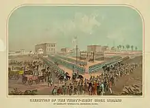
On December 26, 1862, the U.S. Army carried out the largest mass execution in U.S. history at Mankato following the Dakota War of 1862. Thirty-eight Dakota Native Americans were hanged for their parts in the uprising. A military tribunal had sentenced 303 to death, but President Lincoln reviewed the record and pardoned 265, believing they had been involved in legitimate defense against military forces. Episcopal Bishop Henry Benjamin Whipple had urged leniency in the case, but his position was not politically popular in Minnesota, nor was Lincoln's intervention. Two commemorative statues stand on the site of the hangings (now home to the Blue Earth County Library and Reconciliation Park).
In 1880, Mankato ranked fourth in size in the state. The population was 5,500.[13]
Former Vice President Schuyler Colfax died while traveling through Mankato on January 13, 1885.[14]
Cultural references
Mankato was the basis for Deep Valley in Maud Hart Lovelace's Betsy-Tacy series of children's books and novels. The children/young adult wing of the Blue Earth County Library is named in her honor.
In Sinclair Lewis's 1920 novel Main Street, heroine Carol Milford is a former Mankato resident. Lewis describes Mankato as follows: "In its garden-sheltered streets and aisles of elms is white and green New England reborn", alluding to its many migrants from New England, who brought their culture with them. Lewis wrote a substantial portion of the novel while staying at the J.W. Schmidt House at 315 South Broad Street, as now marked by a small plaque in front of the building.[15]
In the Little House on the Prairie television series, Mankato is a trading town that the citizens of Walnut Grove visit. It does not appear in the Laura Ingalls Wilder books.
The 1972 film The New Land, a sequel to The Emigrants (1971), both by Swedish director Jan Troell, depicts the mass execution of 38 Dakota Indians at the end of the 1862 Dakota War.
Geography
According to the United States Census Bureau, the city has a total area of 18.26 square miles (47.29 km2), of which 17.91 square miles (46.39 km2) is land and 0.35 square miles (0.91 km2) is water.[16] The Minnesota, Blue Earth, and Le Sueur Rivers all flow through or near the city.
Climate
Mankato has a humid continental climate, type Dfa (hot summer subtype). Winters are cold, with snow cover (continuous most winter seasons) beginning typically between mid-November and mid-December, ending in March most years. However, Mankato often receives less snow than areas to its north and east. For example, Minneapolis, 75 miles northeast of Mankato, averages over 54 inches or 1.37 metres of snow per winter season, compared to Mankato's seasonal average of 35 inches or 0.89 metres. The coldest month, January, has an average monthly temperature around 14 °F or −10.0 °C. A significant hazard during winter is dangerously low wind-chill temperatures, as Arctic air outbreaks rush into the area from Canada, borne on high winds; this can bring ground blizzard conditions, especially in nearby rural areas.
Summers are warm, with occasional but usually brief hot, humid periods, often interspersed with pushes of cooler air from Canada, often preceded by showers and thunderstorms. The hottest month, July, has an average monthly temperature around 73 °F or 22.8 °C. Precipitation falls year round, but falls mostly as snow from December to February, sometimes March, and as showers and thunderstorms during the warmer season, from May to September. Mankato's average wettest months are from June to August, with frequent thunderstorm activity. Mankato lies on the northern fringe of the central United States’ main tornado belt, with lower risk than in Iowa and Missouri to the south. The highest-risk months for severe thunderstorms and (rarely) tornadoes, are May through July. However, a very unusual early tornado outbreak affected areas within 20 miles of Mankato on March 29, 1998, when an F3 tornado hit St. Peter, 13 miles to Mankato's north. On August 17, 1946, tornadoes struck southwestern areas of Mankato and the town of Wells to the southeast, killing 11 people.[17]
| Climate data for Mankato, Minnesota | |||||||||||||
|---|---|---|---|---|---|---|---|---|---|---|---|---|---|
| Month | Jan | Feb | Mar | Apr | May | Jun | Jul | Aug | Sep | Oct | Nov | Dec | Year |
| Record high °F (°C) | 62 (17) |
64 (18) |
84 (29) |
94 (34) |
106 (41) |
105 (41) |
106 (41) |
107 (42) |
100 (38) |
91 (33) |
82 (28) |
66 (19) |
107 (42) |
| Average high °F (°C) | 23 (−5) |
30 (−1) |
41 (5) |
57 (14) |
71 (22) |
80 (27) |
83 (28) |
81 (27) |
73 (23) |
60 (16) |
41 (5) |
27 (−3) |
56 (13) |
| Average low °F (°C) | 6 (−14) |
11 (−12) |
23 (−5) |
36 (2) |
48 (9) |
57 (14) |
62 (17) |
59 (15) |
50 (10) |
37 (3) |
24 (−4) |
11 (−12) |
35 (2) |
| Record low °F (°C) | −38 (−39) |
−33 (−36) |
−27 (−33) |
−3 (−19) |
22 (−6) |
31 (−1) |
39 (4) |
34 (1) |
20 (−7) |
−1 (−18) |
−18 (−28) |
−32 (−36) |
−38 (−39) |
| Average precipitation inches (mm) | 0.96 (24) |
0.78 (20) |
1.94 (49) |
2.88 (73) |
4.13 (105) |
5.02 (128) |
4.88 (124) |
5.31 (135) |
3.18 (81) |
2.49 (63) |
1.80 (46) |
1.05 (27) |
34.42 (875) |
| Average snowfall inches (cm) | 7.5 (19) |
6.2 (16) |
7.9 (20) |
1.6 (4.1) |
0.1 (0.25) |
0 (0) |
0 (0) |
0 (0) |
0 (0) |
0.1 (0.25) |
4.5 (11) |
7.4 (19) |
35.3 (89.6) |
| Source: National Climatic Data Center[18] | |||||||||||||
Demographics
| Historical population | |||
|---|---|---|---|
| Census | Pop. | %± | |
| 1870 | 3,482 | — | |
| 1880 | 5,550 | 59.4% | |
| 1890 | 8,838 | 59.2% | |
| 1900 | 10,599 | 19.9% | |
| 1910 | 10,365 | −2.2% | |
| 1920 | 12,469 | 20.3% | |
| 1930 | 14,039 | 12.6% | |
| 1940 | 15,654 | 11.5% | |
| 1950 | 18,809 | 20.2% | |
| 1960 | 23,797 | 26.5% | |
| 1970 | 30,895 | 29.8% | |
| 1980 | 28,651 | −7.3% | |
| 1990 | 31,477 | 9.9% | |
| 2000 | 32,427 | 3.0% | |
| 2010 | 39,309 | 21.2% | |
| 2019 (est.) | 42,931 | [3] | 9.2% |
| U.S. Decennial Census[19] 2018 Estimate[20] | |||
2010 census
As of the census[2] of 2010, there were 39,309 people, 14,851 households, and 7,093 families residing in the city. The population density was 2,194.8 inhabitants per square mile (847.4/km2). There were 15,784 housing units at an average density of 881.3 per square mile (340.3/km2). The city's racial makeup was 89.9% White, 4.0% African American, 0.3% Native American, 2.8% Asian, 0.8% from other races, and 2.1% from two or more races. Hispanic or Latino people of any race were 2.9% of the population.
There were 14,851 households, of which 22.5% had children under the age of 18 living with them, 35.0% were married couples living together, 9.0% had a female householder with no husband present, 3.7% had a male householder with no wife present, and 52.2% were non-families. 30.9% of all households were made up of individuals, and 9.4% had someone living alone who was 65 years of age or older. The average household size was 2.35 and the average family size was 2.91.
The median age in the city was 25.4 years. 16.3% of residents were under the age of 18; 32.6% were between the ages of 18 and 24; 23.8% were from 25 to 44; 16.6% were from 45 to 64; and 10.6% were 65 years of age or older. The city's gender makeup was 50.0% male and 50.0% female.
2000 census
As of the census of 2000, there were 32,427 people, 12,367 households, and 6,059 families residing in the city. The population density was 2,132.5 people per square mile (823.2/km2). There were 12,759 housing units at an average density of 839.1 per square mile (323.9/km2). The city's racial makeup was 92.55% White, 1.90% African American, 0.34% Native American, 2.81% Asian, 0.10% Pacific Islander, 0.94% from other races, and 1.36% from two or more races. Hispanic or Latino people of any race were 2.22% of the population.
There were 12,367 households, of which 23.6% had children under the age of 18 living with them, 36.7% were married couples living together, 8.8% had a female householder with no husband present, and 51.0% were non-families. 32.2% of all households were made up of individuals, and 9.9% had someone living alone who was 65 years of age or older. The average household size was 2.31 and the average family size was 2.90.
16.9% of the city's residents were under the age of 18; 32.5% were between age 18 and 24; 23.9% were from 25 to 44; 15.4% were from 45 to 64; and 11.3% were age 65 or older. The median age was 25 years. For every 100 females, there were 96.7 males. For every 100 females age 18 and over, there were 95.5 males.
The city's median household income was $33,956, and the median family income was $47,297. Males had a median income of $30,889 versus $22,081 for females. The city's per capita income in 2010 was $25,772.[21] About 8.5% of families and 19.0% of the population were below the poverty line, including 15.6% of those under age 18 and 11.8% of those age 65 or over. In 2010, the Unemployment Rate was 5.7%.[21]
Politics
Mankato is in Minnesota's 1st congressional district, represented by Jim Hagedorn (R).[22] It is in Minnesota Senate district 19, represented by Nick Frentz (DFL), and Minnesota House district 19B, represented by Jack Considine (DFL). Mankato voted overwhelmingly for Joe Biden in the 2020 presidential election.[23]
Media
The major daily newspaper in the area is the Mankato Free Press.
Television
| Channel | Callsign | Affiliation | Branding | Subchannels | Owner | |
|---|---|---|---|---|---|---|
| (virtual) | Channel | Programming | ||||
| 7.1 | KMNF-LD | NBC | KEYC NBC | 7.2 | CW+ | Gray Television |
| 12.1 | KEYC | CBS | KEYC 12 | 12.2 | FOX | Gray Television |
Radio
FM
| FM radio stations | ||||
|---|---|---|---|---|
| Frequency | Call sign | Name | Format | Owner |
| 89.1 FM | K206DI (KTIS-AM translator) | Faith 900 | Christian talk and teaching | University of Northwestern - St. Paul |
| 89.7 FM | KMSU | The Maverick | College | Minnesota State University, Mankato |
| 90.5 FM | KNGA | MPR News | NPR | Minnesota Public Radio |
| 91.5 FM | KGAC | Classical MPR | Classical | Minnesota Public Radio |
| 93.1 FM | KATO | Minnesota 93 | Country | Linder Radio Group |
| 94.1 FM | KXLP | Classic rock | Linder Radio Group | |
| 94.9 FM | K235BH (KTIS-FM translator) | Life 98.5 | Contemporary Christian | University of Northwestern - St. Paul |
| 95.3 FM | K235BH (KCMP translator) | 89.3 The Current | Adult Album Alternative | Minnesota Public Radio |
| 95.7 FM | KMKO | Rock 95 | Active Rock | Digity, LLC |
| 96.7 FM | KDOG | Hot 96.7 | Top 40 | Linder Radio Group |
| 99.1 FM | KEEZ | Mix 99-1 | Hot Adult Contemporary | Alpha Media |
| 100.5 FM | KXAC | Magic 100.5 KXAC | Oldies | Linder Radio Group |
| 101.7 FM | K269EC (KMKO translator) | Rock 95 | Active Rock | Digity, LLC |
| 102.7 FM | K274AL (KTOE-AM translator) | News/Talk | Linder Radio Group | |
| 103.1 FM | K276EH (KFSP-AM translator) | The Fan | Sport Talk | Linder Radio Group |
| 103.5 FM | KYSM | Country 103.5 KYSM | Country | Digity, LLC |
| 104.5 FM | KJLY | Christian | Mid-Iowa Christian Broadcasting | |
| 105.1 FM | K286AW (KCMP translator) | 89.3 The Current | Adult Album Alternative | Minnesota Public Radio |
| 105.5 FM | KRBI | River 105 | Adult contemporary | Digity, LLC |
| 107.1 FM | K296ER (KJLY translator) | Christian | Mid-Iowa Christian Broadcasting | |
AM radio
| AM radio stations | ||||
|---|---|---|---|---|
| Frequency | Call sign | Name | Format | Owner |
| 860 | KNUJ | News/Talk | James Ingstad | |
| 1230 | KFSP | The Fan | Sports/Sports Talk | Linder Radio Group |
| 1420 | KTOE | News/Talk | Linder Radio Group | |
Economy
Top employers
According to the City's 2018 Comprehensive Annual Financial Report,[24] the top employers in the city are:
| # | Employer | # of employees |
|---|---|---|
| 1 | Mayo Clinic Health System | 2,300 |
| 2 | Minnesota State University | 1,816 |
| 3 | Independent school District 77 | 1,450 |
| 4 | Mankato Clinic | 750 |
| 5 | Hy-Vee | 710 |
| 6 | Blue Earth County | 479 |
| 7 | Mankato Rehabilitation Center Inc | 441 |
| 8 | Monarch Healthcare Management | 436 |
| 9 | The City of Mankato | 382 |
| 10 | Walmart | 350 |
Education
The Mankato Area Public Schools are consolidated to include the cities of Mankato, North Mankato, Eagle Lake, and Madison Lake. There are ten elementary schools (Franklin, Eagle Lake, Kennedy, Washington, Roosevelt, Jefferson, Monroe, Hoover, Rosa Parks, and Bridges); two middle schools (Dakota Meadows Middle School and Prairie Winds Middle School); and two high schools (Mankato West High School and Mankato East High School).
Mankato has four parochial schools: Loyola Catholic School, Immanuel Lutheran Grade School and High School (K–12), Mount Olive Lutheran School (K–8) and Risen Savior Lutheran School (K–8). There is also a public charter school, Kato Public Charter School. The alternative school Central High, on Fulton Street, is another educational option.
The Blue Earth County Library, part of the Traverse des Sioux Library System, serves the city.
Higher education institutions
- Minnesota State University was opened as the second state normal school in 1868 and is the second largest university in the state of Minnesota by enrollment. With an annual operating budget of over $200 million, Minnesota State provides a net economic benefit of over $452 million annually to Minnesota's south-central region.[25] It is one of the largest employers in the Mankato area.[26]
- South Central College
- Bethany Lutheran College
- Rasmussen College
Major events
- Minnesota State University was home to the Minnesota Vikings summer training camp for 52 years.[27] The Vikings announced their training camp would move to Eagan starting in 2018.[28]
Places of interest

- The Betsy & Tacy Houses
- Blue Earth County Courthouse, listed on the National Register of Historic Places (NRHP)
- Federal Courthouse and Post Office (NRHP)
- First National Bank of Mankato (NRHP)
- First Presbyterian Church (NRHP)
- Good Counsel Hill
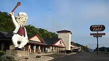
- Happy Chef original restaurant and company headquarters; Mankato also is home to the last surviving 36-foot Happy Chef statue
- The Hubbard House Blue Earth County Historical Society – French Second Empire style built in 1871 (NRHP)
- ISG Field, home of the Mankato Moondogs of the Northwoods League, a collegiate summer baseball league
- The Cray Mansion (NRHP)
- Minneopa State Park is west of Mankato (two NRHP listings)
- Mount Kato, a local winter sports facility
- River Hills Mall
- Sibley Park is a city park along the river in Mankato.
- The Mayo Clinic Health System Event Center, an arena in downtown Mankato formerly operated under the names Mankato Civic Center, Midwest Wireless Civic Center, Alltel Center, Verizon Wireless Center, and Verizon Center[29]
Notable people
- Barry Anderson, former Judge of the Minnesota Court of Appeals and current Associate Justice of the Minnesota Supreme Court
- Walter Jackson Bate, Pulitzer Prize-winning biographer, born in Mankato in 1918
- Daniel Buck, Minnesota jurist and politician
- Con Bunde, Alaska state legislator and educator
- Frederick Russell Burnham, "father of the international scouting movement," born near Mankato on May 11, 1861
- Joseph Francis Busch Roman Catholic Prelate, Diocese of Lead now Diocese of Rapid City, South Dakota, Diocese of Saint Cloud, Minnesota
- Howard Burnham, mining engineer and a spy for the government of France, born near Mankato on May 27, 1870
- Jimmy Chin, professional climber, mountaineer, skier, director and photographer, Academy Award winner for Best Documentary Feature
- George Contant, outlaw of the American West, brother of John Sontag; later lectured against a life of crime
- Marvel Cooke, journalist, writer and civil rights activist
- Craig Dahl, NFL safety, New York Giants
- Adolph Olson Eberhart, seventeenth Governor of Minnesota
- William S. Ervin, Attorney General of Minnesota[30]
- Cliff Fagan, basketball referee, member of the Basketball Hall of Fame
- Sal Frederick, Minnesota legislator and businessman
- Kelly Gage, Minnesota legislator and lawyer
- Albert P. Halfhill, father of the tuna packing industry
- Milton Hanna, Civil War veteran and Medal of Honor recipient
- Justin Hartwig, former NFL center
- Geoff Herbach, novelist
- Robert Louis Hodapp, Roman Catholic bishop
- Ron Johnson, Republican U.S. Senator from Wisconsin
- Jack Kodell, stage magician
- Sinclair Lewis, author
- Mike Lindell, founder and CEO of MyPillow
- Maud Hart Lovelace, author of the Betsy-Tacy series of books
- Bob Paffrath, professional football player
- Mike Ploog, comic book and film-production artist
- Dudley Riggs, Brave New Workshop, graduated from Minnesota State University Mankato
- Joseph Rosser, Secretary of Minnesota Territory and lawyer
- Daniel L. Ryan, Roman Catholic bishop
- Julia Sears, pioneering feminist and suffragette
- John Sontag, outlaw, born in Mankato; crimes in Minnesota and California
- Glen Taylor, businessman and owner of the Minnesota Timberwolves and Minnesota Lynx basketball teams
- John Eaton Tourtellotte, lawyer, Civil War general, and philanthropist
- Adam Thielen, NFL wide receiver, Minnesota Vikings, graduated from Minnesota State University
- Arthur S. Thomas, Chief of Chaplains of the US Air Force
- Alma Wagen, first female guide at Mount Rainier National Park
- Tim Walz, former teacher at Mankato West High School, forty-first Governor of Minnesota, and former US Representative for Minnesota's 1st congressional district
- Cedric Yarbrough, actor who graduated from Minnesota State University
- Steve Zahn, actor and comedian, was raised in Mankato
Rankings and ratings
- Bizjournals.com, 2006
Mankato/North Mankato was ranked 16th in the nation in a survey of 577 cities nationwide. The survey rates the country's "micropolitan" areas in multiple quality of life criteria.
- America's Promise, 2005
This national youth advocacy group, founded by Gen. Colin Powell and dedicated to making children and youth a priority, named Mankato one of the top 100 communities in the nation for kids. Criteria included the presence of caring adults, transportation for children, presence of places to learn and grow, education opportunities, and opportunities for children to volunteer.
- Rolling Stone College Guide, 2005
Rolling Stone magazine named Mankato/St. Peter one of the top 50 college towns in the country because of its rich and diverse music scene.
- Site Selection magazine, 2002, 2003 and 2004
For three consecutive years, Mankato/North Mankato ranked in the top 25 small cities nationwide for new and expanded corporate facility projects. The community ranked 16th in 2002 (the Minnesota community to make the list), 13th in 2003, and 23rd in 2004.
- Bizdemographics awarded Mankato an "A" in terms of business climate, a sign of excellent economic health. The study considered characteristics such as population growth, per capita income, job growth, and local educational levels.
- Demographics Daily, September 2000
Mankato and North Mankato placed in the top 50 U.S. cities classified as "dreamtowns". Cities were ranked according to quality of life indicators such as vitality, supply of good jobs, freedom from stress, connection to cultural mainstream, support for schools, access to health care, low cost of living, and small town character.
- The New Rating Guide to Life in America's Small Cities, January 1998
The City of Mankato was named the 14th most livable micropolitan in America and number one in Minnesota.
- In 2004 Mankato was rated as the funniest city in America by Hallmark Cards.
Transportation
Public transportation in Mankato is provided by the Mankato Transit System. The city is served by Mankato Regional Airport which has no commercial flights. Under MnDOT's 2015 State Rail Plan, Mankato is listed as a Tier 1 Corridor for regional rail service from Minneapolis and/or St. Paul. U.S. Highways 14 and 169 and Minnesota State Highways 22 and 60 are four of the main routes in Mankato.
Major highways
The following routes are within the city of Mankato.
References
- "2019 U.S. Gazetteer Files". United States Census Bureau. Retrieved July 26, 2020.
- "U.S. Census website". United States Census Bureau. Retrieved May 28, 2013.
- "Population and Housing Unit Estimates". United States Census Bureau. May 24, 2020. Retrieved May 27, 2020.
- "U.S. Board on Geographic Names". United States Geological Survey. United States Geological Survey. October 25, 2007. Archived from the original on July 1, 2015. Retrieved November 21, 2019.
- "2010 Census Redistricting Data (Public Law 94-171) Summary File". American FactFinder. United States Census Bureau. Retrieved April 27, 2011.
- "Micropolitan Statistical Areas and Components, December 2006". Census.gov. Office of Management and Budget. May 11, 2007. Archived from the original on June 29, 2007. Retrieved November 21, 2019.
- Linehan, Dan (December 4, 2008). "Mankato designated MSA". Mankato Free Press. Archived from the original on January 28, 2013. Retrieved November 21, 2019.
- LaPonsie, Maryalene (July 24, 2017). "The 25 Best Small College Towns 2017". schools.com. Archived from the original on September 20, 2017. Retrieved March 24, 2020.CS1 maint: unfit URL (link)
- Stavig, Vicky (April 25, 2018). "How Mankato Came to Be Minnesota's Hottest Economic Region". Twin Cities Business Magazine. MSP Communications. Archived from the original on March 24, 2020. Retrieved March 24, 2020.
- "Henry Jackson of St. Paul and Mankato. First Justice of the Peace in St. Paul (1843), first Postmaster of St. Paul (1846-1849), member of the first Territorial Assembly and pioneer settler of Mankato". Minnesota Historical Society. Archived from the original on March 24, 2019. Retrieved November 21, 2019.
- "History of Blue Earth County". Blue Earth County, Minnesota. Blue Earth County, Minnesota. Archived from the original on August 14, 2019. Retrieved November 21, 2019.
- Upham, Warren (2001). Minnesota Place Names, A Geographical Encyclopedia, 3rd Edition. Saint Paul, Minnesota: Minnesota Historical Society. p. 65. ISBN 0-87351-396-7.
- Minnesota Place Names: A Geographical Encyclopedia, Minnesota Historical Society website. http://mnplaces.mnhs.org/upham/index.cfm Archived June 20, 2007, at the Wayback Machine
- Glass, Andrew (January 13, 2010). "Former House Speaker Schuyler Colfax dies, Jan. 13, 1885". Politico. Retrieved December 29, 2020.
- "Historical Attractions". Archived from the original on July 14, 2013. Retrieved June 4, 2013.
- "US Gazetteer files 2010". United States Census Bureau. Archived from the original on February 20, 2011. Retrieved November 13, 2012.
- Nienaber, Dan (May 31, 2006). "Memories of 1946 tornado remain vivid". Mankato Free Press. Archived from the original on December 5, 2019. Retrieved November 21, 2019.
- "Monthly and Season Total SnowFall Amount". NCDC. 2010. Archived from the original on June 29, 2011. Retrieved July 2, 2010.
- United States Census Bureau. "Census of Population and Housing". Retrieved September 12, 2013.
- "Population Estimates". United States Census Bureau. Retrieved June 29, 2019.
- Scott, Daniel (May 20, 2011). City of Mankato, Minnesota Comprehensive Annual Financial Report for the Fiscal Year Ended December 31, 2010 (Report). City of Mankato, Minnesota Finance Department. Retrieved November 21, 2019.
- "Representative Hagedorn Sworn into Office". January 3, 2019. Archived from the original on January 4, 2019. Retrieved January 3, 2019.
- . January 3, 2019 https://www.nytimes.com/interactive/2021/upshot/2020-election-map.html. Archived from the original on February 2, 2021. Retrieved February 2, 2021. Missing or empty
|title=(help) - Scott, Daniel (June 25, 2019). "2018 City of Mankato CAFR". City of Mankato. Retrieved March 22, 2020.
- "The Economic Impact of Minnesota State University, Mankato" (PDF). Amherst H. Wilder Research Foundation. Archived from the original (PDF) on April 26, 2016. Retrieved October 23, 2015.
- Stavig, Vicky (April 25, 2018). "How Mankato Came to Be Minnesota's Hottest Economic Region". Twin Cities Business Magazine. MSP Communications. Archived from the original on August 17, 2018. Retrieved August 16, 2018.
Top Five Employers: Taylor Cos. (2,400 employees), Mayo Clinic Health System (1,830 employees), Minnesota State University Mankato (1,700 employees), Mankato Area Public Schools (1,200 employees), MRCI (1,200 employees), Source: Greater Mankato Growth
- "Mankato readies for Vikings training camp". The Washington Times. Archived from the original on November 21, 2014. Retrieved November 12, 2014.
- Olson, Rochelle (July 19, 2017). "Minnesota Vikings, Mankato part ways after one final training camp beginning next week". Star Tribune. Archived from the original on July 31, 2017. Retrieved August 11, 2017.Vikings-Mankato-Part-Ways
- Linehan, Dan (June 25, 2007). "Civic center to be Alltel Center". Mankato Free Press. Archived from the original on March 21, 2019. Retrieved March 21, 2019.
- The Legislative Manual of the State of Minnesota. Saint Paul, MN: Minnesota Secretary of State. 1937. p. 482 – via Google Books.
External links
| Wikimedia Commons has media related to Mankato, Minnesota. |
| Wikivoyage has a travel guide for Mankato, Minnesota. |
- City of Mankato official website
- Mankato Chamber of Commerce
- Greater Mankato Convention & Visitors Bureau
- Mankato, Minnesota at Curlie
Municipalities and communities of Blue Earth County, Minnesota, United States | ||
|---|---|---|
| Cities |  Map of Minnesota highlighting Blue Earth County | |
| Townships | ||
| CDP | ||
| Unincorporated communities | ||
| Footnotes | ‡This populated place also has portions in an adjacent county or counties | |
| ||
Municipalities and communities of Le Sueur County, Minnesota, United States | ||
|---|---|---|
| Cities | 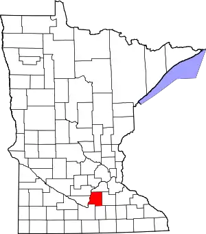 Map of Minnesota highlighting Le Sueur County | |
| Townships | ||
| Unincorporated communities | ||
| Footnotes | ‡This populated place also has portions in an adjacent county or counties | |
| ||
Municipalities and communities of Nicollet County, Minnesota, United States | ||
|---|---|---|
| Cities | 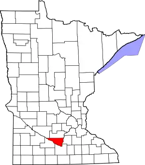 Map of Minnesota highlighting Nicollet County | |
| Townships | ||
| Unincorporated communities | ||
| Ghost town | ||
| Footnotes | ‡This populated place also has portions in an adjacent county or counties | |
| ||
| Core Cities | 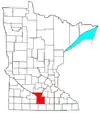 | ||||
|---|---|---|---|---|---|
| Incorporated Places |
| ||||
| Counties | |||||
† indicates a county seat. ‡ indicates that it is partially in the metropolitan area. | |||||

| Authority control |
|---|