Sterling Township, Blue Earth County, Minnesota
Sterling Township is a township in Blue Earth County, Minnesota, United States. The population was 276 as of the 2000 census.[3]
Sterling Township | |
|---|---|
 Sterling Township Location within the state of Minnesota  Sterling Township Sterling Township (the United States) | |
| Coordinates: 43°53′43″N 94°4′9″W | |
| Country | United States |
| State | Minnesota |
| County | Blue Earth |
| Area | |
| • Total | 36.0 sq mi (93.3 km2) |
| • Land | 34.4 sq mi (89.1 km2) |
| • Water | 1.6 sq mi (4.2 km2) |
| Elevation | 1,004 ft (306 m) |
| Population (2000) | |
| • Total | 276 |
| • Density | 8.0/sq mi (3.1/km2) |
| Time zone | UTC-6 (Central (CST)) |
| • Summer (DST) | UTC-5 (CDT) |
| FIPS code | 27-62716[1] |
| GNIS feature ID | 0665707[2] |
Geography
Public Land Survey System (PLSS) of the United States: Township 105 North, Range 27 West, Fifth Meridian, 23,044 Acres. According to the United States Census Bureau, the township has a total area of 36.0 square miles (93.3 km2), of which 34.4 square miles (89.1 km2) is land and 1.6 square miles (4.2 km2) (4.50%) is water.
Unincorporated communities
Major highways
Lakes
- Lura Lake (vast majority)
Adjacent townships
- Lyra Township (north)
- Beauford Township (northeast)
- Mapleton Township (east)
- Delavan Township, Faribault County (south)
- Winnebago City Township, Faribault County (southwest)
- Shelby Township (west)
- Vernon Center Township (northwest)
Cemeteries
The township contains these two cemeteries: Jackson Lake and Sterling.
Demographics
As of the census[1] of 2000, there were 276 people, 111 households, and 86 families residing in the township. The population density was 8.0 people per square mile (3.1/km2). There were 114 housing units at an average density of 3.3/sq mi (1.3/km2). The racial makeup of the township was 98.91% White, and 1.09% from two or more races. Hispanic or Latino of any race were 0.72% of the population.
There were 111 households, out of which 30.6% had children under the age of 18 living with them, 67.6% were married couples living together, 5.4% had a female householder with no husband present, and 22.5% were non-families. 20.7% of all households were made up of individuals, and 14.4% had someone living alone who was 65 years of age or older. The average household size was 2.49 and the average family size was 2.86.
In the township the population was spread out, with 23.6% under the age of 18, 8.0% from 18 to 24, 24.3% from 25 to 44, 25.4% from 45 to 64, and 18.8% who were 65 years of age or older. The median age was 42 years. For every 100 females, there were 102.9 males. For every 100 females age 18 and over, there were 97.2 males.
The median income for a household in the township was $49,091, and the median income for a family was $50,417. Males had a median income of $29,063 versus $24,583 for females. The per capita income for the township was $20,442. About 3.5% of families and 2.6% of the population were below the poverty line, including 2.7% of those under the age of eighteen and none of those 65 or over.
References
- United States National Atlas
- United States Census Bureau 2007 TIGER/Line Shapefiles
- United States Board on Geographic Names (GNIS)
- "U.S. Census website". United States Census Bureau. Retrieved 2008-01-31.
- "US Board on Geographic Names". United States Geological Survey. 2007-10-25. Retrieved 2008-01-31.
- "U.S. Census website". Retrieved 2008-12-30.
- Upham, Warren (1920). Minnesota Geographic Names: Their Origin and Historic Significance. Minnesota Historical Society. p. 63.
Municipalities and communities of Blue Earth County, Minnesota, United States | ||
|---|---|---|
| Cities | 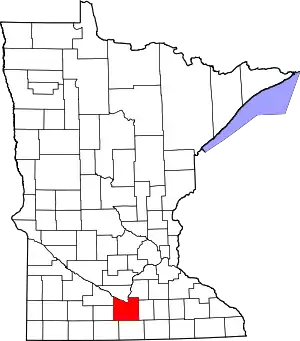 Map of Minnesota highlighting Blue Earth County | |
| Townships | ||
| CDP | ||
| Unincorporated communities | ||
| Footnotes | ‡This populated place also has portions in an adjacent county or counties | |
| ||