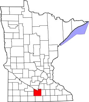
Blue Earth County, Minnesota
Blue Earth County is a county in the State of Minnesota. As of the 2010 United States Census, the population was 64,013.[2] Its county seat is Mankato.[3] The county is named for the Blue Earth River and for the deposits of blue-green clay once evident along the banks of the Blue Earth River.
Blue Earth County | |
|---|---|
 | |
 Location within the U.S. state of Minnesota | |
 Minnesota's location within the U.S. | |
| Coordinates: 44°02′N 94°04′W | |
| Country | |
| State | |
| Founded | March 5, 1853[1] |
| Named for | Blue Earth River |
| Seat | Mankato |
| Largest city | Mankato |
| Area | |
| • Total | 766 sq mi (1,980 km2) |
| • Land | 748 sq mi (1,940 km2) |
| • Water | 18 sq mi (50 km2) 2.3%% |
| Population (2010) | |
| • Total | 64,013 |
| • Estimate (2019) | 67,653 |
| • Density | 89.5/sq mi (34.6/km2) |
| Time zone | UTC−6 (Central) |
| • Summer (DST) | UTC−5 (CDT) |
| Congressional district | 1st |
| Website | www |
Blue Earth County is part of the Mankato-North Mankato metropolitan area.
History
The area of Blue Earth County was once occupied by the Dakota Indians. French explorer Pierre-Charles Le Sueur was an early explorer in this area, arriving where the Minnesota and Blue Earth rivers meet. He made an unsuccessful attempt to mine copper from the blue earth. The area remained under French control until 1803 when it passed to the United States in the Louisiana Purchase.
When Minnesota became a territory in 1849, the territorial government became interested in settling the river valley. In 1850 the first steamboat trip, starting in St. Paul, traveled on the Minnesota River and came to the Blue Earth River. The first white settlers, P. K. Johnson and Henry Jackson, debarked and settled in present-day Mankato. The ratification of the Mendota and Traverse des Sioux treaties in 1851 effectively forced the Dakota to move to nearby reservations.
The county of Blue Earth was created after a division of the Minnesota Territory on March 5, 1853, from portions of Dakota County and free territory. It was named for the Blue Earth River.[4] The first government officials were appointed by Alexander Ramsey, the territorial governor. That October the first election was held, with 22 ballots being taken.
Unfulfilled treaty promises and starvation on the reservation led to the Dakota War of 1862, which resulted in Dakota defeat and the largest mass execution in US history in Mankato. In 1868 the railroads' arrival helped with the growth and development of many areas, including Blue Earth. The railroads allowed immigrants and Yankee settlers into the area.
Geography
The Minnesota River flows southeasterly along the western part of the county's north boundary line. It is joined by the Blue Earth River which flows northerly through the western central part of the county. The Watonwan River flows northwesterly through the NE part of the county, discharging into the Blue Earth. The Little Cobb River flows northwesterly through the SE part of the county, meeting with the Cobb River which flows northerly through the lower part of the county into the Blue Earth River. The Le Sueur River also flows west-northwesterly through the SE part of the county, discharging into the Blue Earth River.
The county terrain consists of low rolling hills, with the area (except around built-up zones, and in areas carved by runoff) devoted to agriculture.[6] It slopes generally to the north. Its southwest corner is 1,086' (331m) above sea level.[7][8]
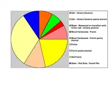
The county has an area of 766 square miles (1,980 km2), of which 748 square miles (1,940 km2) is land and 18 square miles (47 km2) (2.3%) is water.[9] The Blue Earth River and Le Sueur River flow through a part of the county. The land surface is relatively flat with over 30 lakes in the county. There are many "closed forest savannas" that some call the big woods in the county's northeast. The rivers that flow out of the northeast are surrounded by these big woods. Most of the county is grassland prairie but scattered parts are wet prairie. Some spots that surround the rivers are oak openings and barren brushland.
Major highways
Lakes[6]
- Crystal Lake
- Albert Lake
- Alice Lake
- Armstrong Lake
- Ballantyne Lake
- Born Lake
- Cottonwood Lake
- Duck Lake
- Eagle Lake
- George Lake
- Gilfillin Lake
- Ida Lake
- Indian Lake
- Knights Lake
- Lake Crystal
- Lieberg Lake
- Lily Lake
- Long Lake
- Loon Lake
- Lura Lake (part)
- Madison Lake
- Mennenga Lake
- Mills Lake
- Minnesota Lake (part)
- Mud Lake
- Perch Lake
- Porter Lake
- Rice Lake
- Severson Lake
- Strom Lake
- Wita Lake
Adjacent counties
- Nicollet County - north
- Le Sueur County - northeast
- Waseca County - east
- Faribault County - south
- Martin County - southwest
- Watonwan County - west
- Brown County - northwest
Climate and weather
| Mankato, Minnesota | ||||||||||||||||||||||||||||||||||||||||||||||||||||||||||||
|---|---|---|---|---|---|---|---|---|---|---|---|---|---|---|---|---|---|---|---|---|---|---|---|---|---|---|---|---|---|---|---|---|---|---|---|---|---|---|---|---|---|---|---|---|---|---|---|---|---|---|---|---|---|---|---|---|---|---|---|---|
| Climate chart (explanation) | ||||||||||||||||||||||||||||||||||||||||||||||||||||||||||||
| ||||||||||||||||||||||||||||||||||||||||||||||||||||||||||||
| ||||||||||||||||||||||||||||||||||||||||||||||||||||||||||||
In recent years, average temperatures in the county seat of Mankato have ranged from a low of 5 °F (−15 °C) in January to a high of 83 °F (28 °C) in July, although a record low of −35 °F (−37 °C) was recorded in February 1996 and a record high of 107 °F (42 °C) was recorded in August 1988. Average monthly precipitation ranged from 0.78 inches (20 mm) in February to 5.09 inches (129 mm) in June.[10]
Demographics
| Historical population | |||
|---|---|---|---|
| Census | Pop. | %± | |
| 1860 | 4,803 | — | |
| 1870 | 17,302 | 260.2% | |
| 1880 | 22,889 | 32.3% | |
| 1890 | 29,210 | 27.6% | |
| 1900 | 32,263 | 10.5% | |
| 1910 | 29,337 | −9.1% | |
| 1920 | 31,477 | 7.3% | |
| 1930 | 33,847 | 7.5% | |
| 1940 | 36,203 | 7.0% | |
| 1950 | 38,327 | 5.9% | |
| 1960 | 44,385 | 15.8% | |
| 1970 | 52,322 | 17.9% | |
| 1980 | 52,314 | 0.0% | |
| 1990 | 54,044 | 3.3% | |
| 2000 | 55,941 | 3.5% | |
| 2010 | 64,013 | 14.4% | |
| 2019 (est.) | 67,653 | [11] | 5.7% |
| US Decennial Census[12] 1790-1960[13] 1900-1990[14] 1990-2000[15] 2010-2019[2] | |||
2000 census
As of the 2000 United States Census, the county had 55,941 people, 21,062 households, and 12,616 families. The population density was 74.8/sq mi (28.9/km2). There were 21,971 housing units at an average density of 29.4/sqmi (11.3/km2). The county's racial makeup was 94.96% White, 1.19% Black or African American, 0.28% Native American, 1.79% Asian, 0.06% Pacific Islander, 0.69% from other races, and 1.03% from two or more races. 1.77% of the population were Hispanic or Latino of any race. 47.6% were of German, 13.6% Norwegian and 6.5% Irish ancestry.
There were 21,062 households, of which 29.10% had children under the age of 18 living with them, 48.60% were married couples living together, 7.80% had a female householder with no husband present, and 40.10% were non-families. 27.10% of all households were made up of individuals, and 9.50% had someone living alone who was 65 years of age or older. The average household size was 2.46 and the average family size was 2.99.
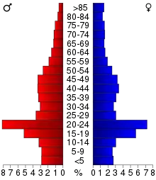
21.40% of the county's population was under the age of 18, 22.10% were from age 18 to 24, 25.60% were from age 25 to 44, 18.80% were from age 45 to 64, and 12.10% were age 65 or older. The median age was 30 years. For every 100 females, there were 99.10 males. For every 100 females age 18 and over, there were 97.40 males.
The county's median household income was $38,940, and the median family income was $50,257. Males had a median income of $32,087 versus $22,527 for females. The county's per capita income was $18,712. About 6.10% of families and 12.90% of the population were below the poverty line, including 10.50% of those under age 18 and 9.40% of those age 65 or over.
Communities
Cities
Census-designated place
Unincorporated communities
Townships
- Beauford Township
- Butternut Valley Township
- Cambria Township
- Ceresco Township
- Danville Township
- Decoria Township
- Garden City Township
- Jamestown Township
- Judson Township
- Le Ray Township
- Lime Township
- Lincoln Township
- Lyra Township
- Mankato Township
- Mapleton Township
- McPherson Township
- Medo Township
- Pleasant Mound Township
- Rapidan Township
- Shelby Township
- South Bend Township
- Sterling Township
- Vernon Center Township
Government and politics
As of 2020, Blue Earth County has voted for the winning presidential candidate in 13 of the last 15 elections, the exceptions being 1988 and 2004. Since 1988 it has tilted toward the Democratic Party, but in 2000 and 2016 it voted for the Republican candidates. Despite voting for Trump in 2016, the county voted for Joe Biden in 2020.
| Year | Republican | Democratic | Third parties |
|---|---|---|---|
| 2020 | 46.4% 16,731 | 50.8% 18,330 | 2.7% 990 |
| 2016 | 46.6% 15,667 | 43.0% 14,428 | 10.4% 3,498 |
| 2012 | 43.5% 14,916 | 53.0% 18,164 | 3.5% 1,194 |
| 2008 | 42.2% 14,782 | 55.1% 19,325 | 2.8% 963 |
| 2004 | 47.5% 15,737 | 50.9% 16,865 | 1.6% 517 |
| 2000 | 47.2% 12,942 | 45.0% 12,329 | 7.8% 2,131 |
| 1996 | 36.0% 9,082 | 49.2% 12,420 | 14.9% 3,759 |
| 1992 | 31.7% 8,813 | 41.4% 11,531 | 26.9% 7,503 |
| 1988 | 48.7% 11,959 | 50.4% 12,375 | 0.9% 218 |
| 1984 | 54.3% 14,298 | 45.1% 11,877 | 0.7% 172 |
| 1980 | 45.8% 11,966 | 41.8% 10,930 | 12.4% 3,242 |
| 1976 | 46.7% 11,998 | 50.3% 12,930 | 3.0% 760 |
| 1972 | 53.7% 12,702 | 45.0% 10,638 | 1.4% 322 |
| 1968 | 49.0% 9,571 | 47.4% 9,254 | 3.6% 712 |
| 1964 | 42.6% 8,009 | 56.9% 10,687 | 0.5% 101 |
| 1960 | 58.4% 11,328 | 41.5% 8,052 | 0.2% 33 |
| 1956 | 67.5% 11,398 | 32.4% 5,467 | 0.1% 21 |
| 1952 | 70.3% 11,867 | 29.4% 4,952 | 0.3% 51 |
| 1948 | 50.3% 7,520 | 48.6% 7,272 | 1.1% 162 |
| 1944 | 64.7% 9,429 | 35.0% 5,098 | 0.4% 54 |
| 1940 | 61.9% 9,642 | 37.7% 5,880 | 0.4% 62 |
| 1936 | 37.6% 5,550 | 55.9% 8,255 | 6.5% 964 |
| 1932 | 40.5% 5,550 | 57.9% 7,925 | 1.6% 216 |
| 1928 | 60.7% 8,120 | 38.7% 5,177 | 0.6% 79 |
| 1924 | 55.1% 6,773 | 9.1% 1,123 | 35.8% 4,399 |
| 1920 | 79.1% 8,894 | 17.6% 1,974 | 3.4% 383 |
| 1916 | 54.0% 2,864 | 41.7% 2,211 | 4.4% 233 |
| 1912 | 25.4% 1,344 | 38.3% 2,025 | 36.3% 1,922 |
| 1908 | 56.2% 3,297 | 37.3% 2,191 | 6.5% 379 |
| 1904 | 67.4% 3,573 | 26.8% 1,419 | 5.8% 308 |
| 1900 | 58.7% 3,647 | 36.3% 2,254 | 5.1% 314 |
| 1896 | 57.5% 4,055 | 38.9% 2,744 | 3.6% 253 |
| 1892 | 46.0% 2,680 | 41.2% 2,399 | 12.8% 747 |
| Position | Name | District | Next Election | |
|---|---|---|---|---|
| Commissioner | Colleen Landkamer | District 1 | 2022 | |
| Commissioner and Chairperson | Vance Stuehrenberg | District 2 | 2022 | |
| Commissioner | Mark Piepho | District 3 | 2020 | |
| Commissioner | Will Purvis | District 4 | 2020 | |
| Commissioner | Kip Bruender | District 5 | 2020 | |
| Position | Name | Affiliation | District | |
|---|---|---|---|---|
| Senate | Nick Frentz[18] | Democrat | District 19 | |
| Senate | Julie Rosen[19] | Republican | District 23 | |
| House of Representatives | Jeff Brand[20] | Democrat | District 19A | |
| House of Representatives | Jack Considine[21] | Democrat | District 19B | |
| House of Representatives | Jeremy Munson[22] | Republican | District 23B | |
| Position | Name | Affiliation | District | |
|---|---|---|---|---|
| House of Representatives | Jim Hagedorn[23] | Republican | 1st | |
| Senate | Amy Klobuchar[24] | Democrat | N/A | |
| Senate | Tina Smith[25] | Democrat | N/A | |
References
- "Minnesota Place Names". Minnesota Historical Society. Archived from the original on June 20, 2012. Retrieved March 17, 2014.
- "State & County QuickFacts". United States Census Bureau. Archived from the original on July 7, 2011. Retrieved August 31, 2013.
- "Find a County". National Association of Counties. Archived from the original on May 31, 2011. Retrieved June 7, 2011.
- Upham, Warren (1920). Minnesota Geographic Names: Their Origin and Historic Significance. Minnesota Historical Society. p. 57.
- Nelson, Steven (2011). Savanna Soils of Minnesota. Minnesota: Self. pp. 65-67. ISBN 978-0-615-50320-2.
- Blue Earth County MN Google Maps (accessed 5 March 2019)
- ""Find an Altitude/Blue Earth County MN" Google Maps (accessed 5 March 2019)". Archived from the original on May 21, 2019. Retrieved March 5, 2019.
- Blue Earth County High Point, Minnesota. PeakBagger.com (accessed 5 May 2019)
- "2010 Census Gazetteer Files". US Census Bureau. August 22, 2012. Archived from the original on October 6, 2014. Retrieved October 5, 2014.
- "Monthly Averages for Mankato MN". The Weather Channel. Retrieved November 6, 2011.
- "Population and Housing Unit Estimates". Retrieved March 26, 2020.
- "US Decennial Census". US Census Bureau. Archived from the original on April 26, 2015. Retrieved October 5, 2014.
- "Historical Census Browser". University of Virginia Library. Retrieved October 5, 2014.
- "Population of Counties by Decennial Census: 1900 to 1990". US Census Bureau. Retrieved October 5, 2014.
- "Census 2000 PHC-T-4. Ranking Tables for Counties: 1990 and 2000" (PDF). US Census Bureau. Retrieved October 5, 2014.
- Leip, David. "Atlas of US Presidential Elections". uselectionatlas.org. Retrieved April 17, 2018.
- "Board of Commissioners | Blue Earth County, MN - Official Website". www.co.blue-earth.mn.us. Retrieved June 25, 2020.
- "MN State Senate". www.senate.mn. Retrieved June 25, 2020.
- "MN State Senate". www.senate.mn. Retrieved June 25, 2020.
- "Rep. Jeff Brand (19A) - Minnesota House of Representatives". www.house.leg.state.mn.us. Retrieved June 25, 2020.
- "Rep. Jack Considine Jr. (19B) - Minnesota House of Representatives". www.house.leg.state.mn.us. Retrieved June 25, 2020.
- "Rep. Jeremy Munson (23B) - Minnesota House of Representatives". www.house.leg.state.mn.us. Retrieved June 25, 2020.
- "Representative Jim Hagedorn". Representative Jim Hagedorn. Retrieved June 25, 2020.
- "U.S. Senator Amy Klobuchar". www.klobuchar.senate.gov. Retrieved June 24, 2020.
- "Home". Senator Tina Smith. Retrieved June 24, 2020.
External links
Places adjacent to Blue Earth County, Minnesota | ||||||||||
|---|---|---|---|---|---|---|---|---|---|---|
| ||||||||||
Municipalities and communities of Blue Earth County, Minnesota, United States | ||
|---|---|---|
| Cities | Map of Minnesota highlighting Blue Earth County | |
| Townships | ||
| CDP | ||
| Unincorporated communities | ||
| Footnotes | ‡This populated place also has portions in an adjacent county or counties | |
| ||
| Core Cities | 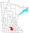 | ||||
|---|---|---|---|---|---|
| Incorporated Places |
| ||||
| Counties | |||||
† indicates a county seat. ‡ indicates that it is partially in the metropolitan area. | |||||

| Authority control |
|---|