Campbell Park
Campbell Park is a district in east-central Milton Keynes, England. It includes the central park for Milton Keynes and is a ward of Central Milton Keynes Parish Council.[2]
| Campbell Park | |
|---|---|
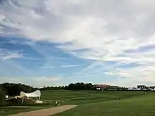 Campbell Park, September 2012. | |
| Location | Milton Keynes, Buckinghamshire, England |
| Coordinates | 52.04722°N 0.74363°W |
| OS grid reference | SP 862 395 |
| Area | 46 hectares (114 acres)[1] |
| Built | 1984 (opened) |
| Architect | Derek Walker, Stuart Mosscrop and Andrew Mahaddie (1973–1975), revised Neil Higson (1980).[1] |
| Owner | Milton Keynes Parks Trust |
| Website | The Parks Trust: Cambpbell Park |
| Official name | Campbell Park, Milton Keynes |
| Designated | 18 August 2020[1] |
| Reference no. | 1467405 |
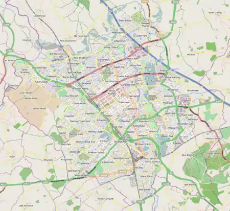 Location of Campbell Park in Milton Keynes | |
Despite the loss of its eponymous district to another parish, the name Campbell Park continues to be used for a neighbouring civil parish in south-central Milton Keynes, that consists of other districts.[3] At the 2011 census, the population of the civil parish was 16,402[4]
The park is listed (grade 2) "due to its historic interest and innovative architectural design".[5]
The Park
Campbell Park, the city park, links central MK to a vast swathe of parkland down to the Ouse Valley, in all the largest and most imaginative park to have been laid out in Britain in the C20.
The magnificently generous city park [is] on the right scale for the city. It lies on axis with the shopping centre and rises to a mound, intentionally reminiscent of a prehistoric site, before spreading out with an exhilarating panorama over Newlands, Willen Lake and its surrounding parkland, with which it makes a single tract of countryside.
The park, part of Central Milton Keynes civil parish, takes up the larger part of the district. It was named in honour of the first chairman of Milton Keynes Development Corporation, Jock Campbell, Baron Campbell of Eskan. The park is listed (grade 2) by Historic England,[1] It is accessed from the main retail/service/entertainment district by a footbridge over the Marlborough Street (B4146, V8) cutting, at the end of Midsummer Boulevard. From here, the park slopes downwards to the Grand Union Canal. A junction between the Grand Union and a new Bedford & Milton Keynes Waterway is proposed for this area.[7]
Civil parish
| Campbell Park CP | |
|---|---|
| Population | 16,402 (2011 Census)[4] |
| OS grid reference | SP865385 |
| Civil parish |
|
| Unitary authority | |
| Ceremonial county | |
| Region | |
| Country | England |
| Sovereign state | United Kingdom |
| Post town | MILTON KEYNES |
| Postcode district | MK6 |
| Dialling code | 01908 |
| Police | Thames Valley |
| Fire | Buckinghamshire |
| Ambulance | South Central |
| UK Parliament | |
| Website | www |
Campbell Park is a civil parish in the borough of Milton Keynes. The parish is bounded by Childs Way (H6) to the north, the River Ouzel to the east, the A5 to the west, and Chaffron Way to the south. The parish includes the Fishermead, Oldbrook, Springfield, Winterhill, and The Woolstones grid-squares. The parish was originally known as Woolstone-cum-Willen,[8] and was formed on 1 April 1934 as a merger of Great Woolstone, Little Woolstone and Willen.[9] The parish was part of Newport Pagnell Rural District until it became part of the borough of Milton Keynes in 1974.[9] The parish was redefined in 2012, when the districts of Campbell Park (sic), Newlands and Willen were reallocated to other parishes. Despite the loss of its eponymous district, the Parish Council continues to use its name.
Fishermead
Fishermead is named after a field called Fishers Mead. The fishing theme is continued in the street naming. All of the streets are named after Cornish fishing villages. There are two schools in the area, The Willows (formerly Newlyn Place) first school and Jubilee Wood School (formed by the amalgamation of Penwith first school and Meadfurlong middle school in 2012). Fishermead is known for its many trees and parks, with several local shops including a Co-op and three fast-food vans.
The townscape in Fishermead is characterised by rectangular blocks of 100-150 metres in length, backing onto shared "garden squares".[10]
The BT telephone exchange known as 'Bradwell Abbey' that serves Central Milton Keynes and the surrounding districts is located here, at the bottom of Helford Place – about three miles east of the real Bradwell Abbey.
Oldbrook
Oldbrook is separated from Central Milton Keynes by Child's Way (H6). Despite its proximity to the central business district of Milton Keynes, it has its own local centre comprising various shops and restaurants including Lidl, Domino's Pizza, Tesco Express, and Pizza Hut. Oldbrook is also home to Milton Keynes Christian Centre which is one of the larger churches in Milton Keynes. There is one school in Oldbrook, Oldbrook First School, situated next door to The Cricketers pub on Oldbrook Blvd.
All of the streets are named following a cricketing theme, most after English cricketers.
Springfield
Springfield is a residential area situated close to Central Milton Keynes. It sits between the districts of Fishermead, Peartree Bridge and the Woolstones. There are two schools in the area, Orchard and Shepherdswell Academy (Formerly Orchard School and Shepherdswell First School).
Both schools are now run by EMLC Academy Trust. The principals of the two schools are Mr Jonathan Cursley (Shepherdswell) and Mr Callum Brown (Orchard). Orchard Academy received its best Ofsted ever in June 2014 when the school was judged to be Good with many outstanding features. Orchard is an ever growing school, becoming a three form entry school in September 2015. The council granted permission in July 2017 for the school to expand, creating an additional 8 classrooms and a new small hall.
Springfield's local pub was recently closed; but it boasts a newly refurbished community centre and a One Stop convenience store. The Grand Union Canal runs by Springfield into nearby Peartree Bridge.
The Woolstones
Winterhill
Winterhill is the most westerly district of the parish, butting up as it does to the West Coast Main Line, south of and convenient to Milton Keynes Central railway station. It is a small district, split from the rest (Knowlhill) of its natural grid square by the railway line and the A5. It consists primarily of 'big shed' retail outlets and campus style offices.
References
- Historic England. "Campbell Park, Milton Keynes (1467405)". National Heritage List for England. Retrieved 23 August 2020.
- http://www.milton-keynes.gov.uk/elections/documents/PUBLIC%5FNOTICE%2Edoc%5B%5D Notice of Outcome of Community Governance Review] – Borough of Milton Keynes
- Parishes in Milton Keynes Archived 8 June 2009 at the Wayback Machine – Milton Keynes Council.
- UK Census (2011). "Local Area Report – Campbell Park (E04012181)". Nomis. Office for National Statistics. Retrieved 17 November 2019.
- Holly Patel (21 August 2020). "Campbell Park in Milton Keynes recognised as one of the finest post-war parks". Milton Keynes Citizen. Retrieved 23 August 2020.
- Nikolaus Pevsner; Elizabeth Williamson; Geoffrey K. Brandwood (2000). Buckinghamshire. The Buildings of England. London: Penguin. p. 487.
- "Route chosen for £150m link canal". BBC News. 28 February 2003.
- "The Story of Campbell Park Parish Council". Archived from the original on 15 April 2010.
- Great Britain Historical GIS / University of Portsmouth, Woolstone Cum Willen. Retrieved 16 April 2010.
- Adrian Jones, Chris Matthews (1 September 2019). "Milton Keynes @ 50". jonestheplanner.co.uk. Retrieved 16 October 2019.CS1 maint: uses authors parameter (link)
