Newport Pagnell
Newport Pagnell is a town and civil parish in the Borough of Milton Keynes, Buckinghamshire, England.[2] The Office for National Statistics records Newport Pagnell as part of the Milton Keynes urban area.[3] It is separated from the rest of the urban area by the M1 motorway, on which Newport Pagnell Services (the second service station to be opened in the UK) is located.
| Newport Pagnell | |
|---|---|
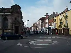 High Street | |
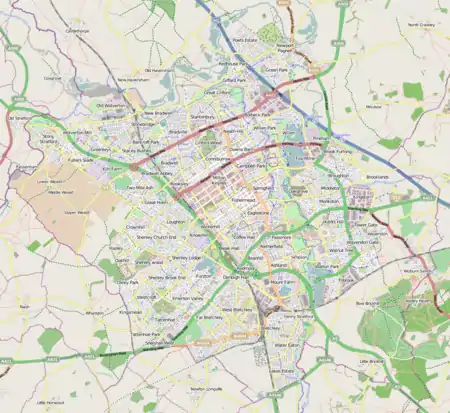 Newport Pagnell 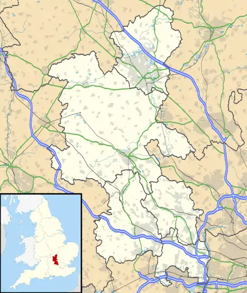 Newport Pagnell Location within Buckinghamshire | |
| Population | 15,118 (2011 Census)[1] |
| OS grid reference | SP873437 |
| Civil parish |
|
| Unitary authority | |
| Ceremonial county | |
| Region | |
| Country | England |
| Sovereign state | United Kingdom |
| Post town | NEWPORT PAGNELL |
| Postcode district | MK16 |
| Dialling code | 01908 |
| Police | Thames Valley |
| Fire | Buckinghamshire |
| Ambulance | South Central |
| UK Parliament | |
History
The town was first mentioned in the Domesday Book of 1086 as Neuport, Old English for 'New Market Town', but by that time, the old Anglo-Saxon town was dominated by the Norman invaders. The suffix 'Pagnell' came later when the manor passed into the hands of the Pagnell (Paynel) family.[4] It was the principal town of the "Three Hundreds of Newport",[5] a district that had almost the same boundary as the modern Borough.
At one time, Newport Pagnell was one of the largest towns in the County of Buckinghamshire (the assizes of the County were occasionally held there). Today, despite its own substantial expansion, it has been completely dwarfed by the growth of Milton Keynes. There were also at one time two hospitals in Newport Pagnell, and six fairs were held for the townsfolk throughout the year.
The 1841 census gave the population as 3,569.[6]
Newport Pagnell became the headquarters of Newport Pagnell Rural District under the Local Government Act 1894. In 1897, Newport Pagnell became the sole civil parish comprising the newly created Newport Pagnell Urban District.
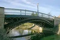
The Grade I listed Tickford Bridge, over the River Ouzel (or Lovat), was built in 1810.[7] It is one of just a few cast iron bridges in Britain that still carry modern road traffic.[7] Near the footbridge at the side, there is a plaque placed by Newport Pagnell Historical Society that gives details of its history and construction. The Ouzel joins the Great Ouse nearby, and a large set of sluice gates, used to control downstream flooding, is located near the bridge.
Between 1817 and 1864, the town was linked to the Grand Junction Canal at Great Linford via the Newport Pagnell Canal.[8] In 1862, the canal owners sold the route to the London and North Western Railway.[9] For a hundred years (1867 to 1967), Newport Pagnell was served by Newport Pagnell railway station, the terminus on the Wolverton to Newport Pagnell branch line.
From 1954 until 2007, the town was the home to the exclusive sports car manufacturer Aston Martin.[10] The Newport Pagnell factory was considered outdated and a new production facility was built near Gaydon in Warwickshire. There is still a service facility in Newport Pagnell, but the factory on the north side of Tickford St has since been demolished apart from the engine shop, board room and offices that are listed buildings. The land behind these has been purchased by Tesco and the supermarket giant had planned to build an outlet on the site, preserving the original remaining buildings for use by the townspeople: as of May 2019, this plan remains on the drawing board. In 2012, Aston Martin completely modernised the service facility and the site also houses a bespoke sales department.
Notable industries in the town include the only remaining vellum manufacturer in the United Kingdom, William Cowley, located at Parchment Works, 97 Caldecote Street.[11]
Over the past 50 years, Newport Pagnell has attracted an increasing amount of investment and of economic growth, due to its fortunes being intertwined with the growth of Milton Keynes. This has led a number of new housing developments in the area.[12]
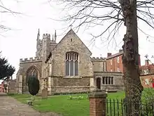
The modern civil parish of Newport Pagnell stops at the M1, but the ecclesiastical parish extends to include Broughton and Caldecote. The parish church is dedicated to St Peter and St Paul.
Education
The town is home to three primary schools - Tickford Park Primary School, Green Park Primary School, and Portfields Primary School - and four pre-schools - River Meadows, Lovat Hall, Cedars and Northern Pastures. It is also home to one of two campuses of Ousedale School (the other one being in nearby Olney), which serves students from across the town and its surrounding villages, and is one of the best performing secondary schools in the Borough of Milton Keynes.[13]
Location and transport
The town is located at the north-eastern corner of the Milton Keynes urban area, and straddles the urban and rural parts of the Borough. It is served by the M1 motorway from Junction 14 (2 miles (3.2 km) to the south) via the A509 which, along with the A422 and Wolverton Road, connects it with Milton Keynes proper. To the east of the town, the A422 and A509 multiplex northwards to form the Newport Pagnell Eastern Bypass, providing links to Bedford, Wellingborough and Kettering.
It was proposed in January 2021 that, with the money that had been given to Milton Keynes Council as part of the UK Government's Active Travel Fund, Tongwell Lane in Newport Pagnell would be converted into a redway, which would better link the town with the Milton Keynes designated area.[14]
Demography
Although Newport Pagnell was excluded from the 1967 designated area of Milton Keynes,[15] its growth has been at a similar level to that of the constituent towns of the latter; the two now join at the M1 and there are no other practical distinctions between them. The Office for National Statistics records Newport Pagnell as part of the Milton Keynes Urban Area.[3] Its population in 1971 was 6,000:[16] by 2001 it had reached 15,020, In 2006, the Borough Council projected that the population will remain broadly stable at this level.[17] However, in its comments on the expansion plans for Milton Keynes, Buckinghamshire County Council challenged this assumption, calling for any further expansion to be to the east of the M1 rather than south across the border into Aylesbury Vale. At the 2011 census, the population had reached 15,118.[1]
Sport and leisure
Newport Pagnell has a Non-League football team Newport Pagnell Town F.C., nicknamed the Swans, who play at The Pavilion on Willen Road. An ITF Taekwon-Do club, Kicks Taekwon-Do Academy, trains at Cedars Primary School, Bury Street, and the swimming pool.
Newport Pagnell Lawn Bowls
Bowls has been played in Newport Pagnell for over 400 years as maps of the Town dating from the mid 17 Century show a public House called “The Bowling Green”. The Newport Pagnell Bowling Club was founded in 1905 and the club used the Bowling Green behind the George pub in Tickford Street (currently The Magic Wok 2019). The game was developing locally due to the Railways, with clubs at Wolverton existing already and Olney forming in 1906. After the Great War, the Club purchased a plot of land known as “The Bully” and the Club remains at this site in Castle Meadow to the current day.
Notable people
- Francis Annesley, 1st Viscount Valentia, was born in Newport Pagnell.
- Nigel Benson, the author, was born in Newport Pagnell.
- Steve Brooker, footballer, was born in Newport Pagnell.
- Henry Bull (1843–1905), cricketer, was born at Newport Pagnell.
- William Bull (1738–1814) (born Irthlingborough) was minister to the Independent Church, now United Reformed Church.
- Letitia Dean went to Cedars School in the town.
- Kelly George, actor and star of BBC children's television series Grange Hill, lived and was educated in the town.
- Richard Hopkins, the television producer, was born in Newport Pagnell.
- Lawrence Humphrey, (or Laurence Humfrey) DD (1527? – 1 February 1590) English theologian, President of Magdalen College, Oxford, and Dean successively of Gloucester and Winchester.
- Richard Meredith, author, lives in Newport Pagnell.
- Gordon Moakes, bassist of Indie band Bloc Party, was educated in Newport Pagnell.
- James Nash, World Touring Car Championship driver, lives in Newport Pagnell.
- Niko B (born 2000), YouTuber and rapper, lives in Newport Pagnell.
- David Oldfield who played for Leicester City, Stoke City and Oxford United, lived in Newport Pagnell.
- Charles Sanford Terry, the historian, musicologist and authority on J. S. Bach, was born in Newport Pagnell in 1864.
- George Walters, born 15 September 1829 in Newport Pagnell, won the Victoria Cross at the Battle of Inkermann (where he was a Sergeant with the 49th Regiment of Foot) on 5 November 1854, by saving the life of Brigadier-General Adams.
- Leah Williamson, professional footballer, played for Arsenal W.F.C. and England.
References
- UK Census (2011). "Local Area Report – Newport Pagnell CP (E04001265)". Nomis. Office for National Statistics. Retrieved 1 October 2019.
- Parishes in Milton Keynes Archived 8 June 2009 at the Wayback Machine – Milton Keynes Council.
- UK Census (2011). "Local Area Report – Milton Keynes built-up area (E34005056)". Nomis. Office for National Statistics. Retrieved 3 August 2020.
- "Parishes : Newport Pagnell". Victoria County History – Buckinghamshire: A History of the County of Buckingham: Volume 4. Victoria History of the Counties of England. 1927. p. 409–422.
- "Newport Hundred: Introduction". Victoria County History – Buckinghamshire: A History of the County of Buckingham: Volume 4. Victoria History of the Counties of England. 1927. p. 268–269.
- The National Cyclopaedia of Useful Knowledge, Vol.III, London, 1847, Charles Knight, p.898
- Historic England. "Tickford Bridge (Grade I) (1125464)". National Heritage List for England. Retrieved 8 January 2015.
- Hadfield, Charles (1970). The Canals of the East Midlands (including part of London) (Second ed.). David & Charles (Publishers) Limited. pp. 272–273. ISBN 071534871X.
- Hadfield (1970) pp. 228–229
- "From Newport Pagnell to Gaydon". The Automobile. November 2007. Cite journal requires
|journal=(help) - "Vellum tradition likely to continue". Print Week. 16 February 2016. Retrieved 8 May 2019.
- "Strategy for 2050 - Engagement Page". MK Futures 2050.
- "For the second year running, Ousedale are the Top School in Milton Keynes at GCSE". MK Pulse.
- "Newport Pagnell to be 'better linked' with Milton Keynes". Milton Keynes Citizen.
- ""North Buckinghamshire (Milton Keynes) New Town (Designation) Order", London Gazette, 24 January 1967, page 827". London Gazette. Retrieved 14 January 2014..
- Census for Newport Pagnell UD
- "Borough of Milton Keynes population bulletin 2005/6, page 21". Archived from the original on 11 September 2006. Retrieved 4 September 2006.
External links
| Wikimedia Commons has media related to Newport Pagnell. |
- The unofficial Newport Pagnell Town website with historical pictures, pictures of the town carnival and a message board for locals and ex pats to keep in touch.
- Newport Pagnell Town Council
- . Encyclopædia Britannica (11th ed.). 1911.
| Unitary authorities | |
|---|---|
| Major settlements | |
| Rivers | |
| Topics |
|
| Authority control |
|---|