Canyon Country, Santa Clarita, California
Canyon Country is a neighborhood in the eastern part of the city of Santa Clarita, in northwestern Los Angeles County, California, United States. It lies along the Santa Clara River between the Sierra Pelona Mountains and the San Gabriel Mountains.
Canyon Country | |
|---|---|
Neighborhood of Santa Clarita | |
 A neighborhood in the Sierra Pelona Mountains, in Canyon Country near the central Sand Canyon and Soledad Canyon Roads junction with the San Gabriel Mountains in the background. | |
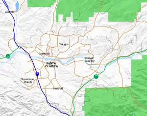 Canyon Country Position in Santa Clarita.  Canyon Country Canyon Country (the Los Angeles metropolitan area)  Canyon Country Canyon Country (California) | |
| Coordinates: 34.42°N 118.47°W | |
| Country | |
| State | |
| County | Los Angeles |
| City | Santa Clarita |
| Elevation | 1,529 ft (466 m) |
| Population (2010) | |
| • Total | 59,530 |
| Time zone | UTC-8 (Pacific (PST)) |
| • Summer (DST) | UTC-7 (PDT) |
| ZIP Code | 91351, 91387, 91390 |
| Area code(s) | 661 |
| GNIS feature ID | 2583151 |
| Website | http://www.santa-clarita.com/ |
| U.S. Geological Survey Geographic Names Information System: Canyon Country, Santa Clarita, California | |
History
The area was the ancestral homeland of the Tataviam people for over five hundred years, and other tribes before then, such as the Tongva, Kitanemuk, and Serrano people. After Spanish settlement, the valley became grazing lands of the Mission San Fernando Rey de España around 1790. In 1834, after Mexican Independence, it became part of the Rancho San Francisco land grant centered on the confluence of the Santa Clara River and Castaic Creek.[2]
In the 1880s, the rancho become the Newhall Ranch empire of Henry Newhall, now the present day Newhall Land and Farming Company. In 1928, the St. Francis Dam collapsed, suddenly flooding and washing away settlements and people along the Santa Clara River section of present-day Santa Clarita not including Canyon Country. Canyon Country was originally to be called Solemint. It later absorbed the community to the west called Honby. In the 1960s and 1970s, the Newhall Land company's suburban developments transformed Canyon Country and the surrounding towns into a focused residential and cultural city.[2]
The house of The Crandall family used in the movie Don't Tell Mom the Babysitter's Dead is located in this community.[3] A home here was also featured in the climax of Real Genius, but it no longer exists.[4]
In 1987, Canyon Country was one of four communities, with Valencia, Newhall, and Saugus, that merged to create the city of Santa Clarita, California. The latitude of Canyon Country is 34.42°N and the longitude is 118.47°W. Canyon Country has a population of 59,530 people.
Geography
Canyon Country is located on the east side of Santa Clarita, along the Santa Clara River. The Sierra Pelona Mountains lie north of the community, and the San Gabriel Mountains lie to the south. Because of its location surrounded by forested mountains (Angeles National Forest), Canyon Country is susceptible to wildfires. The Buckweed Fire in October 2007 burned nearly 38,000 acres throughout Canyon Country and Agua Dulce.[5] The Sand Fire took place in Canyon Country and burned nearly 42,000 acres of land.
Education
Canyon Country elementary school students attend schools in Saugus Union School District and Sulphur Springs School District.[6]
Middle and high school students in Canyon Country attend schools in William S. Hart Union High School District, in particular Sierra Vista and La Mesa Junior High Schools, and Canyon and Golden Valley High Schools.[6]
College of the Canyons has a satellite campus in Canyon Country in addition to its main campus in Valencia. Charter College has a campus in Canyon Country, one of three campuses in California (the others are in Lancaster and Oxnard).
Services
Canyon Country is served by the Los Angeles County Sheriff's Department and Los Angeles County Fire Department, in particular Fire Stations 104 (Quint), 123 (Sand Canyon), and 132 (Canyon Country).
Demographics
See also
- Sand Canyon (part of Canyon Country)
- Lang Southern Pacific Station, a California Historic Landmark
References
- U.S. Geological Survey Geographic Names Information System: Canyon Country, Santa Clarita, California
- "History of Canyon Country". Santa Clarita Valley Historical Society. Retrieved 2004-07-04.
- Iamnotastalker.com
- Ryan, Kyle (April 21, 2010). "Random Roles: William Atherton". The Onion A.V. Club. Retrieved April 21, 2010.
- Fm 98.1, +khts; Am 1220 (2008-10-22). "One Year Later, Buckweed Fire Still Haunts Memories". Hometown Station | KHTS FM 98.1 & AM 1220. Retrieved 2018-12-08.
- "Wm. S. Hart Union High SD". SchoolSite Locator. Retrieved 2020-12-25.
External links
| City | |
|---|---|
| Neighborhoods | |
| Schools | |
| Colleges and universities | |
| Points of interest | |
| Services | |
| Media | |
| Transportation | |
| History | |
| Companies | |