Agua Dulce, California
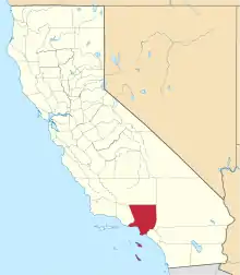
Agua Dulce (Spanish for "sweet water"[3]) is a census-designated place[4] in Los Angeles County, California, United States.[2] It lies at an elevation of 2,526 feet (770 m),[2] northeast of Santa Clarita. The community had a population of 3,342 at the 2010 census[5] and covers a geographic area of about 23 square miles (59 km2). The ZIP code is 91390 (shared with Green Valley and far northern Santa Clarita), and the area code is 661.
Agua Dulce, California | |
|---|---|
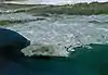
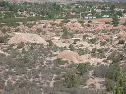 Agua Dulce as seen from Vasquez Rocks | |
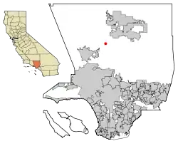 Location within Los Angeles County | |
 Agua Dulce Location in California  Agua Dulce Location in the United States | |
| Coordinates: 34.50°N 118.32°W | |
| Country | |
| State | |
| County | |
| Area | |
| • Total | 22.86 sq mi (59.20 km2) |
| • Land | 22.85 sq mi (59.18 km2) |
| • Water | 0.01 sq mi (0.01 km2) 0.02% |
| Elevation | 2,526 ft (770 m) |
| Population (2010) | |
| • Total | 3,342 |
| • Density | 146.3/sq mi (56.47/km2) |
| Time zone | UTC-8 (Pacific (PST)) |
| • Summer (DST) | UTC-7 (PDT) |
| ZIP codes | 91390 |
| Area code(s) | 661 |
| GNIS feature IDs | 1660235; 2582928 |
| FIPS code | 06-00450 |
| U.S. Geological Survey Geographic Names Information System: Agua Dulce, California; U.S. Geological Survey Geographic Names Information System: Agua Dulce, California | |
Geography
Agua Dulce is located along California State Route 14, halfway between Santa Clarita and Palmdale, and 45 miles (72 km) north of Los Angeles, in the Sierra Pelona Valley region of Southern California. Vasquez Rocks is located at Agua Dulce. The Pacific Crest Trail, which runs from Mexico to Canada, goes through Agua Dulce.
Demographics
At the 2010 census Agua Dulce had a population of 3,342. The population density was 146.3 people per square mile (56.5/km2). The racial makeup of Agua Dulce was 2,854 (85.4%) White (75.5% Non-Hispanic White),[6] 59 (1.8%) Black, 24 (0.7%) Native American, 78 (2.3%) Asian, 3 (0.1%) Pacific Islander, 223 (6.7%) from other races, and 101 (3.0%) from two or more races. Hispanic or Latino of any race were 611 people (18.3%).[7]
The census reported that 3,314 people (99.2% of the population) lived in households, 28 (0.8%) lived in non-institutionalized group quarters, and no one was institutionalized.
There were 1,201 households, 355 (29.6%) had children under the age of 18 living in them, 795 (66.2%) were opposite-sex married couples living together, 72 (6.0%) had a female householder with no husband present, 58 (4.8%) had a male householder with no wife present. There were 64 (5.3%) unmarried opposite-sex partnerships, and 10 (0.8%) same-sex couples or partnerships. 200 households (16.7%) were one person and 73 (6.1%) had someone living alone who was 65 or older. The average household size was 2.76. There were 925 families (77.0% of households); the average family size was 3.06.
The age distribution was 645 people (19.3%) under the age of 18, 310 people (9.3%) aged 18 to 24, 588 people (17.6%) aged 25 to 44, 1,336 people (40.0%) aged 45 to 64, and 463 people (13.9%) who were 65 or older. The median age was 47.3 years. For every 100 females, there were 101.7 males. For every 100 females age 18 and over, there were 102.0 males.
There were 1,277 housing units at an average density of 55.9 per square mile, of the occupied units 1,058 (88.1%) were owner-occupied and 143 (11.9%) were rented. The homeowner vacancy rate was 1.2%; the rental vacancy rate was 3.4%. 2,929 people (87.6% of the population) lived in owner-occupied housing units and 385 people (11.5%) lived in rental housing units.
According to the 2010 United States Census, Agua Dulce had a median household income of $103,333, with 2.5% of the population living below the federal poverty line.[8]
Education
Filming location
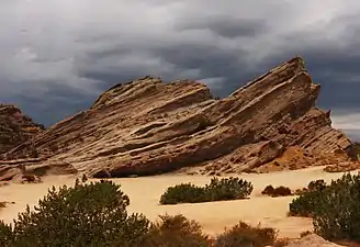
Vasquez Rocks has long been used as a popular filming location by the Hollywood movie industry, most notably The Flintstones movie, Mel Brooks' Blazing Saddles, The Invaders episode "The Saucer", and the Star Trek episode "Arena." The 1971 movie Duel filmed extensively in the area, as was the western film More Dead Than Alive. Other films shot in the area are Rat Race, 127 Hours, Bill & Ted's Bogus Journey and The Immaculate Conception of Little Dizzle. The History channel shoots the popular reality TV show "Top Shot" in the hills and canyons on the north side of the valley. Reno 911 has filmed in locations off of Soledad Canyon Road.
The Agua Dulce area has played host to music video shoots, including those for Tom Petty and the Heartbreakers "You Got Lucky", Bloodhound Gang's "Your Only Friends Are Make-Believe", Weird Al Yankovic's "I Love Rocky Road", and various Nike commercials. L.A. based rockers and "Rat Pack" recording artist "Roxanne" filmed "Super Bad" at the Diamond View Ranch in Agua Dulce.
Vasquez Rocks got its name from the famous bandit Tiburcio Vásquez who used them as a hideout.
Transportation
Agua Dulce has a general aviation airport known as Agua Dulce Airpark. The Airpark and surrounding area was the location for the ABC game show 101 Ways to Leave a Gameshow which premiered on 21 June 2011.
References
- "2016 U.S. Gazetteer Files". United States Census Bureau. Retrieved 19 July 2017.
- U.S. Geological Survey Geographic Names Information System: Agua Dulce, California
- William Bright; Erwin Gustav Gudde (1998). 1500 California Place Names: Their Origin and Meaning. University of California Press. p. 10. ISBN 978-0-520-21271-8.
- U.S. Geological Survey Geographic Names Information System: Agua Dulce, California
- "Geographic Identifiers: 2010 Census Summary File 1 (G001), Agua Dulce CDP, California". American FactFinder. U.S. Census Bureau. Archived from the original on 13 February 2020. Retrieved 4 September 2019.
- "Profile of General Population and Housing Characteristics: 2010 Demographic Profile Data". American FactFinder. United States Census Bureau. Archived from the original on 17 January 2015. Retrieved 12 January 2015.
- "2010 Census Interactive Population Search: CA - Agua Dulce CDP". U.S. Census Bureau. Archived from the original on 23 September 2015. Retrieved 12 July 2014.
- "United States Population: Census 2010 Total Population". United States Census Bureau.
- "Acton-Agua Dulce Unified School District". Aadusd.k12.ca.us. Retrieved 4 October 2010.
- "Vasquez High School". Aadusd.org. Retrieved 16 February 2016.
- "High Desert School". Aadusd.k12.ca.us. Archived from the original on 6 February 2010. Retrieved 4 October 2010.
- "Meadowlark School". Aadusd.org. Retrieved 6 November 2011.
- "Agua Dulce Elementary School". Aadusd.k12.ca.us. Archived from the original on 18 July 2011. Retrieved 4 October 2010.
External links
- Agua Dulce Town Council
- Township of Agua Dulce
- Acton/Agua Dulce News, local newspaper
- "Agua Dulce and Vasquez Rocks History". Santa Clarita Valley Historical Society. Archived from the original on 3 August 2004. Retrieved 4 July 2004. (Photos, text, TV shows)
- Agua Dulce Vineyards
- Vanguard News Agua Dulce and Acton news online
- Weather information for Agua Dulce and Acton
Places adjacent to Agua Dulce, California | |
|---|---|
| City | |
|---|---|
| Neighborhoods | |
| Schools | |
| Colleges and universities | |
| Points of interest | |
| Services | |
| Media | |
| Transportation | |
| History | |
| Companies | |
| Authority control |
|---|